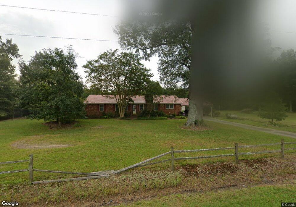
4459 Bear Creek Rd La Grange, NC 28551
Estimated Value: $241,782 - $322,000
2
Beds
2
Baths
1,856
Sq Ft
$151/Sq Ft
Est. Value
About This Home
This home is located at 4459 Bear Creek Rd, La Grange, NC 28551 and is currently estimated at $280,446, approximately $151 per square foot. 4459 Bear Creek Rd is a home located in Lenoir County with nearby schools including La Grange Elementary School, E.B. Frink Middle School, and North Lenoir High School.
Ownership History
Date
Name
Owned For
Owner Type
Purchase Details
Closed on
Nov 19, 2020
Sold by
Jackson Conner
Bought by
Braswell Ivan N and Braswell Penny W
Current Estimated Value
Purchase Details
Closed on
Apr 24, 2019
Sold by
Miles Norman and Miles Margaret
Bought by
Miles Norman and Miles Margaret
Purchase Details
Closed on
Feb 8, 2019
Sold by
Lewis Willaim R
Bought by
Conner Mills Sharon L and Conner Jackson
Create a Home Valuation Report for This Property
The Home Valuation Report is an in-depth analysis detailing your home's value as well as a comparison with similar homes in the area
Home Values in the Area
Average Home Value in this Area
Purchase History
| Date | Buyer | Sale Price | Title Company |
|---|---|---|---|
| Braswell Ivan N | $13,500 | None Available | |
| Miles Norman | $1,500 | -- | |
| Lewis William R | $3,500 | -- | |
| Conner Mills Sharon L | $10,000 | -- |
Source: Public Records
Tax History Compared to Growth
Tax History
| Year | Tax Paid | Tax Assessment Tax Assessment Total Assessment is a certain percentage of the fair market value that is determined by local assessors to be the total taxable value of land and additions on the property. | Land | Improvement |
|---|---|---|---|---|
| 2025 | $1,463 | $186,848 | $19,554 | $167,294 |
| 2024 | $1,225 | $122,248 | $14,628 | $107,620 |
| 2023 | $1,172 | $122,248 | $14,628 | $107,620 |
| 2022 | $1,172 | $122,248 | $14,628 | $107,620 |
| 2021 | $1,172 | $122,248 | $14,628 | $107,620 |
| 2020 | $1,172 | $122,248 | $14,628 | $107,620 |
| 2019 | $1,172 | $122,248 | $14,628 | $107,620 |
| 2018 | $1,156 | $122,248 | $14,628 | $107,620 |
| 2017 | $1,154 | $122,248 | $14,628 | $107,620 |
| 2014 | $1,148 | $121,424 | $14,628 | $106,796 |
| 2013 | -- | $121,424 | $14,628 | $106,796 |
| 2011 | -- | $121,424 | $14,628 | $106,796 |
Source: Public Records
Map
Nearby Homes
- 5517 Bulltown Rd
- 6272 Highway 70 E
- 4725 Packhouse Rd
- 3619 S Caswell St
- 805 Madison Ann Dr
- 5301 Barber Rd
- 614 S Caswell St
- 210 Wood St
- 201 Wood St
- 202 Wood St
- 208 Wood St
- 217 Wood St
- 204 Wood St
- 205 Wood St
- 206 Wood St
- Hayden Plan at Blair Ridge
- Freeport Plan at Blair Ridge
- Cali Plan at Blair Ridge
- Belhaven Plan at Blair Ridge
- 219 Wood St
- 4431 Bear Creek Rd
- 4497 Bear Creek Rd
- 4517 Bear Creek Rd
- 1961 Jenny Lind Rd
- 1933 Jenny Lind Rd
- 2062 Jenny Lind Rd
- 2110 Jenny Lind Rd
- 1861 Jenny Lind Rd
- 1862 Jenny Lind Rd
- 4682 Bulltown Rd
- 2138 Hardy Bridge Rd
- 2172 Hardy Bridge Rd
- 5907 Kennedy Home Rd
- 4720 Bulltown Rd
- 1743 Jenny Lind Rd
- 4516 Cox Farms Rd
- 2200 Hardy Bridge Rd
- 4677 Bear Creek Rd
- 2100 Hardy Bridge Rd
- 1759 Jenny Lind Rd