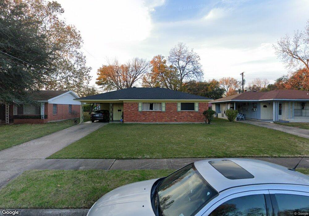
446 Apache Trail Shreveport, LA 71107
Freestate-North Highlands NeighborhoodEstimated Value: $64,043 - $80,000
3
Beds
1
Bath
1,175
Sq Ft
$61/Sq Ft
Est. Value
About This Home
This home is located at 446 Apache Trail, Shreveport, LA 71107 and is currently estimated at $72,011, approximately $61 per square foot. 446 Apache Trail is a home located in Caddo Parish with nearby schools including Cherokee Park Elementary School, Fairfield Magnet School, and Claiborne Fundamental Elementary School.
Ownership History
Date
Name
Owned For
Owner Type
Purchase Details
Closed on
Apr 5, 2007
Sold by
Cowthorn Rickey Ray and Edwards Cowthorn Erma Lynell
Bought by
Tillman Judy Lynn
Current Estimated Value
Home Financials for this Owner
Home Financials are based on the most recent Mortgage that was taken out on this home.
Original Mortgage
$70,000
Outstanding Balance
$41,475
Interest Rate
6.24%
Mortgage Type
Purchase Money Mortgage
Estimated Equity
$30,536
Create a Home Valuation Report for This Property
The Home Valuation Report is an in-depth analysis detailing your home's value as well as a comparison with similar homes in the area
Home Values in the Area
Average Home Value in this Area
Purchase History
| Date | Buyer | Sale Price | Title Company |
|---|---|---|---|
| Tillman Judy Lynn | $70,000 | None Available |
Source: Public Records
Mortgage History
| Date | Status | Borrower | Loan Amount |
|---|---|---|---|
| Open | Tillman Judy Lynn | $70,000 |
Source: Public Records
Tax History
| Year | Tax Paid | Tax Assessment Tax Assessment Total Assessment is a certain percentage of the fair market value that is determined by local assessors to be the total taxable value of land and additions on the property. | Land | Improvement |
|---|---|---|---|---|
| 2025 | $759 | $4,852 | $750 | $4,102 |
| 2024 | $756 | $4,852 | $750 | $4,102 |
| 2023 | $768 | $4,816 | $714 | $4,102 |
| 2022 | $768 | $4,816 | $714 | $4,102 |
| 2021 | $756 | $4,816 | $714 | $4,102 |
| 2020 | $756 | $4,816 | $714 | $4,102 |
| 2019 | $772 | $4,771 | $714 | $4,057 |
| 2018 | $0 | $4,771 | $714 | $4,057 |
| 2017 | $784 | $4,771 | $714 | $4,057 |
| 2015 | -- | $4,900 | $710 | $4,190 |
| 2014 | -- | $4,900 | $710 | $4,190 |
| 2013 | -- | $4,900 | $710 | $4,190 |
Source: Public Records
Map
Nearby Homes
- 0 Bird Island None Unit 2541395
- 1209 Crestmoor Dr
- 130 Mayfair Dr
- 1113 Fenwick Dr
- 0 N Hearne Ave
- 4925 N Market St
- 0000 N Market St
- 0 Silver Point Dr Unit 11 20803059
- 0 Silver Point Dr Unit 5A 20802976
- 0 Silver Point Dr Unit 7 20803008
- 0 Silver Point Dr Unit 4 20796401
- 0 Silver Point Dr Unit 3 20803133
- 3145 Old Mooringsport Rd
- 0 Timberlane Dr
- 0 Hwy 1 Unit 20326562
- 1805 Traffic St
- 202 Kelly St
- 401 Berry St
- 223 Edwards St
- 1551 Clay St
- 442 Apache Trail
- 450 Apache Trail
- 438 Apache Trail
- 454 Apache Trail
- 445 Choctaw Trail
- 437 Choctaw Trail
- 449 Choctaw Trail
- 433 Choctaw Trail
- 449 Apache Trail
- 453 Apache Trail
- 458 Apache Trail
- 445 Apache Trail
- 441 Apache Trail
- 457 Apache Trail
- 453 Choctaw Trail
- 429 Choctaw Trail
- 430 Apache Trail
- 462 Apache Trail
- 437 Apache Trail
- 425 Choctaw Trail
Your Personal Tour Guide
Ask me questions while you tour the home.