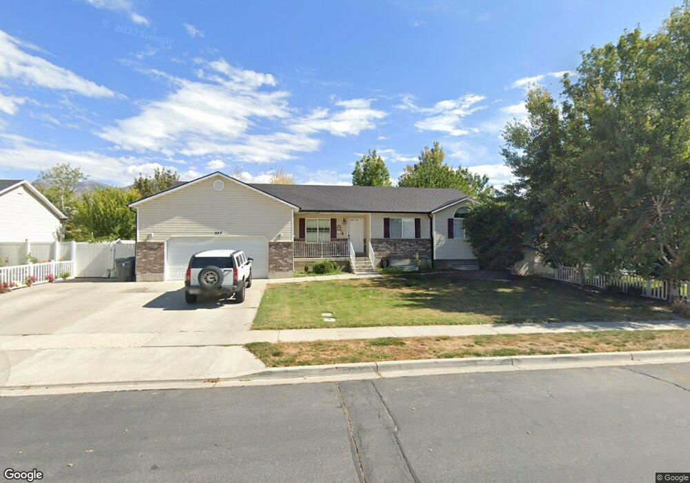
446 N 700 W Unit Lot 23 American Fork, UT 84003
Estimated Value: $598,000 - $667,000
3
Beds
2
Baths
3,520
Sq Ft
$182/Sq Ft
Est. Value
About This Home
This home is located at 446 N 700 W Unit Lot 23, American Fork, UT 84003 and is currently estimated at $639,101, approximately $181 per square foot. 446 N 700 W Unit Lot 23 is a home located in Utah County with nearby schools including Shelley Elementary School, American Fork Junior High School, and American Fork High School.
Ownership History
Date
Name
Owned For
Owner Type
Purchase Details
Closed on
Apr 26, 2021
Sold by
Sotto Heather
Bought by
Sotto Heather and Sotto Michael
Current Estimated Value
Home Financials for this Owner
Home Financials are based on the most recent Mortgage that was taken out on this home.
Original Mortgage
$368,300
Outstanding Balance
$271,354
Interest Rate
2.4%
Mortgage Type
New Conventional
Estimated Equity
$367,747
Purchase Details
Closed on
Apr 20, 2021
Sold by
Sotto Heather
Bought by
Sotto Heather and Sotto Michael
Home Financials for this Owner
Home Financials are based on the most recent Mortgage that was taken out on this home.
Original Mortgage
$368,300
Outstanding Balance
$271,354
Interest Rate
2.4%
Mortgage Type
New Conventional
Estimated Equity
$367,747
Purchase Details
Closed on
Aug 12, 2016
Sold by
Matishen Andrew
Bought by
Scotto Heather
Home Financials for this Owner
Home Financials are based on the most recent Mortgage that was taken out on this home.
Original Mortgage
$292,500
Interest Rate
3.42%
Mortgage Type
New Conventional
Purchase Details
Closed on
Aug 20, 2015
Sold by
Matishen Andrew and Matishen Vera
Bought by
Matishen Andrew
Home Financials for this Owner
Home Financials are based on the most recent Mortgage that was taken out on this home.
Original Mortgage
$240,000
Interest Rate
3.97%
Mortgage Type
New Conventional
Purchase Details
Closed on
Jul 30, 2008
Sold by
Matishen Andrew
Bought by
Matishen Andrew and Matishen Vera
Home Financials for this Owner
Home Financials are based on the most recent Mortgage that was taken out on this home.
Original Mortgage
$197,000
Interest Rate
6.41%
Mortgage Type
New Conventional
Purchase Details
Closed on
May 26, 2006
Sold by
Mcmullin Matthew R and Mcmullin Candi
Bought by
Matishen Andrew and Matishen Vera
Home Financials for this Owner
Home Financials are based on the most recent Mortgage that was taken out on this home.
Original Mortgage
$100,000
Interest Rate
6.46%
Mortgage Type
Purchase Money Mortgage
Purchase Details
Closed on
Apr 26, 1999
Sold by
D R Horton Inc
Bought by
Mcmullin Matthew R and Mcmullin Candi
Home Financials for this Owner
Home Financials are based on the most recent Mortgage that was taken out on this home.
Original Mortgage
$157,000
Interest Rate
6.98%
Create a Home Valuation Report for This Property
The Home Valuation Report is an in-depth analysis detailing your home's value as well as a comparison with similar homes in the area
Home Values in the Area
Average Home Value in this Area
Purchase History
| Date | Buyer | Sale Price | Title Company |
|---|---|---|---|
| Sotto Heather | -- | First American Title Insurance | |
| Sotto Heather | -- | First American | |
| Scotto Heather | -- | First American Title Ins Co | |
| Matishen Andrew | -- | Liberty Title & Escrow Co | |
| Matishen Andrew | -- | Greenbrier Title Insurance | |
| Matishen Andrew | -- | Greenbrier Title Insurance | |
| Matishen Andrew | -- | Backman Orem | |
| Mcmullin Matthew R | -- | First American Title Co |
Source: Public Records
Mortgage History
| Date | Status | Borrower | Loan Amount |
|---|---|---|---|
| Open | Sotto Heather | $368,300 | |
| Closed | Sotto Heather | $368,300 | |
| Previous Owner | Scotto Heather | $292,500 | |
| Previous Owner | Matishen Andrew | $240,000 | |
| Previous Owner | Matishen Andrew | $197,000 | |
| Previous Owner | Matishen Andrew | $100,000 | |
| Previous Owner | Mcmullin Matthew R | $157,000 |
Source: Public Records
Tax History Compared to Growth
Tax History
| Year | Tax Paid | Tax Assessment Tax Assessment Total Assessment is a certain percentage of the fair market value that is determined by local assessors to be the total taxable value of land and additions on the property. | Land | Improvement |
|---|---|---|---|---|
| 2025 | $2,727 | $326,480 | $220,700 | $372,900 |
| 2024 | $2,727 | $303,050 | $0 | $0 |
| 2023 | $2,577 | $303,600 | $0 | $0 |
| 2022 | $2,754 | $320,210 | $0 | $0 |
| 2021 | $2,365 | $429,400 | $158,400 | $271,000 |
| 2020 | $2,215 | $390,000 | $141,400 | $248,600 |
| 2019 | $2,083 | $379,400 | $130,800 | $248,600 |
| 2018 | $1,952 | $340,000 | $123,800 | $216,200 |
| 2017 | $1,886 | $177,265 | $0 | $0 |
| 2016 | $1,789 | $156,255 | $0 | $0 |
| 2015 | $1,837 | $152,240 | $0 | $0 |
| 2014 | $1,659 | $135,630 | $0 | $0 |
Source: Public Records
Map
Nearby Homes
- 777 W State Rd
- 962 N 780 St W Unit 508
- 974 N 780 St W Unit 509
- 916 N 780 St W Unit 501
- 356 N 480 W
- 641 N 420 W
- 822 W 800 St N Unit LOT319
- 822 N 860 W Unit 317
- 602 W 860 N
- 399 W Pacific Dr
- 540 N 300 W
- 370 W Pacific Dr Unit 1
- 901 N Lakota Rd
- 120 N 350 W Unit 127
- 120 N 350 W Unit 133
- 120 N 350 W Unit 130
- 328 N 1270 E
- 914 N 400 W Unit A
- 3935 W 1000 N Unit 438
- 3983 W 1000 N Unit 442