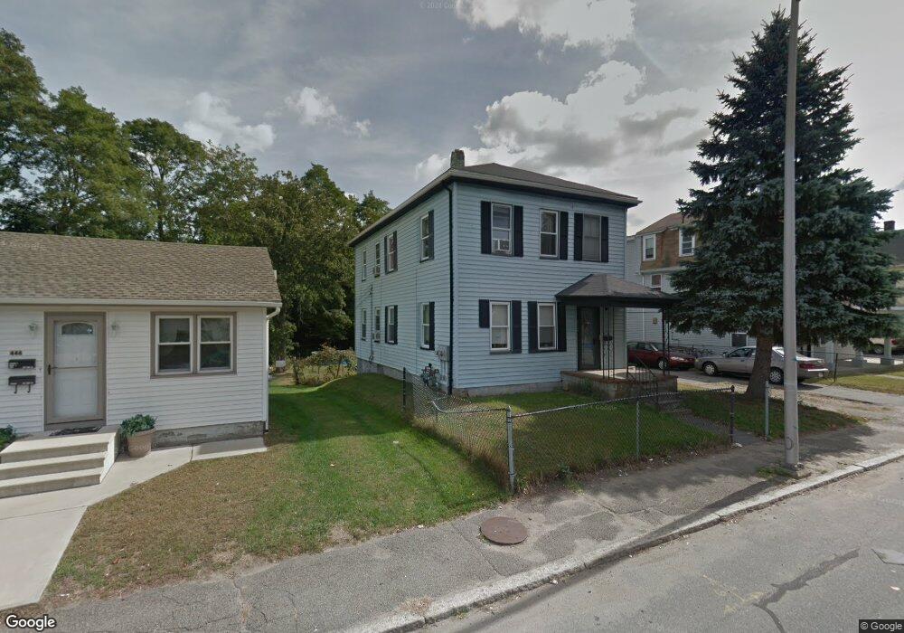
446 Weir St Taunton, MA 02780
Estimated Value: $172,000 - $455,000
1
Bed
1
Bath
600
Sq Ft
$554/Sq Ft
Est. Value
About This Home
This home is located at 446 Weir St, Taunton, MA 02780 and is currently estimated at $332,618, approximately $554 per square foot. 446 Weir St is a home located in Bristol County with nearby schools including Mulcahey Elementary School, Taunton High School, and Our Lady of Lourdes School.
Ownership History
Date
Name
Owned For
Owner Type
Purchase Details
Closed on
Jul 27, 2022
Sold by
Jose C Resendes T
Bought by
Ludy C Resends Family Irt
Current Estimated Value
Purchase Details
Closed on
Aug 25, 1998
Sold by
Bankboston Na
Bought by
Resendes Jose C
Home Financials for this Owner
Home Financials are based on the most recent Mortgage that was taken out on this home.
Original Mortgage
$28,900
Interest Rate
6.86%
Mortgage Type
Purchase Money Mortgage
Purchase Details
Closed on
May 19, 1998
Sold by
Ratcliffe Paul W
Bought by
Bankboston Na
Purchase Details
Closed on
Sep 30, 1994
Sold by
Darrow Ernest E
Bought by
Ratcliffe Paul W
Home Financials for this Owner
Home Financials are based on the most recent Mortgage that was taken out on this home.
Original Mortgage
$61,750
Interest Rate
8.5%
Mortgage Type
Purchase Money Mortgage
Purchase Details
Closed on
Feb 12, 1993
Sold by
Nichols Ft and Murphy Bernard J
Bought by
Darrow Ernest E
Home Financials for this Owner
Home Financials are based on the most recent Mortgage that was taken out on this home.
Original Mortgage
$43,200
Interest Rate
8.13%
Mortgage Type
Purchase Money Mortgage
Create a Home Valuation Report for This Property
The Home Valuation Report is an in-depth analysis detailing your home's value as well as a comparison with similar homes in the area
Home Values in the Area
Average Home Value in this Area
Purchase History
| Date | Buyer | Sale Price | Title Company |
|---|---|---|---|
| Ludy C Resends Family Irt | -- | None Available | |
| Resendes Jose C | $34,000 | -- | |
| Bankboston Na | $68,025 | -- | |
| Ratcliffe Paul W | $65,000 | -- | |
| Darrow Ernest E | $54,000 | -- |
Source: Public Records
Mortgage History
| Date | Status | Borrower | Loan Amount |
|---|---|---|---|
| Previous Owner | Darrow Ernest E | $36,500 | |
| Previous Owner | Darrow Ernest E | $28,900 | |
| Previous Owner | Darrow Ernest E | $61,750 | |
| Previous Owner | Darrow Ernest E | $43,200 |
Source: Public Records
Tax History Compared to Growth
Tax History
| Year | Tax Paid | Tax Assessment Tax Assessment Total Assessment is a certain percentage of the fair market value that is determined by local assessors to be the total taxable value of land and additions on the property. | Land | Improvement |
|---|---|---|---|---|
| 2025 | $3,179 | $290,600 | $97,200 | $193,400 |
| 2024 | $2,979 | $266,200 | $97,200 | $169,000 |
| 2023 | $2,929 | $243,100 | $97,200 | $145,900 |
| 2022 | $2,786 | $211,400 | $81,000 | $130,400 |
| 2021 | $2,648 | $186,500 | $73,700 | $112,800 |
| 2020 | $2,639 | $177,600 | $73,700 | $103,900 |
| 2019 | $2,758 | $175,000 | $73,700 | $101,300 |
| 2018 | $2,520 | $160,300 | $73,600 | $86,700 |
| 2017 | $2,422 | $154,200 | $69,800 | $84,400 |
| 2016 | $2,336 | $149,000 | $67,800 | $81,200 |
| 2015 | $2,285 | $152,200 | $68,200 | $84,000 |
| 2014 | $2,130 | $145,800 | $65,800 | $80,000 |
Source: Public Records
Map
Nearby Homes
- 4 Parkin Ct
- 252 Somerset Ave
- 24 1st St
- 6 Southeast St
- 450 Somerset Ave Unit 2-7
- 450 Somerset Ave Unit 6-6
- 215 High St Unit 21
- 215 High St Unit 20
- 16 Clinton St
- 1301 Carriage Ln Unit 1301
- 6 W Summer St
- 41 Hart Ave
- 22 Everett St
- 90 E Water St
- 72 Barnum St
- 46 Harrison St Unit 4
- 71 Linden St
- 278 Cohannet St
- 98 Winthrop St
- 8 Herbert St