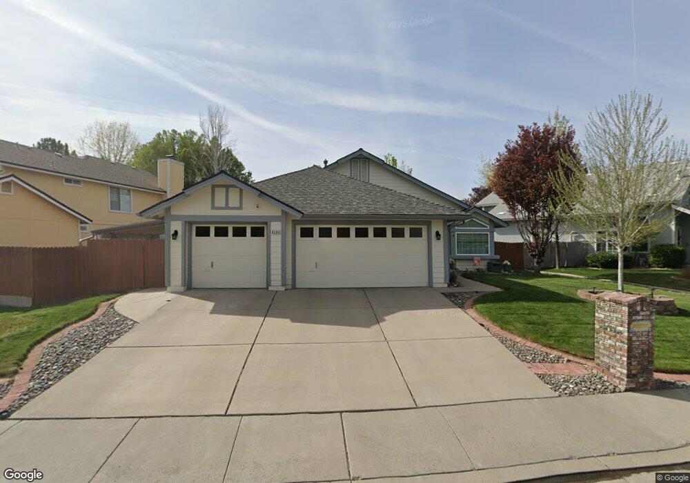
4464 Whitney Cir Sparks, NV 89436
Los Altos Parkway NeighborhoodEstimated Value: $522,000 - $579,000
3
Beds
2
Baths
1,692
Sq Ft
$321/Sq Ft
Est. Value
About This Home
This home is located at 4464 Whitney Cir, Sparks, NV 89436 and is currently estimated at $543,245, approximately $321 per square foot. 4464 Whitney Cir is a home located in Washoe County with nearby schools including Bud Beasley Elementary School, Lou Mendive Middle School, and Edward C Reed High School.
Ownership History
Date
Name
Owned For
Owner Type
Purchase Details
Closed on
Jul 7, 1995
Sold by
Smith Robert J and Smith Delores J
Bought by
Browning Kevin R and Browning Susan K
Current Estimated Value
Home Financials for this Owner
Home Financials are based on the most recent Mortgage that was taken out on this home.
Original Mortgage
$139,250
Interest Rate
7.62%
Create a Home Valuation Report for This Property
The Home Valuation Report is an in-depth analysis detailing your home's value as well as a comparison with similar homes in the area
Home Values in the Area
Average Home Value in this Area
Purchase History
| Date | Buyer | Sale Price | Title Company |
|---|---|---|---|
| Browning Kevin R | $155,000 | First Centennial Title Co |
Source: Public Records
Mortgage History
| Date | Status | Borrower | Loan Amount |
|---|---|---|---|
| Closed | Browning Kevin R | $139,250 |
Source: Public Records
Tax History Compared to Growth
Tax History
| Year | Tax Paid | Tax Assessment Tax Assessment Total Assessment is a certain percentage of the fair market value that is determined by local assessors to be the total taxable value of land and additions on the property. | Land | Improvement |
|---|---|---|---|---|
| 2025 | $2,369 | $95,719 | $42,560 | $53,159 |
| 2024 | $2,369 | $94,075 | $40,075 | $54,000 |
| 2023 | $2,300 | $90,173 | $38,710 | $51,463 |
| 2022 | $2,234 | $76,032 | $32,830 | $43,202 |
| 2021 | $2,170 | $67,152 | $23,835 | $43,317 |
| 2020 | $2,105 | $67,507 | $23,800 | $43,707 |
| 2019 | $2,044 | $66,866 | $24,360 | $42,506 |
| 2018 | $1,985 | $59,638 | $17,780 | $41,858 |
| 2017 | $1,928 | $58,614 | $16,450 | $42,164 |
| 2016 | $1,878 | $57,799 | $14,525 | $43,274 |
| 2015 | $940 | $56,422 | $12,880 | $43,542 |
| 2014 | $1,820 | $53,152 | $10,885 | $42,267 |
| 2013 | -- | $47,026 | $8,925 | $38,101 |
Source: Public Records
Map
Nearby Homes
- 4515 Whitney Cir
- 1357 Silver View Cir
- 4788 Ravello Dr
- 4748 Pradera St
- 3988 Ella Jayne Ct Unit Lot 6
- 1484 Serendipity Ct
- 1215 Ebling Dr
- 4950 San Diego Ct
- 1557 Satellite Dr
- 4750 Desert Song Ct
- 1475 Golddust Dr
- 1550 Istrice Rd
- 4675 Firtree Ln
- 4393 Acobat Ct
- 1560 Freeman Way
- 519 N Sand Crane Cir
- 4794 Sage Thrasher Way
- 5049 Keams Ct
- 510 S Sand Crane Cir
- 1304 Lambrusca Dr
- 4468 Whitney Cir
- 4454 Whitney Cir
- 4496 Trenton Ct
- 4488 Whitney Cir
- 4465 Steeple Ct
- 4434 Whitney Cir
- 4455 Imperial Ct
- 4502 Trenton Ct Unit 1
- 4424 Whitney Cir
- 4467 Steeple Ct
- 4485 Whitney Cir
- 4451 Imperial Ct
- 4524 Trenton Ct
- 4408 Whitney Cir
- 4435 Imperial Ct
- 4495 Whitney Cir
- 4528 Whitney Cir
- 4481 Steeple Ct Unit 1
- 4471 Steeple Ct
- 4505 Whitney Cir