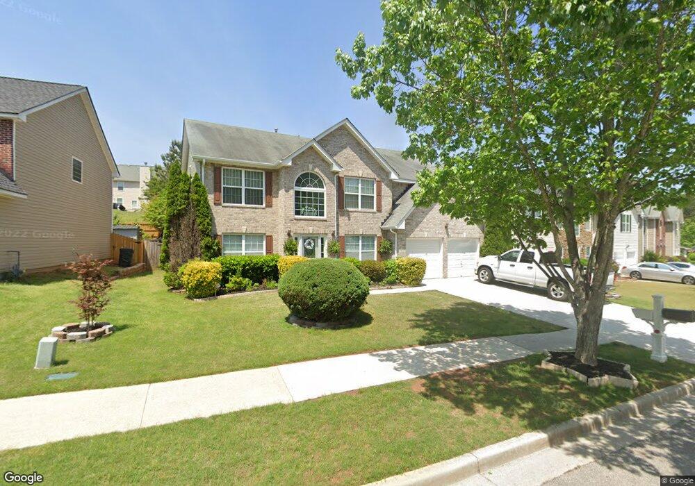
4465 Michael Jay St Snellville, GA 30039
Estimated Value: $400,115 - $435,000
5
Beds
3
Baths
3,094
Sq Ft
$136/Sq Ft
Est. Value
About This Home
This home is located at 4465 Michael Jay St, Snellville, GA 30039 and is currently estimated at $419,779, approximately $135 per square foot. 4465 Michael Jay St is a home located in Gwinnett County with nearby schools including Rosebud Elementary School, Grace Snell Middle School, and South Gwinnett High School.
Ownership History
Date
Name
Owned For
Owner Type
Purchase Details
Closed on
May 18, 2022
Sold by
Giles Owen
Bought by
Bay Street Homes Llc
Current Estimated Value
Purchase Details
Closed on
Dec 29, 2006
Sold by
Giles Owen
Bought by
Giles Owen and Giles Karen A
Home Financials for this Owner
Home Financials are based on the most recent Mortgage that was taken out on this home.
Original Mortgage
$178,450
Interest Rate
8.25%
Mortgage Type
New Conventional
Create a Home Valuation Report for This Property
The Home Valuation Report is an in-depth analysis detailing your home's value as well as a comparison with similar homes in the area
Home Values in the Area
Average Home Value in this Area
Purchase History
| Date | Buyer | Sale Price | Title Company |
|---|---|---|---|
| Bay Street Homes Llc | $420,000 | -- | |
| Giles Owen | $223,100 | -- | |
| Giles Owen | $223,100 | -- |
Source: Public Records
Mortgage History
| Date | Status | Borrower | Loan Amount |
|---|---|---|---|
| Previous Owner | Giles Owen | $178,450 | |
| Previous Owner | Giles Owen | $33,450 |
Source: Public Records
Tax History Compared to Growth
Tax History
| Year | Tax Paid | Tax Assessment Tax Assessment Total Assessment is a certain percentage of the fair market value that is determined by local assessors to be the total taxable value of land and additions on the property. | Land | Improvement |
|---|---|---|---|---|
| 2025 | $5,786 | $154,200 | $30,000 | $124,200 |
| 2024 | $5,850 | $154,200 | $30,000 | $124,200 |
| 2023 | $5,850 | $154,880 | $29,680 | $125,200 |
| 2022 | $4,128 | $130,000 | $22,000 | $108,000 |
| 2021 | $3,616 | $102,880 | $14,000 | $88,880 |
| 2020 | $3,406 | $92,120 | $14,000 | $78,120 |
| 2019 | $3,290 | $92,120 | $14,000 | $78,120 |
| 2018 | $3,080 | $84,720 | $12,000 | $72,720 |
| 2016 | $2,448 | $66,080 | $10,000 | $56,080 |
| 2015 | $2,241 | $59,600 | $8,800 | $50,800 |
| 2014 | $2,252 | $59,600 | $8,800 | $50,800 |
Source: Public Records
Map
Nearby Homes
- 4041 Ash Tree St
- 4381 Ash Tree St
- 4850 Wynship Ln
- 3770 Belle Glade Trail
- 4348 Bradley Dr
- 4366 Bradley Dr SW
- 4244 Bradley Dr SW
- 0 Bradley Dr SW
- 0 Bryant Rd Unit 7646847
- 4738 Chafin Point Ct
- 4840 Heather Mill Trace
- 4380 Cary Dr
- 4469 Persian Ct
- 4656 Bryant Rd
- 3630 Gin Way Unit 1
- 4440 Cary Dr
- 4232 Marjorie Rd
- 4440 Cary Dr SW
- 3892 Rosebud Park Dr
- 4300 Burdett Place
- 4465 Michael Jay St
- 4465 Michael Jay St Unit PH 4
- 4455 Michael Jay St
- 4475 Michael Jay St
- 0 Michael Jay St
- 4485 Michael Jay St
- 4445 Michael Jay St
- 4947 Bottle Brush Ct
- 4464 Michael Jay St
- 4937 Bottle Brush Ct
- 4454 Michael Jay St
- 4957 Bottle Brush Ct
- 4505 Michael Jay St
- 4435 Michael Jay St
- 4484 Michael Jay St
- 4444 Michael Jay St
- 4927 Bottle Brush Ct
- 4494 Michael Jay St
- 4967 Bottle Brush Ct
- 4434 Michael Jay St