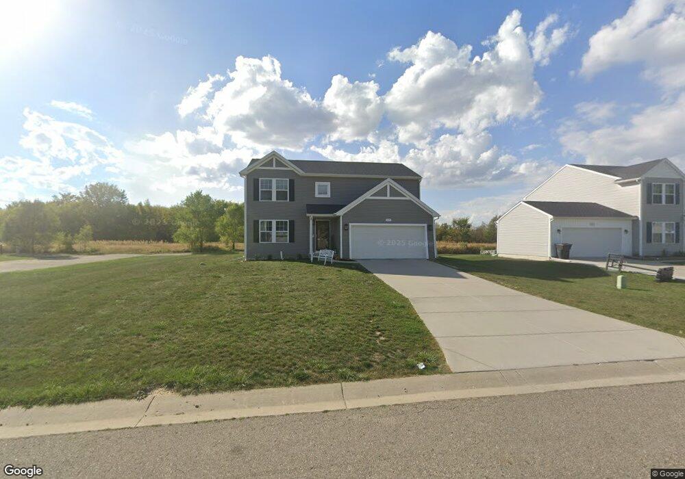
4476 Soya Ave Swartz Creek, MI 48473
Estimated Value: $311,000 - $378,460
--
Bed
1
Bath
2,000
Sq Ft
$170/Sq Ft
Est. Value
About This Home
This home is located at 4476 Soya Ave, Swartz Creek, MI 48473 and is currently estimated at $340,365, approximately $170 per square foot. 4476 Soya Ave is a home located in Genesee County with nearby schools including Elms Road Elementary School, Syring Elementary School, and Morrish Elementary School.
Ownership History
Date
Name
Owned For
Owner Type
Purchase Details
Closed on
Oct 7, 2020
Sold by
Westview Capital Llc
Bought by
Woods James Anthony and Woods Alicia
Current Estimated Value
Home Financials for this Owner
Home Financials are based on the most recent Mortgage that was taken out on this home.
Original Mortgage
$228,890
Interest Rate
2.65%
Mortgage Type
New Conventional
Purchase Details
Closed on
Jul 2, 2020
Sold by
Amber Land Development Llc
Bought by
Westview Capital Llc
Purchase Details
Closed on
Sep 19, 2007
Sold by
Peck Ted and Peck Connie J
Bought by
Amber Land Development Llc
Create a Home Valuation Report for This Property
The Home Valuation Report is an in-depth analysis detailing your home's value as well as a comparison with similar homes in the area
Home Values in the Area
Average Home Value in this Area
Purchase History
| Date | Buyer | Sale Price | Title Company |
|---|---|---|---|
| Woods James Anthony | $27,500 | Devon Title | |
| Westview Capital Llc | -- | Amrock Inc | |
| Amber Land Development Llc | -- | Chicago Title Insurance Co |
Source: Public Records
Mortgage History
| Date | Status | Borrower | Loan Amount |
|---|---|---|---|
| Previous Owner | Woods James Anthony | $228,890 |
Source: Public Records
Tax History Compared to Growth
Tax History
| Year | Tax Paid | Tax Assessment Tax Assessment Total Assessment is a certain percentage of the fair market value that is determined by local assessors to be the total taxable value of land and additions on the property. | Land | Improvement |
|---|---|---|---|---|
| 2025 | $5,920 | $177,000 | $0 | $0 |
| 2024 | $3,309 | $163,100 | $0 | $0 |
| 2023 | $3,157 | $147,000 | $0 | $0 |
| 2022 | $2,378 | $127,600 | $0 | $0 |
| 2021 | $352 | $3,100 | $0 | $0 |
| 2020 | $130 | $3,100 | $0 | $0 |
| 2019 | $131 | $3,100 | $0 | $0 |
| 2018 | $205 | $3,100 | $0 | $0 |
| 2017 | $222 | $3,100 | $0 | $0 |
| 2016 | $207 | $3,100 | $0 | $0 |
| 2015 | $166 | $3,100 | $0 | $0 |
| 2014 | $117 | $3,100 | $0 | $0 |
| 2012 | -- | $4,100 | $4,100 | $0 |
Source: Public Records
Map
Nearby Homes
- 5252 Maple Ave
- 4445 Dixon Dr
- 5201 Tokay Dr Unit 95
- 4378 Staunton Dr
- 5196 Tokay Dr Unit 92
- 4341 Staunton Dr
- 5201 Chantelle Dr Unit 134
- 6131 Fountain View Dr Unit 49
- 5454 Miller Rd
- 9403 W Bristol Rd
- 5446 Miller Rd
- 6216 Clubhouse Way
- 46 Bellwood Dr
- 12415 Old Miller Rd
- 0 Miller Rd Unit 31394672
- 6319 Bristol Rd
- 5162 Miller Rd
- 5379 Linden Rd
- 6285 Arlington Dr
- 6011 Oak Creek Dr