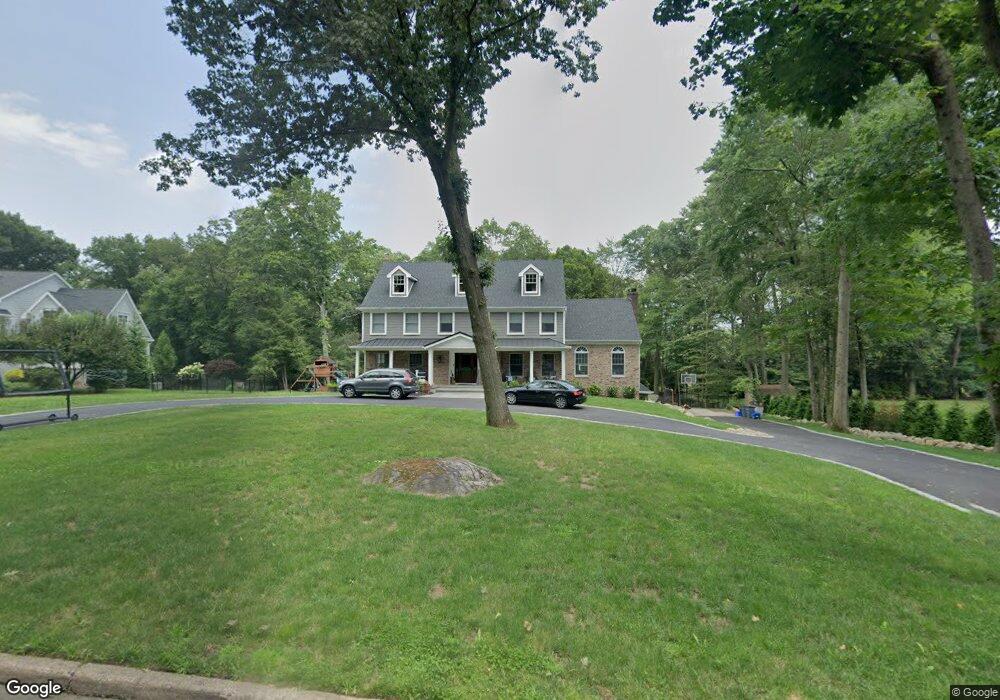
448 Mark Rd Allendale, NJ 07401
Estimated Value: $1,365,000 - $1,781,000
5
Beds
4
Baths
3,583
Sq Ft
$445/Sq Ft
Est. Value
About This Home
This home is located at 448 Mark Rd, Allendale, NJ 07401 and is currently estimated at $1,593,628, approximately $444 per square foot. 448 Mark Rd is a home located in Bergen County with nearby schools including Hillside Elementary School, Brookside Elementary School, and Northern Highlands Reg High School.
Ownership History
Date
Name
Owned For
Owner Type
Purchase Details
Closed on
Nov 8, 2019
Sold by
U S Bank National Association
Bought by
Azmi Ghadimi Hirbod and Smith Stacey
Current Estimated Value
Home Financials for this Owner
Home Financials are based on the most recent Mortgage that was taken out on this home.
Original Mortgage
$761,600
Interest Rate
3.72%
Mortgage Type
New Conventional
Purchase Details
Closed on
Nov 30, 2018
Sold by
Cureton Anthony
Bought by
Us Bank Na
Purchase Details
Closed on
Sep 3, 2003
Create a Home Valuation Report for This Property
The Home Valuation Report is an in-depth analysis detailing your home's value as well as a comparison with similar homes in the area
Home Values in the Area
Average Home Value in this Area
Purchase History
| Date | Buyer | Sale Price | Title Company |
|---|---|---|---|
| Azmi Ghadimi Hirbod | $952,000 | Sunnyside Title Agency Llc | |
| Us Bank Na | -- | -- | |
| -- | -- | -- |
Source: Public Records
Mortgage History
| Date | Status | Borrower | Loan Amount |
|---|---|---|---|
| Previous Owner | Azmi Ghadimi Hirbod | $761,600 |
Source: Public Records
Tax History
| Year | Tax Paid | Tax Assessment Tax Assessment Total Assessment is a certain percentage of the fair market value that is determined by local assessors to be the total taxable value of land and additions on the property. | Land | Improvement |
|---|---|---|---|---|
| 2025 | $32,230 | $1,608,900 | $660,800 | $948,100 |
| 2024 | $30,669 | $1,528,200 | $628,300 | $899,900 |
| 2023 | $30,318 | $1,394,700 | $515,900 | $878,800 |
| 2022 | $30,318 | $1,331,500 | $490,900 | $840,600 |
| 2021 | $29,868 | $1,271,500 | $452,200 | $819,300 |
| 2020 | $24,408 | $1,011,500 | $442,200 | $569,300 |
| 2019 | $23,760 | $1,011,500 | $442,200 | $569,300 |
| 2018 | $23,234 | $1,011,500 | $442,200 | $569,300 |
| 2017 | $23,143 | $1,011,500 | $442,200 | $569,300 |
| 2016 | $23,173 | $1,011,500 | $442,200 | $569,300 |
| 2015 | $22,708 | $1,011,500 | $442,200 | $569,300 |
| 2014 | $23,251 | $975,700 | $442,200 | $533,500 |
Source: Public Records
Map
Nearby Homes
- 314 Meadowbrook Rd
- 89 Barrett Ln
- 37-1 Tamaron Dr
- 53 Lockwood Dr
- 12 Sandburg Ct
- 16 Sandburg Ct Unit 16
- 8 Masterson Ct
- 8 Edgewood Ave
- 290 Wyckoff Ave
- 257 Franklin Ave
- 754 Wyckoff Ave
- 373 W Crescent Ave
- 260 W Allendale Ave
- 4 Lee Ct
- 8 Crestwood Mews
- 15 Old Oak Dr
- 4 Mill Brook Ln
- 77 Myrtle Ave
- 1002 Whitney Ln
- 444B Bromley Place Unit B
Your Personal Tour Guide
Ask me questions while you tour the home.