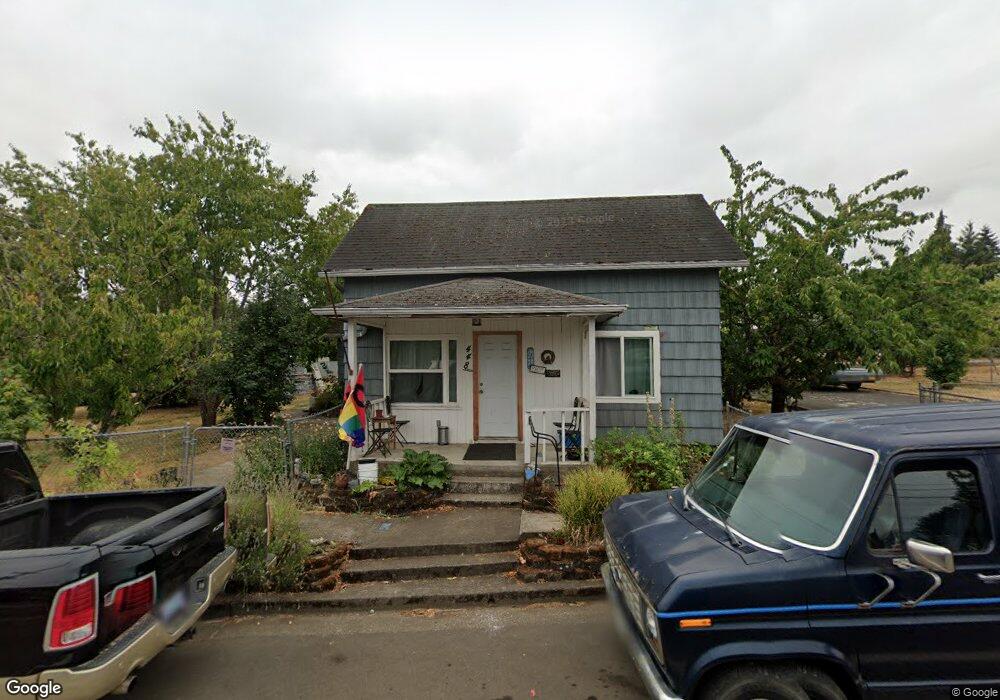
448 SW Mill St Sheridan, OR 97378
Estimated Value: $285,000 - $340,000
3
Beds
1
Bath
1,394
Sq Ft
$231/Sq Ft
Est. Value
About This Home
This home is located at 448 SW Mill St, Sheridan, OR 97378 and is currently estimated at $322,127, approximately $231 per square foot. 448 SW Mill St is a home located in Yamhill County with nearby schools including Faulconer-Chapman School, Sheridan High School, and Sheridan Allprep Academy.
Ownership History
Date
Name
Owned For
Owner Type
Purchase Details
Closed on
Jun 9, 2010
Sold by
Cole Kay E
Bought by
Hill Linda
Current Estimated Value
Home Financials for this Owner
Home Financials are based on the most recent Mortgage that was taken out on this home.
Original Mortgage
$130,880
Outstanding Balance
$88,243
Interest Rate
5.25%
Mortgage Type
FHA
Estimated Equity
$233,884
Create a Home Valuation Report for This Property
The Home Valuation Report is an in-depth analysis detailing your home's value as well as a comparison with similar homes in the area
Home Values in the Area
Average Home Value in this Area
Purchase History
| Date | Buyer | Sale Price | Title Company |
|---|---|---|---|
| Hill Linda | $137,900 | Western Title & Escrow | |
| Hill Linda | $137,900 | Western Title & Escrow |
Source: Public Records
Mortgage History
| Date | Status | Borrower | Loan Amount |
|---|---|---|---|
| Open | Hill Linda | $130,880 | |
| Closed | Hill Linda | $130,880 |
Source: Public Records
Tax History Compared to Growth
Tax History
| Year | Tax Paid | Tax Assessment Tax Assessment Total Assessment is a certain percentage of the fair market value that is determined by local assessors to be the total taxable value of land and additions on the property. | Land | Improvement |
|---|---|---|---|---|
| 2025 | $1,699 | $125,352 | -- | -- |
| 2024 | $1,560 | $121,701 | -- | -- |
| 2023 | $1,515 | $118,156 | $0 | $0 |
| 2022 | $1,473 | $114,715 | $0 | $0 |
| 2021 | $1,668 | $111,374 | $0 | $0 |
| 2020 | $1,611 | $108,130 | $0 | $0 |
| 2019 | $1,583 | $104,981 | $0 | $0 |
| 2018 | $1,538 | $101,923 | $0 | $0 |
| 2017 | $1,510 | $98,954 | $0 | $0 |
| 2016 | $1,466 | $96,072 | $0 | $0 |
| 2015 | $1,430 | $93,275 | $0 | $0 |
| 2014 | $1,391 | $90,560 | $0 | $0 |
Source: Public Records
Map
Nearby Homes
- 240 SW Jefferson St
- 617 SW Monroe St
- 735 SW Mill St
- 204 SW Water St
- 518 S Bridge St
- 370 NW Yamhill St
- 0 NW Viola St
- 328 NW Sherman St
- 740 SE Alicia St
- 243 SE Harney St
- 119 NW Sherman St
- 240 NW Sagan Loop
- 419 SE Sheridan Rd
- 503 SE Sheridan Rd Unit 8
- 0 Highway 18 (Ta 635db00400)
- 515 SE Sheridan Rd
- 515 SE Sheridan Rd Unit 6
- 634 E Main St
- 347 NE Oak St
- 1200 Blk NE Center St Unit Parcel 4
- 620 SW 4th St
- 512 SW Mill St
- 445 SW Mill St
- 434 SW Mill St
- 440 SW Madison St
- 517 SW Mill St
- 521 SW Jefferson St
- 526 SW Mill St
- 469 SW Jefferson St
- 424 SW Harrison St
- 416 SW Madison St
- 449 SW Jefferson St
- 409 SW Madison St
- 538 SW Mill St
- 549 SW Jefferson St
- 531 SW Mill St
- 418 SW Harrison St
- 480 SW Jefferson St
- 518 SW Jefferson St
- 411 SW Jefferson St