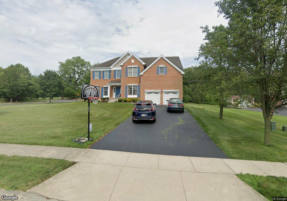
4481 Anthony Ct Bethlehem, PA 18020
Estimated Value: $707,523 - $807,000
4
Beds
3
Baths
3,547
Sq Ft
$220/Sq Ft
Est. Value
About This Home
This home is located at 4481 Anthony Ct, Bethlehem, PA 18020 and is currently estimated at $778,881, approximately $219 per square foot. 4481 Anthony Ct is a home located in Northampton County with nearby schools including East Hills Middle School, Freedom High School, and Bethlehem Christian School.
Ownership History
Date
Name
Owned For
Owner Type
Purchase Details
Closed on
Sep 7, 2005
Sold by
Toll Pennsylvania Iv
Bought by
Patel Harshad
Current Estimated Value
Home Financials for this Owner
Home Financials are based on the most recent Mortgage that was taken out on this home.
Original Mortgage
$300,000
Interest Rate
5.39%
Mortgage Type
New Conventional
Purchase Details
Closed on
Jan 29, 2002
Bought by
Toll Pa Iv Lp
Create a Home Valuation Report for This Property
The Home Valuation Report is an in-depth analysis detailing your home's value as well as a comparison with similar homes in the area
Home Values in the Area
Average Home Value in this Area
Purchase History
| Date | Buyer | Sale Price | Title Company |
|---|---|---|---|
| Patel Harshad | $504,575 | -- | |
| Toll Pa Iv Lp | $4,501,000 | -- |
Source: Public Records
Mortgage History
| Date | Status | Borrower | Loan Amount |
|---|---|---|---|
| Closed | Patel Harshad | $300,000 |
Source: Public Records
Tax History
| Year | Tax Paid | Tax Assessment Tax Assessment Total Assessment is a certain percentage of the fair market value that is determined by local assessors to be the total taxable value of land and additions on the property. | Land | Improvement |
|---|---|---|---|---|
| 2026 | $1,754 | $162,400 | $34,800 | $127,600 |
| 2025 | $1,754 | $162,400 | $34,800 | $127,600 |
| 2024 | $12,463 | $162,400 | $34,800 | $127,600 |
| 2023 | $12,503 | $162,400 | $34,800 | $127,600 |
| 2022 | $12,391 | $162,400 | $34,800 | $127,600 |
| 2021 | $12,295 | $162,400 | $34,800 | $127,600 |
| 2020 | $12,310 | $162,400 | $34,800 | $127,600 |
| 2019 | $12,263 | $162,400 | $34,800 | $127,600 |
| 2018 | $11,927 | $162,400 | $34,800 | $127,600 |
| 2017 | $11,845 | $162,400 | $34,800 | $127,600 |
| 2016 | -- | $162,400 | $34,800 | $127,600 |
| 2015 | -- | $162,400 | $34,800 | $127,600 |
| 2014 | -- | $162,400 | $34,800 | $127,600 |
Source: Public Records
Map
Nearby Homes
- 3868 Victors Way
- 3855 Victors Way
- 108 Brandywine Dr
- 4178 Rexford Dr
- 3814 Victors Way
- 3406 Church Rd
- 3801 Loyal Ln
- 3767 Founders Crossing
- 4008 Donegal Dr
- 4006 Easton Ave
- 3725 Oakland Rd
- 4141 Walter Rd
- 3951 Trythall St
- 4745 Bayard St
- 3909 Kipton Ct
- 3902 Orth St
- 3685 Manor Rd
- 3208 Oakland Square Dr
- 4014 Coleman St
- 4311 Tiffany Dr
- 4491 Anthony Ct
- 4471 Anthony Dr
- 4358 Rexford Dr
- 4501 Anthony Ct
- 4390 Anthony Ct
- 4349 Rexford Dr
- 4461 Anthony Dr
- 4348 Rexford Dr
- 4339 Rexford Dr
- 4350 Anthony Dr
- 4451 Anthony Dr
- 4340 Gordon St
- 4329 Rexford Dr
- 4338 Rexford Dr
- 4330 Gordon St
- 4349 Gordon St
- 4319 Rexford Dr
- 4441 Anthony Dr
- 4339 Gordon St
- 4190 Douglas Dr
Your Personal Tour Guide
Ask me questions while you tour the home.