


4481 Country Trail Unit 1 Gurnee, IL 60031
Estimated payment $3,024/month
Highlights
- Property is near a park
- Raised Ranch Architecture
- Main Floor Bedroom
- Woodland Elementary School Rated A-
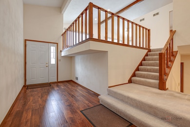
- Cathedral Ceiling
- 4-minute walk to O'Plaine Community Park
About This Home
Move-in ready and meticulously maintained! This spacious 4-bedroom, 3-bath bi-level home offers 2,814 sq. ft. of comfortable living and an attached 2-car garage. Key Features You'll Love: Expansive Living: Enjoy bright, airy living spaces, including a formal living room and dining room on the main level with stunning cathedral ceilings. Entertainer's Dream: The lower level boasts a huge 23x26 family room-perfect for gatherings-complete with a cozy wood-burning fireplace featuring a heatilator-type blower. Generous Bedrooms: Featuring four well-sized bedrooms (three on the main floor, one on the lower level) and three full bathrooms for ultimate convenience. Outdoor Retreats: Sliding doors off the dining room and master bedroom lead to inviting balcony/decks. The private backyard also includes a large concrete patio. Recent, High-Value Updates: This home has been thoughtfully updated with premium Marvin windows (front: double pane 2013; all others/sliding doors: mostly triple pane 2021) ensuring efficiency and peace of mind. Roof & Driveway: New in 2017. Exterior: Painted with two coats in 2018. Major Systems: AC (2015), 50-gallon water heater (2007), furnace (2007), with added gutter guards. Interior: New Hunter Douglas blinds installed in 2022. Prime Location: Enjoy the great outdoors with Betty Russell Park and the Des Plaines Trail access just a short walk away. This is the definition of move-in ready! Don't miss the opportunity to make this spectacular house your home. Schedule your viewing today!
Home Details
Home Type
- Single Family
Est. Annual Taxes
- $10,413
Year Built
- Built in 1984
Lot Details
- 9,583 Sq Ft Lot
- Lot Dimensions are 70x125
Parking
- 2 Car Garage
- Driveway
Home Design
- Raised Ranch Architecture
- Bi-Level Home
- Asphalt Roof
- Concrete Perimeter Foundation
Interior Spaces
- 2,814 Sq Ft Home
- Cathedral Ceiling
- Ceiling Fan
- Wood Burning Fireplace
- Heatilator
- Attached Fireplace Door
- Entrance Foyer
- Family Room with Fireplace
- Living Room
- L-Shaped Dining Room
- Carbon Monoxide Detectors
Kitchen
- Range with Range Hood
- Dishwasher
Flooring
- Carpet
- Vinyl
Bedrooms and Bathrooms
- 4 Bedrooms
- 4 Potential Bedrooms
- Main Floor Bedroom
- Bathroom on Main Level
- 3 Full Bathrooms
Laundry
- Laundry Room
- Dryer
- Washer
Basement
- Sump Pump
- Finished Basement Bathroom
Outdoor Features
- Balcony
- Patio
Location
- Property is near a park
Schools
- Woodland Elementary School
- Woodland Middle School
- Warren Township High School
Utilities
- Central Air
- Heating System Uses Natural Gas
- Gas Water Heater
- Cable TV Available
Community Details
- Country Trails Subdivision, Split Level Floorplan
Listing and Financial Details
- Homeowner Tax Exemptions
Map
Home Values in the Area
Average Home Value in this Area
Tax History
| Year | Tax Paid | Tax Assessment Tax Assessment Total Assessment is a certain percentage of the fair market value that is determined by local assessors to be the total taxable value of land and additions on the property. | Land | Improvement |
|---|---|---|---|---|
| 2024 | $9,051 | $118,121 | $17,427 | $100,694 |
| 2023 | $9,051 | $98,638 | $14,553 | $84,085 |
| 2022 | $9,331 | $100,183 | $14,549 | $85,634 |
| 2021 | $8,437 | $96,163 | $13,965 | $82,198 |
| 2020 | $8,163 | $93,800 | $13,622 | $80,178 |
| 2019 | $7,927 | $91,077 | $13,227 | $77,850 |
| 2018 | $8,186 | $94,063 | $12,998 | $81,065 |
| 2017 | $8,010 | $91,368 | $12,626 | $78,742 |
| 2016 | $7,942 | $87,300 | $12,064 | $75,236 |
| 2015 | $7,735 | $82,796 | $11,442 | $71,354 |
| 2014 | $7,497 | $80,952 | $11,984 | $68,968 |
| 2012 | $7,107 | $81,572 | $12,076 | $69,496 |
Property History
| Date | Event | Price | List to Sale | Price per Sq Ft |
|---|---|---|---|---|
| 12/12/2025 12/12/25 | For Sale | $409,900 | -- | $146 / Sq Ft |
Purchase History
| Date | Type | Sale Price | Title Company |
|---|---|---|---|
| Interfamily Deed Transfer | $142,000 | -- | |
| Interfamily Deed Transfer | -- | -- |
Mortgage History
| Date | Status | Loan Amount | Loan Type |
|---|---|---|---|
| Closed | $142,000 | No Value Available |
Source: Midwest Real Estate Data (MRED)
MLS Number: 12532286
APN: 07-26-207-002
Disclaimer: Certain information contained herein is derived from information provided by parties other than Homes.com. All information provided is deemed reliable, but is not guaranteed to be accurate and should be independently verified.
![]() Based on information submitted to the MLS GRID. All data is obtained from various sources and may not have been verified by broker or MLS GRID. Supplied Open House Information is subject to change without notice. All information should be independently reviewed and verified for accuracy. Properties may or may not be listed by the office/agent presenting the information. Some IDX listings have been excluded from this website.
Based on information submitted to the MLS GRID. All data is obtained from various sources and may not have been verified by broker or MLS GRID. Supplied Open House Information is subject to change without notice. All information should be independently reviewed and verified for accuracy. Properties may or may not be listed by the office/agent presenting the information. Some IDX listings have been excluded from this website.
The Digital Millennium Copyright Act of 1998, 17 U.S.C. § 512 (the “DMCA”) provides recourse for copyright owners who believe that material appearing on the Internet infringes their rights under U.S. copyright law. If you believe in good faith that any content or material made available in connection with our website or services infringes your copyright, you (or your agent) may send us a notice requesting that the content or material be removed, or access to it blocked.
Notices must be sent in writing by email to DMCAnotice@MLSGrid.com.
The DMCA requires that your notice of alleged copyright infringement include the following information:
(1) description of the copyrighted work that is the subject of claimed infringement;
(2) description of the alleged infringing content and information sufficient to permit us to locate the content;
(3) contact information for you, including your address, telephone number and email address;
(4) a statement by you that you have a good faith belief that the content in the manner complained of is not authorized by the copyright owner, or its agent, or by the operation of any law;
(5) a statement by you, signed under penalty of perjury, that the information in the notification is accurate and that you have the authority to enforce the copyrights that are claimed to be infringed; and
(6) a physical or electronic signature of the copyright owner or a person authorized to act on the copyright owner’s behalf. Failure to include all of the above information may result in the delay of the processing of your complaint.
- 450 Tanglewood Dr
- 662 Waterbury Ave
- 4837 Middle Rd
- 543 Long Hill Rd
- 4437-4495 W Kennedy Dr
- 4506 W Forest Ave
- 93 Berkshire Ct Unit D
- 33564 Greenleaf St
- 4471 Brighton Ct Unit 7
- 0 Northwoods Ave Unit MRD11938775
- 00 Northwood Ave
- 287 Kensington Ct Unit 4
- 4520 W Lawn Ave
- 424 Greenview Dr
- 3910 Ingleside Ave
- 4390 W Parkway Ave
- 3810 1st St
- 3947 Blackstone Ave
- 1389 S Candlestick Way
- 601 Lakehurst Rd
- 4553 W Hill Ave
- 926 S West Ave
- 4439 W Lawn Ave
- 149 Woodlake Blvd Unit ID1228632P
- 500 Lakehurst Rd
- 101 Woodlake Blvd
- 1 Woodlake Blvd
- 4344 Mcclure Ave
- 600 Creekside Cir Unit 85
- 1534 S Falcon Dr
- 3964 Grandview Ave Unit ID1265534P
- 1375 S White Oak Dr
- 651 White Ct
- 633 Chip Ct Unit U269
- 691 Wakefield Rd Unit 691
- 3060 Kathe Ln
- 300-336 N Green Bay Rd
- 922 N Green Bay Rd Unit A05C
- 5389 Lezlie Ln
- 1800 Wedgewood Dr
