Estimated Value: $450,000 - $487,384
3
Beds
2
Baths
1,663
Sq Ft
$278/Sq Ft
Est. Value
About This Home
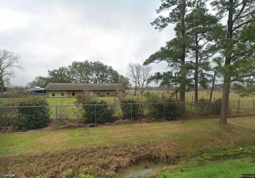
This home is located at 4483 Cr 181, Alvin, TX 77511 and is currently estimated at $462,795, approximately $278 per square foot. 4483 Cr 181 is a home located in Brazoria County with nearby schools including Bob & Betty Nelson Elementary School, Fairview Junior High School, and Alvin High School.
Ownership History
Date
Name
Owned For
Owner Type
Purchase Details
Closed on
Feb 24, 2011
Sold by
Rivera Roberto
Bought by
Colvin Barbara Irene
Current Estimated Value
Purchase Details
Closed on
Jan 26, 2011
Sold by
Tucker Scott Wayne and Tucker Renee
Bought by
Rivera Roberto
Purchase Details
Closed on
Jun 29, 2010
Sold by
Carlisle Stephanie Kay
Bought by
Tucker Scott Wayne
Home Financials for this Owner
Home Financials are based on the most recent Mortgage that was taken out on this home.
Original Mortgage
$243,802
Interest Rate
4.81%
Mortgage Type
VA
Purchase Details
Closed on
May 20, 2004
Sold by
Ware Charles W
Bought by
Carlisle Stephanie Kay
Home Financials for this Owner
Home Financials are based on the most recent Mortgage that was taken out on this home.
Original Mortgage
$196,000
Interest Rate
5.93%
Mortgage Type
Purchase Money Mortgage
Create a Home Valuation Report for This Property
The Home Valuation Report is an in-depth analysis detailing your home's value as well as a comparison with similar homes in the area
Home Values in the Area
Average Home Value in this Area
Purchase History
| Date | Buyer | Sale Price | Title Company |
|---|---|---|---|
| Colvin Barbara Irene | -- | South Land Title Llc | |
| Rivera Roberto | -- | South Land Title Llc | |
| Tucker Scott Wayne | -- | Stewart Title Company | |
| Carlisle Stephanie Kay | -- | American Title Co |
Source: Public Records
Mortgage History
| Date | Status | Borrower | Loan Amount |
|---|---|---|---|
| Previous Owner | Tucker Scott Wayne | $243,802 | |
| Previous Owner | Carlisle Stephanie Kay | $196,000 |
Source: Public Records
Tax History Compared to Growth
Tax History
| Year | Tax Paid | Tax Assessment Tax Assessment Total Assessment is a certain percentage of the fair market value that is determined by local assessors to be the total taxable value of land and additions on the property. | Land | Improvement |
|---|---|---|---|---|
| 2025 | $7,280 | $489,013 | $251,780 | $237,233 |
| 2023 | $7,280 | $434,998 | $251,780 | $230,760 |
| 2022 | $8,426 | $395,453 | $220,310 | $218,600 |
| 2021 | $7,978 | $409,830 | $204,580 | $205,250 |
| 2020 | $7,350 | $361,000 | $188,840 | $172,160 |
| 2019 | $6,878 | $297,110 | $102,520 | $194,590 |
| 2018 | $8,218 | $354,090 | $129,500 | $224,590 |
| 2017 | $7,887 | $354,790 | $124,100 | $230,690 |
| 2016 | $7,170 | $305,230 | $81,540 | $223,690 |
| 2015 | $6,647 | $274,440 | $67,950 | $206,490 |
| 2014 | $6,647 | $280,800 | $67,950 | $212,850 |
Source: Public Records
Map
Nearby Homes
- 1682 Herring Rd
- 925 County Road 737b
- 4901 Highway 6
- 3245 W Highway 6
- 0 Schroeder Lane B
- 10618 County Road 583b
- 0 County Road 169 Off Nar
- 3293 County Road 181
- 2703 County Road 962d
- 2518 W Highway 6
- 1259 County Road 147
- 2386 Mamie Ford Rd
- 418 Riesling Dr
- 407 Riesling Dr
- 422 Riesling Dr
- 426 Riesling Dr
- 23522 Malbec Dr
- 318 Merlot Dr
- Emerson Plan at Martha's Vineyard
- Silverthorne Plan at Martha's Vineyard
- 4483 County Road 181
- 4403 County Road 181
- 4428 County Road 181 Unit 18
- 4404 County Road 181
- 4579 County Road 181
- 4357 County Road 181
- 4528 County Road 181
- 4566 County Road 181
- 181 County Road 181
- 4315 County Road 181
- 4315 County Road 181
- 4316 County Road 181
- 4643 County Road 181
- 4295 County Road 181
- 4646 County Road 181
- 4913 County Road 937a
- 4903 County Road 937b
- 4522 County Road 138a
- 4782 County Road 138
- 4782 Cr 138