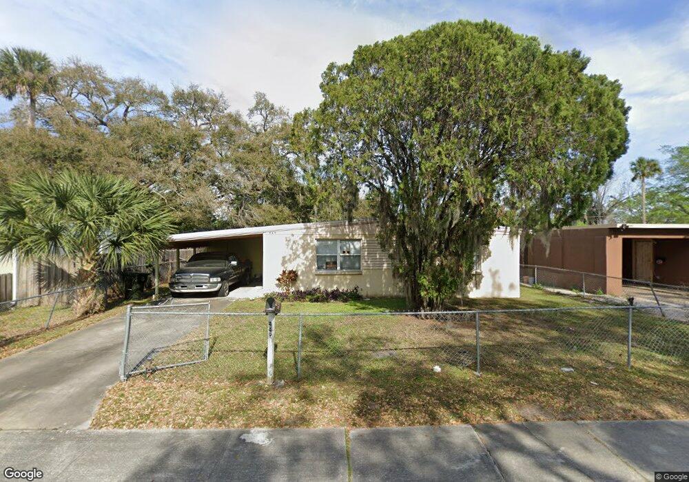
449 Lockhart St Daytona Beach, FL 32114
Central Daytona NeighborhoodEstimated Value: $134,999 - $185,000
1
Bed
1
Bath
748
Sq Ft
$208/Sq Ft
Est. Value
About This Home
This home is located at 449 Lockhart St, Daytona Beach, FL 32114 and is currently estimated at $155,750, approximately $208 per square foot. 449 Lockhart St is a home located in Volusia County with nearby schools including Turie T. Small Elementary School, Spruce Creek Elementary School, and Campbell Middle School.
Ownership History
Date
Name
Owned For
Owner Type
Purchase Details
Closed on
Mar 11, 2020
Sold by
Jones Edith W
Bought by
Jones Edith W
Current Estimated Value
Purchase Details
Closed on
Jan 19, 2017
Sold by
Jones Arthur J
Bought by
Jones Edth W
Purchase Details
Closed on
Apr 12, 2007
Sold by
Jones Arthur and Jones Edith W
Bought by
Jones Arthur and Jones Edith W
Purchase Details
Closed on
Sep 15, 1976
Bought by
Jones Arthur J
Create a Home Valuation Report for This Property
The Home Valuation Report is an in-depth analysis detailing your home's value as well as a comparison with similar homes in the area
Home Values in the Area
Average Home Value in this Area
Purchase History
| Date | Buyer | Sale Price | Title Company |
|---|---|---|---|
| Jones Edith W | -- | Attorney | |
| Jones Edth W | -- | Attorney | |
| Jones Arthur | -- | Attorney | |
| Jones Arthur J | $19,800 | -- |
Source: Public Records
Tax History Compared to Growth
Tax History
| Year | Tax Paid | Tax Assessment Tax Assessment Total Assessment is a certain percentage of the fair market value that is determined by local assessors to be the total taxable value of land and additions on the property. | Land | Improvement |
|---|---|---|---|---|
| 2025 | $1,258 | $109,836 | $20,580 | $89,256 |
| 2024 | $1,258 | $110,487 | $20,580 | $89,907 |
| 2023 | $1,258 | $102,425 | $20,580 | $81,845 |
| 2022 | $1,008 | $65,387 | $16,170 | $49,217 |
| 2021 | $911 | $48,594 | $12,936 | $35,658 |
| 2020 | $856 | $48,683 | $12,936 | $35,747 |
| 2019 | $767 | $40,227 | $5,640 | $34,587 |
| 2018 | $733 | $38,450 | $5,640 | $32,810 |
| 2017 | $674 | $31,762 | $4,212 | $27,550 |
| 2016 | $645 | $28,985 | $0 | $0 |
| 2015 | $645 | $27,579 | $0 | $0 |
| 2014 | $643 | $27,250 | $0 | $0 |
Source: Public Records
Map
Nearby Homes
- 437 Lockhart St
- 425 Lockhart St
- 812 Kottle Cir S
- 812 Kottle Cir S Unit S
- 809 Maley St
- 835 Kottle Cir N Unit N
- 835 Kottle Cir N
- 825 Kottle Cir S
- 716 Verdell St
- 317 Reva St
- 704 Park Dr
- 635 Mccormick St
- 241 S Franklin St
- 710 Orange Ave
- 643 Mc Cormick St
- 0 Orange Ave
- 616 Cedar Park Dr
- 704 Cedar St
- 638 Orange Ave
- 241 Martin Luther King Blvd S
- 445 Lockhart St
- 453 Lockhart St
- 448 Alamanda St
- 452 Alamanda St
- 444 Alamanda St
- 441 Lockhart St
- 457 Lockhart St
- 800 Kottle Cir S
- 440 Alamanda St
- 456 Alamanda St
- 461 Lockhart St
- 460 Alamanda St
- 805 Kottle Cir N
- 433 Lockhart St
- 449 Alamanda St
- 445 Alamanda St
- 432 Alamanda Dr
- 453 Alamanda St
- 330 Loomis Ave
- 00 Loomis Ave