Estimated Value: $371,070 - $540,000
3
Beds
2
Baths
1,820
Sq Ft
$242/Sq Ft
Est. Value
About This Home
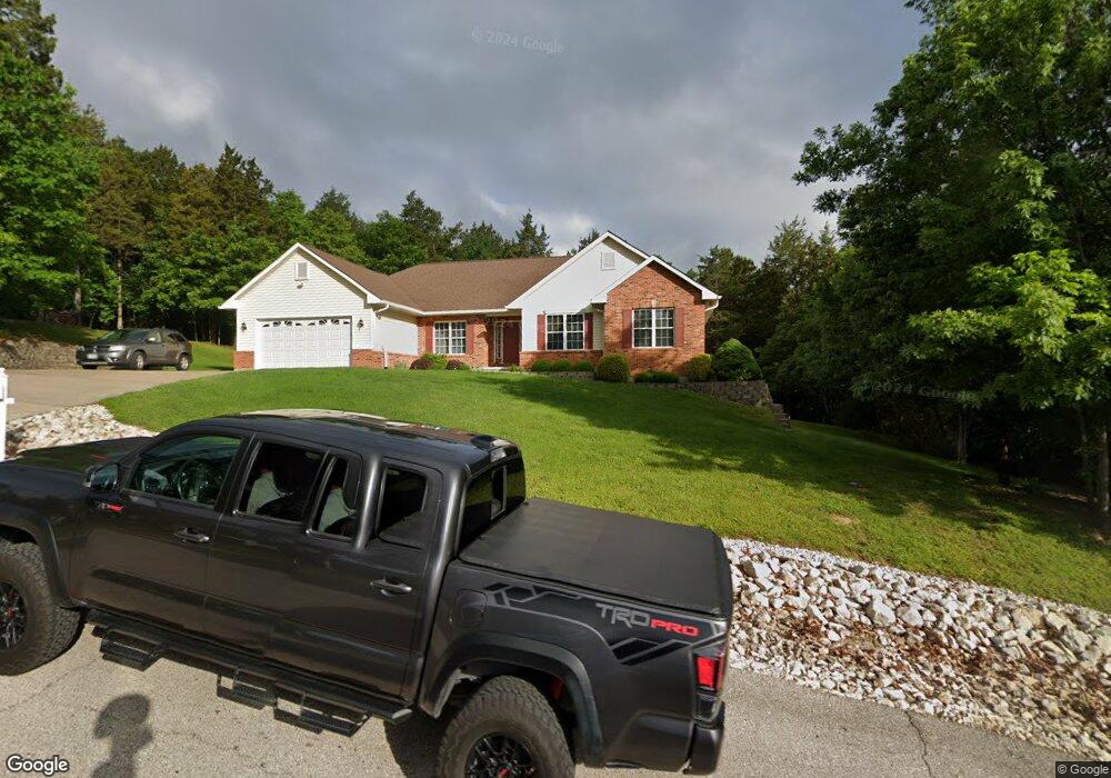
This home is located at 449 Mark Twain Loop, Union, MO 63084 and is currently estimated at $441,023, approximately $242 per square foot. 449 Mark Twain Loop is a home located in Franklin County with nearby schools including Union High School and St. Gertrude Catholic School.
Ownership History
Date
Name
Owned For
Owner Type
Purchase Details
Closed on
Aug 5, 2008
Sold by
Clark Maria C
Bought by
Burgess Lawrence J and Burgess Andrea
Current Estimated Value
Home Financials for this Owner
Home Financials are based on the most recent Mortgage that was taken out on this home.
Original Mortgage
$187,200
Outstanding Balance
$114,292
Interest Rate
5.12%
Mortgage Type
Assumption
Estimated Equity
$326,731
Purchase Details
Closed on
Jun 10, 2008
Sold by
Clark James P
Bought by
Clark Maria C
Home Financials for this Owner
Home Financials are based on the most recent Mortgage that was taken out on this home.
Original Mortgage
$187,200
Outstanding Balance
$114,292
Interest Rate
5.12%
Mortgage Type
Assumption
Estimated Equity
$326,731
Create a Home Valuation Report for This Property
The Home Valuation Report is an in-depth analysis detailing your home's value as well as a comparison with similar homes in the area
Purchase History
| Date | Buyer | Sale Price | Title Company |
|---|---|---|---|
| Burgess Lawrence J | -- | None Available | |
| Clark Maria C | -- | None Available |
Source: Public Records
Mortgage History
| Date | Status | Borrower | Loan Amount |
|---|---|---|---|
| Open | Burgess Lawrence J | $187,200 |
Source: Public Records
Tax History
| Year | Tax Paid | Tax Assessment Tax Assessment Total Assessment is a certain percentage of the fair market value that is determined by local assessors to be the total taxable value of land and additions on the property. | Land | Improvement |
|---|---|---|---|---|
| 2025 | $2,530 | $47,905 | $0 | $0 |
| 2024 | $2,530 | $39,839 | $0 | $0 |
| 2023 | $2,126 | $39,839 | $0 | $0 |
| 2022 | $2,357 | $44,053 | $0 | $0 |
| 2021 | $2,361 | $44,053 | $0 | $0 |
| 2020 | $2,137 | $39,296 | $0 | $0 |
| 2019 | $2,131 | $39,296 | $0 | $0 |
| 2018 | $1,961 | $38,323 | $0 | $0 |
| 2017 | $1,968 | $38,323 | $0 | $0 |
| 2016 | $1,938 | $36,778 | $0 | $0 |
| 2015 | $1,904 | $36,778 | $0 | $0 |
| 2014 | $1,930 | $37,114 | $0 | $0 |
Source: Public Records
Map
Nearby Homes
- 430 Mark Twain Loop
- 405 Mark Twain Loop
- 421 Park Ln
- 6560 Highway Bb
- 301 Park Place Dr
- 7195 Highway Aj
- 219 Fawn Dr
- 541 Rock Creek Dr
- 0 Heard Ct
- 54 Hickory Cir
- 21 Forest Ln
- 626 Lindsey Dr
- 406 Emma Ln
- 914 W State St
- 4 Lindner Ln
- 26 & 30 Ridge Point Meadows
- 3732 Highway A
- 130 Rolling Hills Dr
- 1552 Clearview Rd
- 725 W Main St
- 732 Tom Sawyer Ct
- 708 Tom Sawyer Ct
- 448 Mark Twain Loop
- 454 Mark Twain Loop
- 436 Mark Twain Loop
- 720 Tom Sawyer Ct
- 442 Mark Twain Loop
- 0LOT 68 Mark Twain Loop
- 518 Huckelberry Ct
- 431 Mark Twain Loop
- 0LOT 80 Tom Sawyer Ct
- 0LOT 79 Tom Sawyer Ct
- 506 Huckelberry Ct
- 453 Mark Twain Loop
- 500 Huckelberry Ct
- 524 Huckelberry Ct
- 731 Tom Sawyer Ct
- 707 Tom Sawyer Ct
- 725 Tom Sawyer Ct
Your Personal Tour Guide
Ask me questions while you tour the home.