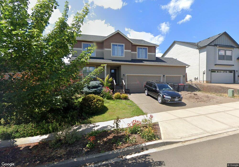
449 SW Mt Adams St McMinnville, OR 97128
Estimated Value: $590,722 - $645,000
5
Beds
3
Baths
2,213
Sq Ft
$277/Sq Ft
Est. Value
About This Home
This home is located at 449 SW Mt Adams St, McMinnville, OR 97128 and is currently estimated at $613,681, approximately $277 per square foot. 449 SW Mt Adams St is a home located in Yamhill County with nearby schools including Willamette Elementary School, Duniway Middle School, and McMinnville High School.
Ownership History
Date
Name
Owned For
Owner Type
Purchase Details
Closed on
Dec 27, 2016
Sold by
Premier Home Builders Inc
Bought by
Happ Scott T and Happ Kathryn J
Current Estimated Value
Purchase Details
Closed on
Jul 13, 2016
Sold by
Premier Development Llc
Bought by
Premier Home Builders Inc
Home Financials for this Owner
Home Financials are based on the most recent Mortgage that was taken out on this home.
Original Mortgage
$260,588
Interest Rate
3.6%
Mortgage Type
Unknown
Create a Home Valuation Report for This Property
The Home Valuation Report is an in-depth analysis detailing your home's value as well as a comparison with similar homes in the area
Home Values in the Area
Average Home Value in this Area
Purchase History
| Date | Buyer | Sale Price | Title Company |
|---|---|---|---|
| Happ Scott T | $349,900 | First American Title | |
| Premier Home Builders Inc | -- | None Available |
Source: Public Records
Mortgage History
| Date | Status | Borrower | Loan Amount |
|---|---|---|---|
| Previous Owner | Premier Home Builders Inc | $260,588 |
Source: Public Records
Tax History Compared to Growth
Tax History
| Year | Tax Paid | Tax Assessment Tax Assessment Total Assessment is a certain percentage of the fair market value that is determined by local assessors to be the total taxable value of land and additions on the property. | Land | Improvement |
|---|---|---|---|---|
| 2024 | $4,812 | $276,840 | -- | -- |
| 2023 | $4,543 | $268,777 | $0 | $0 |
| 2022 | $4,304 | $260,949 | $0 | $0 |
| 2021 | $4,202 | $253,349 | $0 | $0 |
| 2020 | $4,168 | $245,970 | $0 | $0 |
| 2019 | $4,055 | $238,806 | $0 | $0 |
| 2018 | $3,975 | $231,850 | $0 | $0 |
| 2017 | $3,837 | $225,097 | $0 | $0 |
| 2016 | $0 | $0 | $0 | $0 |
Source: Public Records
Map
Nearby Homes
- 459 SW Howard Dr
- 295 SW Mount Saint Helens St
- 348 SW Mt Rainier St
- 197 SW Howard Dr
- 398 SW Mt Mazama St
- 2317 SW Peggy St
- 177 SW Mt Mazama St
- 2650 NW Mt Ashland Dr
- 225 SW Valleys Edge St
- 2683 NW Mt Hood Dr
- 525 NW Hillcrest Loop
- 2805 NW Mount Ashland Ln
- 2898 NW Mount Ashland Ln
- 117 NW Canyon Creek Dr
- 2362 NW Wintergreen Ct
- 2010 SW Fellows St
- 280 NW Country Ct
- 2598 NW Meadows Dr
- 1154 SW Emma Dr
- 2031 SW Alexandria St
- 365 SW Mt Adams St
- 417 SW Mt Adams St
- 465 SW Mt Adams St
- 452 SW Mount Saint Helens St
- 483 SW Mt Adams St
- 395 SW Mt Adams St
- 476 SW Mount Saint Helens St
- 424 SW Mount Saint Helens St
- 454 SW Mt Adams St
- 472 SW Mt Adams St
- 484 SW Mt St Helens St
- 396 SW Mount Saint Helens St
- 406 SW Mt Adams St
- 387 SW Mount Adams St
- 491 SW Mt Adams St
- 486 SW Mt Adams St
- 378 SW Mount Saint Helens St
- 441 SW Howard Dr
- 496 SW Mt St Helens St
- 364 SW Mt Adams St