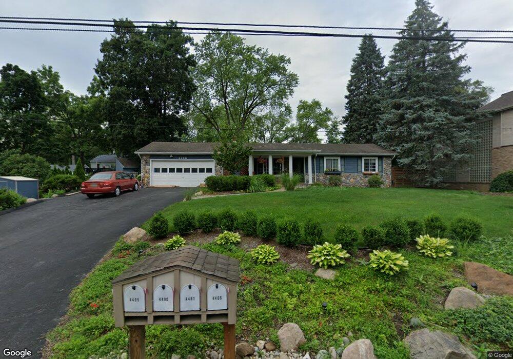
4490 Borland St West Bloomfield, MI 48323
Estimated Value: $278,795 - $303,000
3
Beds
1
Bath
1,018
Sq Ft
$289/Sq Ft
Est. Value
About This Home
This home is located at 4490 Borland St, West Bloomfield, MI 48323 and is currently estimated at $294,449, approximately $289 per square foot. 4490 Borland St is a home located in Oakland County with nearby schools including Walled Lake Central High School, The Susan And Rabbi Harold Loss Ecc, and Brookfield Academy - West Bloomfield.
Ownership History
Date
Name
Owned For
Owner Type
Purchase Details
Closed on
Jul 18, 2014
Sold by
Nagy Stephen W and Nagy Kimber L
Bought by
Hanson John P and Hanson Joanna
Current Estimated Value
Home Financials for this Owner
Home Financials are based on the most recent Mortgage that was taken out on this home.
Original Mortgage
$14,723,100
Outstanding Balance
$11,231,399
Interest Rate
4.2%
Mortgage Type
FHA
Estimated Equity
-$10,936,950
Purchase Details
Closed on
Aug 26, 2009
Sold by
Nagy Stephen W and Stephen W Nagy Trust
Bought by
Nagy Stephen W and Nagy Kimber L
Purchase Details
Closed on
Dec 18, 2002
Sold by
Nbagy Diane L
Bought by
Stpehen W Nagy Tr
Purchase Details
Closed on
Mar 3, 1997
Sold by
Nagy Stephen Wayne
Bought by
Stephen W Nagy Tr
Create a Home Valuation Report for This Property
The Home Valuation Report is an in-depth analysis detailing your home's value as well as a comparison with similar homes in the area
Home Values in the Area
Average Home Value in this Area
Purchase History
| Date | Buyer | Sale Price | Title Company |
|---|---|---|---|
| Hanson John P | $155,000 | Sun Title Agency | |
| Nagy Stephen W | -- | First American Title Ins Co | |
| Stpehen W Nagy Tr | -- | -- | |
| Stephen W Nagy Tr | -- | -- |
Source: Public Records
Mortgage History
| Date | Status | Borrower | Loan Amount |
|---|---|---|---|
| Open | Hanson John P | $14,723,100 |
Source: Public Records
Tax History Compared to Growth
Tax History
| Year | Tax Paid | Tax Assessment Tax Assessment Total Assessment is a certain percentage of the fair market value that is determined by local assessors to be the total taxable value of land and additions on the property. | Land | Improvement |
|---|---|---|---|---|
| 2024 | $2,125 | $115,680 | $0 | $0 |
| 2022 | $2,004 | $110,210 | $48,930 | $61,280 |
| 2021 | $3,296 | $106,830 | $0 | $0 |
| 2020 | $1,980 | $103,460 | $48,930 | $54,530 |
| 2018 | $3,208 | $94,970 | $50,240 | $44,730 |
| 2015 | -- | $87,810 | $0 | $0 |
| 2014 | -- | $82,460 | $0 | $0 |
| 2011 | -- | $76,350 | $0 | $0 |
Source: Public Records
Map
Nearby Homes
- 4442 Borland St
- 6980 Hambro St
- 4066 Green Lake Rd
- 6978 Colony Dr
- 4245 Bunker Ave
- 3991 Fieldview Ave
- 3965 Carrick Ave
- 3950 Bradmore Ave
- 6903 Dandison Blvd
- 7381 Crestmore St
- 6768 Buckland Ave
- 7359 Woodlore Dr
- 7065 Deerwood Trail Unit 27
- 7545/7585 Pontiac Trail
- 7585/7548 Pontiac Trail
- 6140 Pontiac Trail
- 000 Pontiac Trail
- 6100 Pontiac Trail
- 5994 Glen Eagles Dr
- 3655 Walnut
- 4466 Borland St
- 4510 Borland St
- 4495 Bethune Ct
- 4485 Bethune Ct
- 4495 Borland St
- 4481 Borland St
- 4505 Bethune Ct
- 4454 Borland St
- 4465 Bethune Ct
- 4515 Borland St
- 4520 Borland St
- 4459 Bethune Ct
- 4461 Borland St
- 4490 Bethune Ct
- 4535 Bethune Ct
- 4480 Bethune Ct
- 4403 Rolling Pine Dr
- 4409 Rolling Pine Dr
- 4510 Bethune Ct
- 4470 Bethune Ct