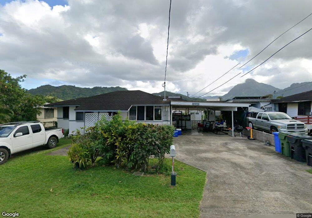
45-320 Makalani St Kaneohe, HI 96744
Estimated Value: $893,651 - $1,110,000
3
Beds
1
Bath
804
Sq Ft
$1,249/Sq Ft
Est. Value
About This Home
This home is located at 45-320 Makalani St, Kaneohe, HI 96744 and is currently estimated at $1,004,413, approximately $1,249 per square foot. 45-320 Makalani St is a home located in Honolulu County with nearby schools including Puohala Elementary School, Governor Samuel Wilder King Intermediate School, and Castle High School.
Ownership History
Date
Name
Owned For
Owner Type
Purchase Details
Closed on
Jan 15, 2025
Sold by
Tongg Sheri Lee Ann and Tongg David Barten
Bought by
Tongg David Barten and Tongg Sheri Lee
Current Estimated Value
Purchase Details
Closed on
Jan 2, 2018
Sold by
Tongg Sheri Lee Ann and Gladys Fusako Yap Revocable Tr
Bought by
Yoshikawa Teri Lynn Sue and Tongg Sheri Lee Ann
Purchase Details
Closed on
May 16, 2014
Sold by
Yap Gladys Fujimoto and Yap Gladys Fusako
Bought by
Yap Gladys Fusako
Purchase Details
Closed on
Oct 5, 2004
Sold by
Bishop Museum
Bought by
Yap Gladys Fujimoto
Create a Home Valuation Report for This Property
The Home Valuation Report is an in-depth analysis detailing your home's value as well as a comparison with similar homes in the area
Home Values in the Area
Average Home Value in this Area
Purchase History
| Date | Buyer | Sale Price | Title Company |
|---|---|---|---|
| Tongg David Barten | -- | None Listed On Document | |
| Tongg David Barten | -- | None Listed On Document | |
| Yoshikawa Teri Lynn Sue | -- | None Available | |
| Yoshikawa Teri Lynn Sue | -- | None Available | |
| Yap Gladys Fusako | -- | None Available | |
| Yap Gladys Fusako | -- | None Available | |
| Yap Gladys Fujimoto | -- | -- |
Source: Public Records
Tax History Compared to Growth
Tax History
| Year | Tax Paid | Tax Assessment Tax Assessment Total Assessment is a certain percentage of the fair market value that is determined by local assessors to be the total taxable value of land and additions on the property. | Land | Improvement |
|---|---|---|---|---|
| 2025 | $3,124 | $987,400 | $863,200 | $124,200 |
| 2024 | $3,124 | $892,600 | $810,700 | $81,900 |
| 2023 | $3,233 | $923,600 | $810,700 | $112,900 |
| 2022 | $2,925 | $835,600 | $735,600 | $100,000 |
| 2021 | $2,710 | $774,300 | $675,500 | $98,800 |
| 2020 | $2,693 | $769,400 | $675,500 | $93,900 |
| 2019 | $2,672 | $763,400 | $660,500 | $102,900 |
| 2018 | $2,343 | $669,500 | $586,200 | $83,300 |
| 2017 | $2,012 | $694,900 | $526,100 | $168,800 |
| 2016 | $1,776 | $627,400 | $488,500 | $138,900 |
| 2015 | $1,300 | $491,500 | $451,800 | $39,700 |
| 2014 | -- | $520,800 | $413,300 | $107,500 |
Source: Public Records
Map
Nearby Homes
- 45-456 Ihilani St
- 45-38 Holowai Place
- 1 Kamehameha Hwy
- 45-756 Kamehameha Hwy
- 45-702 Kolokio Place
- 45-333 Mahalani St
- 45-532 Kapalai Rd
- 45-20 Namoku St
- 45-995 Wailele Rd Unit 55
- 45-995 Wailele Rd Unit 35
- 45-995 Wailele Rd Unit 29
- 45-995 Wailele Rd Unit 8
- 45-210 Kailiwai Place
- 45-433 Akimala St
- 45-340 Lehuuila St
- 45-535 Luluku Rd Unit J5
- 45-535 Luluku Rd Unit K2
- 45-535 Luluku Rd Unit K4
- 45-535 Luluku Rd Unit A53
- 45-535 Luluku Rd Unit A23
- 45-316 Makalani St
- 45-324 Makalani St
- 45-321 Kulauli St
- 45-325 Kulauli St
- 45-317 Kulauli St
- 45-328 Makalani St
- 45-314 Makalani St
- 45-319 Makalani St
- 45-323 Makalani St
- 45-315 Kulauli St
- 45-315 Makalani St
- 45-329 Kulauli St
- 45-310 Makalani St
- 45-330 Makalani St
- 45-327 Makalani St
- 45-311 Kulauli St
- 45-333 Kulauli St
- 45-324 Kulauli St
- 45-320 Kulauli St
- 45-309 Makalani St