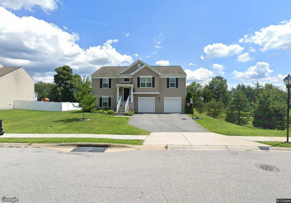
45 Amicus St Taneytown, MD 21787
Estimated Value: $368,000 - $441,000
Studio
--
Bath
1,474
Sq Ft
$267/Sq Ft
Est. Value
About This Home
This home is located at 45 Amicus St, Taneytown, MD 21787 and is currently estimated at $393,055, approximately $266 per square foot. 45 Amicus St is a home located in Carroll County with nearby schools including Runnymede Elementary School, Northwest Middle School, and Francis Scott Key High School.
Ownership History
Date
Name
Owned For
Owner Type
Purchase Details
Closed on
Dec 28, 2015
Sold by
Bob Ward New Homes At Carroll County Llc
Bought by
Sims Arthur W and Sims Amanda L
Current Estimated Value
Home Financials for this Owner
Home Financials are based on the most recent Mortgage that was taken out on this home.
Original Mortgage
$271,465
Outstanding Balance
$215,902
Interest Rate
3.96%
Mortgage Type
New Conventional
Estimated Equity
$177,153
Purchase Details
Closed on
Jul 23, 2015
Sold by
Taneytown Ventures Llc
Bought by
Bob Ward New Homes At Carroll Llc
Create a Home Valuation Report for This Property
The Home Valuation Report is an in-depth analysis detailing your home's value as well as a comparison with similar homes in the area
Purchase History
| Date | Buyer | Sale Price | Title Company |
|---|---|---|---|
| Sims Arthur W | $260,770 | Stewart Title Guaranty Co | |
| Bob Ward New Homes At Carroll Llc | $225,000 | Residential Title & Escrow C |
Source: Public Records
Mortgage History
| Date | Status | Borrower | Loan Amount |
|---|---|---|---|
| Open | Sims Arthur W | $271,465 |
Source: Public Records
Tax History
| Year | Tax Paid | Tax Assessment Tax Assessment Total Assessment is a certain percentage of the fair market value that is determined by local assessors to be the total taxable value of land and additions on the property. | Land | Improvement |
|---|---|---|---|---|
| 2025 | $4,659 | $318,733 | $0 | $0 |
| 2024 | $4,419 | $299,867 | $0 | $0 |
| 2023 | $4,186 | $281,000 | $90,300 | $190,700 |
| 2022 | $4,082 | $273,967 | $0 | $0 |
| 2021 | $8,008 | $266,933 | $0 | $0 |
| 2020 | $3,898 | $259,900 | $90,300 | $169,600 |
| 2019 | $3,824 | $254,900 | $0 | $0 |
| 2018 | $3,723 | $249,900 | $0 | $0 |
| 2017 | $3,649 | $244,900 | $0 | $0 |
| 2016 | -- | $244,900 | $0 | $0 |
| 2015 | -- | $70,300 | $0 | $0 |
| 2014 | -- | $72,300 | $0 | $0 |
Source: Public Records
Map
Nearby Homes
- 4315 Stumptown Rd
- 94 Kenan St
- 545 Daisy Dr
- 19 Fairground Ave
- 423 Clover Ct
- 417 Red Tulip Ct
- 411 Clover Ct
- 428 E Baltimore St
- 405 Clubside Dr
- 413 Clubside Dr
- 102 Butterfly Dr
- 101 Butterfly Dr
- 0 Carnival Dr
- 17 Hayride Ln
- 8 Hayride Ln
- 33 Musket Ct
- 314 Butterfly Dr
- 316 Taney Dr
- 404 Taney Dr
- 172 Saddletop Dr
- 47 Amicus St
- 44 Amicus St
- 49 Amicus St
- 4323 Stumptown Rd
- 42 Amicus St
- 0 Amicus St Unit 1007888032
- 0 Amicus St Unit 1007195844
- 0 Amicus St Unit 1007120636
- 0 Amicus St Unit 1007115112
- 0 Amicus St Unit 1007085332
- 0 Amicus St Unit 1007061780
- 0 Amicus St Unit 1007046762
- 0 Amicus St Unit 1007007280
- 0 Amicus St Unit 1006988224
- 0 Amicus St Unit 1006970748
- 0 Amicus St Unit 1006951862
- 0 Amicus St Unit 1006934880
- 0 Amicus St Unit CR7824327
- 0 Amicus St Unit CR7824308
- 0 Amicus St Unit CR7824294
Your Personal Tour Guide
Ask me questions while you tour the home.