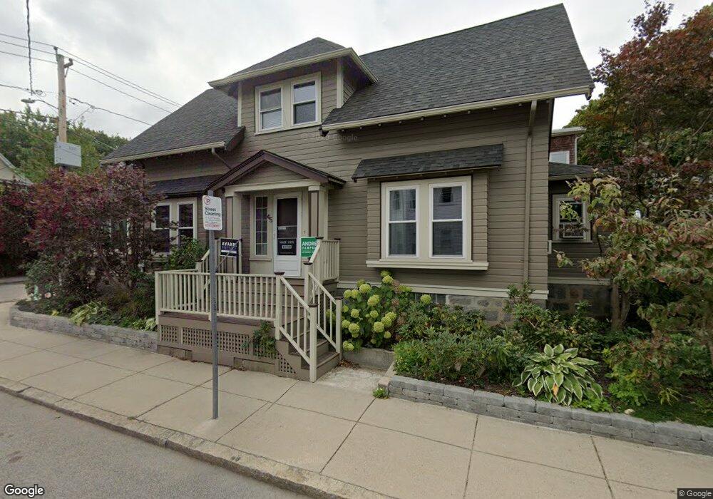
45 Bexley Rd Roslindale, MA 02131
Roslindale NeighborhoodEstimated Value: $733,405 - $838,000
3
Beds
2
Baths
1,550
Sq Ft
$505/Sq Ft
Est. Value
About This Home
This home is located at 45 Bexley Rd, Roslindale, MA 02131 and is currently estimated at $782,351, approximately $504 per square foot. 45 Bexley Rd is a home located in Suffolk County with nearby schools including Brooke Charter School Roslindale, Sacred Heart STEM School, and The Croft School - Jamaica Plain.
Ownership History
Date
Name
Owned For
Owner Type
Purchase Details
Closed on
Jul 17, 2024
Sold by
Ratcliffe David and Vansuch Nina
Bought by
David T Ratcliffe T T and David Ratcliffe
Current Estimated Value
Purchase Details
Closed on
Sep 10, 2007
Sold by
Gordon Cara J and Soulia Jason R
Bought by
Ratcliffe David and Vansuch Nina
Home Financials for this Owner
Home Financials are based on the most recent Mortgage that was taken out on this home.
Original Mortgage
$165,000
Interest Rate
6.74%
Mortgage Type
Purchase Money Mortgage
Create a Home Valuation Report for This Property
The Home Valuation Report is an in-depth analysis detailing your home's value as well as a comparison with similar homes in the area
Home Values in the Area
Average Home Value in this Area
Purchase History
| Date | Buyer | Sale Price | Title Company |
|---|---|---|---|
| David T Ratcliffe T T | -- | None Available | |
| David T Ratcliffe T T | -- | None Available | |
| Ratcliffe David | $365,000 | -- | |
| Ratcliffe David | $365,000 | -- |
Source: Public Records
Mortgage History
| Date | Status | Borrower | Loan Amount |
|---|---|---|---|
| Previous Owner | Ratcliffe David | $225,000 | |
| Previous Owner | Ratcliffe David | $165,000 | |
| Previous Owner | Ratcliffe David | $30,000 |
Source: Public Records
Tax History
| Year | Tax Paid | Tax Assessment Tax Assessment Total Assessment is a certain percentage of the fair market value that is determined by local assessors to be the total taxable value of land and additions on the property. | Land | Improvement |
|---|---|---|---|---|
| 2025 | $6,947 | $599,900 | $203,400 | $396,500 |
| 2024 | $6,520 | $598,200 | $207,500 | $390,700 |
| 2023 | $6,002 | $558,800 | $193,800 | $365,000 |
| 2022 | $5,631 | $517,600 | $179,500 | $338,100 |
| 2021 | $5,134 | $481,200 | $172,600 | $308,600 |
| 2020 | $4,879 | $462,000 | $167,000 | $295,000 |
| 2019 | $4,596 | $436,100 | $133,500 | $302,600 |
| 2018 | $4,351 | $415,200 | $133,500 | $281,700 |
| 2017 | $4,149 | $391,800 | $133,500 | $258,300 |
| 2016 | $3,955 | $359,500 | $133,500 | $226,000 |
| 2015 | $4,157 | $343,300 | $129,000 | $214,300 |
| 2014 | $3,922 | $311,800 | $129,000 | $182,800 |
Source: Public Records
Map
Nearby Homes
- 132 Sycamore St
- 61 Fawndale Rd
- 626 South St
- 23 Rowe St Unit 23 Rowe
- 375 Hyde Park Ave Unit 3
- 472 Hyde Park Ave Unit 472
- 19 Delford St
- 167 Poplar St Unit 1
- 68 Rowe St Unit 3
- 68 Rowe St Unit 2
- 11 S Fairview St Unit 2R
- 7 Basto Terrace
- 46 Belgrade Ave Unit 2
- 18 Robert St Unit 4
- 18 Robert St Unit 14
- 543 Hyde Park Ave Unit 1
- 4 Albano St Unit 2
- 16 Hilburn Place
- 40 Catherine St Unit 2
- 14 Whitford St
- 114 Florence St
- 41 Bexley Rd
- 122 Florence St
- 122 Florence St Unit 2
- 0 Florence St L:
- 39 Bexley Rd
- 108 Florence St
- 42 Bexley Rd
- 124 Florence St Unit 124
- 124 Florence St Unit 126
- 124 Florence St
- 124A Florence St Unit 124A
- 64 Murray Hill Rd
- 37 Bexley Rd
- 37 Bexley Rd Unit 2
- 37 Bexley Rd
- 37 Bexley Rd Unit 1
- 37 Bexley Rd Unit 3
- 37 Bexley Rd Unit 3
- 40 Bexley Rd
Your Personal Tour Guide
Ask me questions while you tour the home.