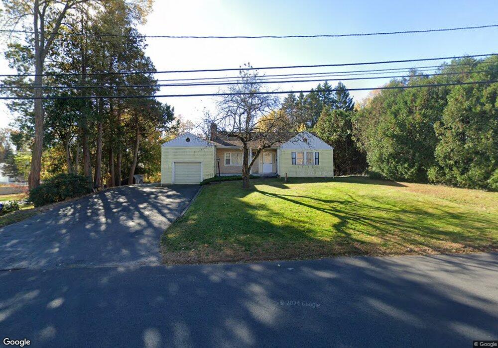
45 Blake Rd New Britain, CT 06053
Estimated Value: $315,166 - $352,000
3
Beds
2
Baths
1,429
Sq Ft
$233/Sq Ft
Est. Value
About This Home
This home is located at 45 Blake Rd, New Britain, CT 06053 and is currently estimated at $332,542, approximately $232 per square foot. 45 Blake Rd is a home located in Hartford County with nearby schools including Holmes School, Pulaski Middle School, and Mountain Laurel Sudbury School.
Ownership History
Date
Name
Owned For
Owner Type
Purchase Details
Closed on
Jun 3, 2002
Sold by
Est Bianco Helen and Bianco Barry L
Bought by
Bianco Lorrie
Current Estimated Value
Home Financials for this Owner
Home Financials are based on the most recent Mortgage that was taken out on this home.
Original Mortgage
$104,000
Interest Rate
7%
Create a Home Valuation Report for This Property
The Home Valuation Report is an in-depth analysis detailing your home's value as well as a comparison with similar homes in the area
Home Values in the Area
Average Home Value in this Area
Purchase History
| Date | Buyer | Sale Price | Title Company |
|---|---|---|---|
| Bianco Lorrie | $130,000 | -- |
Source: Public Records
Mortgage History
| Date | Status | Borrower | Loan Amount |
|---|---|---|---|
| Open | Bianco Lorrie | $99,000 | |
| Closed | Bianco Lorrie | $104,000 |
Source: Public Records
Tax History
| Year | Tax Paid | Tax Assessment Tax Assessment Total Assessment is a certain percentage of the fair market value that is determined by local assessors to be the total taxable value of land and additions on the property. | Land | Improvement |
|---|---|---|---|---|
| 2025 | $6,533 | $166,740 | $62,790 | $103,950 |
| 2024 | $6,601 | $166,740 | $62,790 | $103,950 |
| 2023 | $6,383 | $166,740 | $62,790 | $103,950 |
| 2022 | $5,558 | $112,280 | $28,910 | $83,370 |
| 2021 | $5,558 | $112,280 | $28,910 | $83,370 |
| 2020 | $5,670 | $112,280 | $28,910 | $83,370 |
| 2019 | $5,670 | $112,280 | $28,910 | $83,370 |
| 2018 | $5,670 | $112,280 | $28,910 | $83,370 |
| 2017 | $5,677 | $112,420 | $26,390 | $86,030 |
| 2016 | $5,677 | $112,420 | $26,390 | $86,030 |
| 2015 | $5,509 | $112,420 | $26,390 | $86,030 |
| 2014 | $5,509 | $112,420 | $26,390 | $86,030 |
Source: Public Records
Map
Nearby Homes
- 678 Farmington Ave
- 2415 Corbin Ave
- 40 Hutchinson St
- 21 Skipper St
- 234 Pierremount Ave
- 482 Commonwealth Ave
- 14 Acton St
- 23 Lewis Rd
- 154 Allen St
- 55 Allen St
- 4 Brown St
- 182 Francis St
- 53 Park Dr
- 900 Slater Rd
- 45 Atlantic St Unit C
- 57 Merigold Dr
- 1634 Stanley St
- 50 Curtin Ave
- 545 Burritt St
- 39 Pendleton Rd
- 37 Blake Rd
- 63 Blake Rd
- 29 Blake Rd
- 75 Blake Rd
- 75 Blake Rd Unit 2nd floor apt.
- 46 Blake Rd
- 56 Blake Rd
- 23 Blake Rd
- 38 Blake Rd
- 22 Sandy Brook Dr
- 62 Blake Rd
- 32 Blake Rd
- 28 Sandy Brook Dr
- 525 Farmington Ave
- 72 Blake Rd
- 26 Blake Rd
- 521 Farmington Ave
- 34 Sandy Brook Dr
- 499 Farmington Ave
- 9 Sandy Brook Dr
Your Personal Tour Guide
Ask me questions while you tour the home.