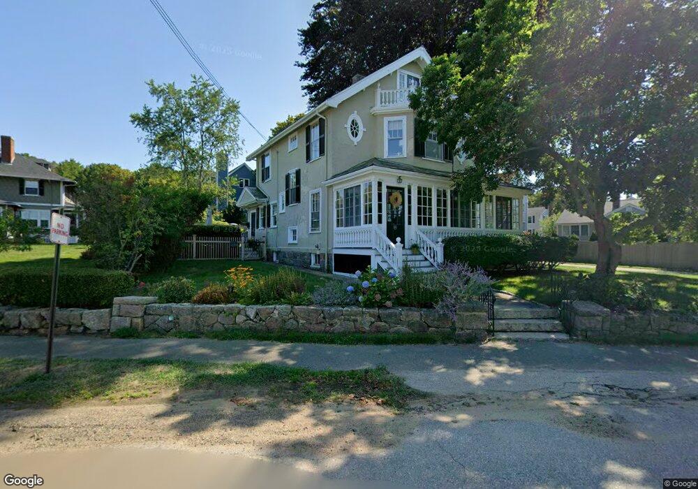
45 Brook St Manchester, MA 01944
Estimated Value: $1,504,704 - $1,733,000
4
Beds
4
Baths
2,267
Sq Ft
$700/Sq Ft
Est. Value
About This Home
This home is located at 45 Brook St, Manchester, MA 01944 and is currently estimated at $1,587,426, approximately $700 per square foot. 45 Brook St is a home located in Essex County with nearby schools including Manchester Essex Regional High School, Tara Montessori School, and Glen Urquhart School.
Ownership History
Date
Name
Owned For
Owner Type
Purchase Details
Closed on
Aug 31, 1999
Sold by
Taylor Georgeanne L
Bought by
Milne Scott and Christie Elizabeth A
Current Estimated Value
Purchase Details
Closed on
Sep 15, 1987
Sold by
Hoban Alan P
Bought by
Gallien John P
Create a Home Valuation Report for This Property
The Home Valuation Report is an in-depth analysis detailing your home's value as well as a comparison with similar homes in the area
Home Values in the Area
Average Home Value in this Area
Purchase History
| Date | Buyer | Sale Price | Title Company |
|---|---|---|---|
| Milne Scott | $450,000 | -- | |
| Gallien John P | $204,000 | -- |
Source: Public Records
Mortgage History
| Date | Status | Borrower | Loan Amount |
|---|---|---|---|
| Closed | Gallien John P | $139,000 | |
| Closed | Gallien John P | $161,000 |
Source: Public Records
Tax History Compared to Growth
Tax History
| Year | Tax Paid | Tax Assessment Tax Assessment Total Assessment is a certain percentage of the fair market value that is determined by local assessors to be the total taxable value of land and additions on the property. | Land | Improvement |
|---|---|---|---|---|
| 2025 | $13,268 | $1,450,100 | $465,100 | $985,000 |
| 2024 | $12,389 | $1,325,000 | $448,500 | $876,500 |
| 2023 | $12,070 | $1,157,200 | $398,600 | $758,600 |
| 2022 | $11,500 | $1,084,900 | $365,400 | $719,500 |
| 2021 | $11,525 | $1,048,700 | $348,800 | $699,900 |
| 2020 | $11,897 | $1,016,800 | $332,200 | $684,600 |
| 2019 | $11,174 | $995,000 | $332,200 | $662,800 |
| 2018 | $10,975 | $995,000 | $332,200 | $662,800 |
| 2017 | $10,945 | $995,000 | $332,200 | $662,800 |
| 2016 | $10,377 | $937,400 | $332,200 | $605,200 |
| 2015 | $9,802 | $904,200 | $299,000 | $605,200 |
Source: Public Records
Map
Nearby Homes
- 56 Summer St Unit A
- 27 Norwood Ave Unit C
- 12 Vine St
- 6 Summer St Unit D
- 48 Union St Unit 1
- 2 Mark St
- 9 Masconomo St
- 2 Sky Top Dr
- 30 Pine St
- 4 Windemere Park Extension
- 4 Knight Rd
- 4 Cobb Ave
- 17 Old Essex Rd
- 1 Woodholm Cir
- 35 Forster Rd
- 239 Summer St
- 37 Forster Rd
- 1 Crooked Ln
- 4 Plum Hill Rd
- 214 Summer St
- 13 Allen Ave
- 11 Allen Ave Unit 3
- 11 Allen Ave Unit 2
- 11 Allen Ave Unit 1
- 49 Brook St
- 53 Brook St Unit 1
- 51 Brook St Unit 1
- 53 Brook St
- 51 Brook St
- 53 Brook St Unit 53
- 51 Brook St Unit 51
- 43 Brook St
- 42 Brook St
- 9 Allen Ave
- 7 Allen Ave
- 10 Allen Ave
- 55 Brook St
- 46 Brook St Unit B
- 46 Brook St Unit A
- 46 Brook St Unit 46B