


45 Bull Rock Ct Livermore, CO 80536
Estimated payment $582/month
Highlights
- City View
- Mountainous Lot
- Community Playground
- Near a National Forest
- Hiking Trails
- Park
About This Lot
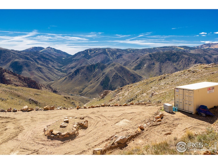
Adjoins National Forest! Absolutely stunning views across meadows, down into Poudre Canyon with glimpses of the Poudre river, south into RMNP, east into Fort Collins, and west towards Cameron Peak. This multi-tiered lot has fantastic potential as a year-round or seasonal homesite, or enjoy camping during the summer. Are you into hunting? This location is ideal with direct access into the national forest. A roughly 70x45 building pad has been graded, with an additional smaller footprint on the upper portion of the lot. Two driveways currently provide access to the lot. A small shed with a loft is on the upper tier, great for storage or camping setup. No utilities currently connected, though the association has a legal shared well agreement for lots on this road and your tap is at the road. Power is nearby. Will need a septic or vault installed. Community has free water available for owners to pickup if you wish to setup a cistern, or they will haul water to you for a small fee. Note this lot is in the 2012 High Park fire burn area, so no trees in the immediate area. But that just makes your views unobstructed. Come see, bring a chair and soak in these amazing views as you decide how you will make this lot your own!
Property Details
Property Type
- Land
Est. Annual Taxes
- $1,177
Lot Details
- 0.99 Acre Lot
- Dirt Road
- Unincorporated Location
- Rock Outcropping
- Steep Slope
- Mountainous Lot
- Property is zoned E11
HOA Fees
- $53 Monthly HOA Fees
Property Views
- City
- Mountain
Farming
- Agricultural
Listing and Financial Details
- Assessor Parcel Number R1086014
Community Details
Overview
- Association fees include common amenities, snow removal, management
- Glacier View Meadows Association
- Glacier View Meadows Subdivision
- Near a National Forest
Recreation
- Community Playground
- Park
- Hiking Trails
Map
Home Values in the Area
Average Home Value in this Area
Tax History
| Year | Tax Paid | Tax Assessment Tax Assessment Total Assessment is a certain percentage of the fair market value that is determined by local assessors to be the total taxable value of land and additions on the property. | Land | Improvement |
|---|---|---|---|---|
| 2025 | $1,235 | $12,555 | $12,555 | -- |
| 2024 | $1,177 | $12,555 | $12,555 | -- |
| 2022 | $674 | $6,960 | $6,960 | $0 |
| 2021 | $663 | $6,960 | $6,960 | $0 |
| 2020 | $501 | $5,220 | $5,220 | $0 |
| 2019 | $503 | $5,220 | $5,220 | $0 |
| 2018 | $364 | $4,060 | $4,060 | $0 |
| 2017 | $363 | $4,060 | $4,060 | $0 |
| 2016 | $286 | $3,190 | $3,190 | $0 |
| 2015 | $284 | $3,190 | $3,190 | $0 |
| 2014 | -- | $1,450 | $1,450 | $0 |
Property History
| Date | Event | Price | Change | Sq Ft Price |
|---|---|---|---|---|
| 06/23/2025 06/23/25 | Price Changed | $81,000 | -4.7% | -- |
| 03/03/2025 03/03/25 | Price Changed | $85,000 | -5.6% | -- |
| 09/26/2024 09/26/24 | For Sale | $90,000 | +50.3% | -- |
| 03/20/2023 03/20/23 | Sold | $59,900 | 0.0% | -- |
| 03/02/2023 03/02/23 | For Sale | $59,900 | 0.0% | -- |
| 01/31/2023 01/31/23 | Off Market | $59,900 | -- | -- |
| 11/10/2022 11/10/22 | For Sale | $59,900 | +254.4% | -- |
| 01/28/2019 01/28/19 | Off Market | $16,900 | -- | -- |
| 08/23/2016 08/23/16 | Sold | $16,900 | -38.5% | -- |
| 07/24/2016 07/24/16 | Pending | -- | -- | -- |
| 01/14/2016 01/14/16 | For Sale | $27,500 | -- | -- |
Purchase History
| Date | Type | Sale Price | Title Company |
|---|---|---|---|
| Warranty Deed | $59,900 | -- | |
| Warranty Deed | $16,900 | Heritage Title | |
| Warranty Deed | $10,000 | Heritage Title | |
| Warranty Deed | $16,000 | -- | |
| Quit Claim Deed | -- | -- | |
| Quit Claim Deed | -- | -- |
Mortgage History
| Date | Status | Loan Amount | Loan Type |
|---|---|---|---|
| Open | $41,930 | Seller Take Back |
Source: IRES MLS
MLS Number: 1019406
APN: 29364-05-233
Disclaimer: Certain information contained herein is derived from information provided by parties other than Homes.com. All information provided is deemed reliable, but is not guaranteed to be accurate and should be independently verified.
![]() Information source: Information and Real Estate Services, LLC. Provided for limited non-commercial use only under IRES Rules © Copyright IRES.
Information source: Information and Real Estate Services, LLC. Provided for limited non-commercial use only under IRES Rules © Copyright IRES.
Listing information is provided exclusively for consumers' personal, non-commercial use and may not be used for any purpose other than to identify prospective properties consumers may be interested in purchasing.
Information deemed reliable but not guaranteed by the MLS.
- 151 Black Mountain Ct
- 37 Black Mountain Ct
- 598 Mount McConnell Dr
- 107 Mount Audubon Way
- 743 Horse Mountain Dr
- 572 Horse Mountain Dr
- 112 Rabbit Ears Ct
- 42 Smokey Mountain Ct
- 232 Red Mountain Ct
- 1425 Horse Mountain Dr
- 84 Carson Peak Ct
- 38 Carson Peak Ct
- 890 Meadow Mountain Dr
- 1324 Meadow Mountain Dr
- 1222 Meadow Mountain Dr
- 1360 Meadow Mountain Dr
- 132 Singing Pines Ct
- 443 Meadow Mountain Dr
- 104 Sheep Mountain Ct
- 634 Meadow Mountain Dr
- 9996 Poudre Canyon Rd
- 2811 Tharp Dr
- 850 S Overland Trail
- 3002 W Elizabeth St Unit 16F
- 421 N Impala Dr
- 3002 W Elizabeth St Unit 2-F
- 1625 Banyan Dr Unit 1625
- 1618 Banyan Dr Unit 4
- 155 Briarwood Rd
- 5525 W County Rd 38 E
- 1736 Palm Dr Unit 3
- 1942 Pecan St Unit 2
- 1942 Pecan St Unit 4
- 523 N Bryan Ave Unit 2
- 1931 Ross Ct
- 2955 W Stuart St Unit 8
- 2929 Ross Dr S74
- 2155 Orchard Place
- 1040 Ponderosa Dr
- 2008 W Plum St Unit 2A
