


OPEN SUN 11AM - 1PM
$101K PRICE DROP
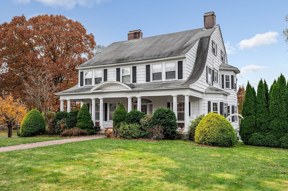
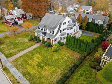
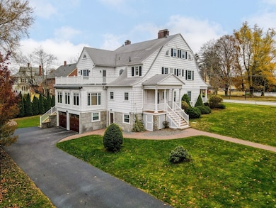
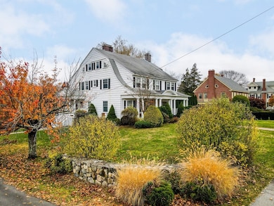
45 Clark Rd Lowell, MA 01852
Belvidere NeighborhoodEstimated payment $6,086/month
Total Views
204,186
4
Beds
5
Baths
5,889
Sq Ft
$170
Price per Sq Ft
Highlights
- Golf Course Community
- Media Room
- Colonial Architecture
- Medical Services
- Custom Closet System
- Fireplace in Primary Bedroom
About This Home
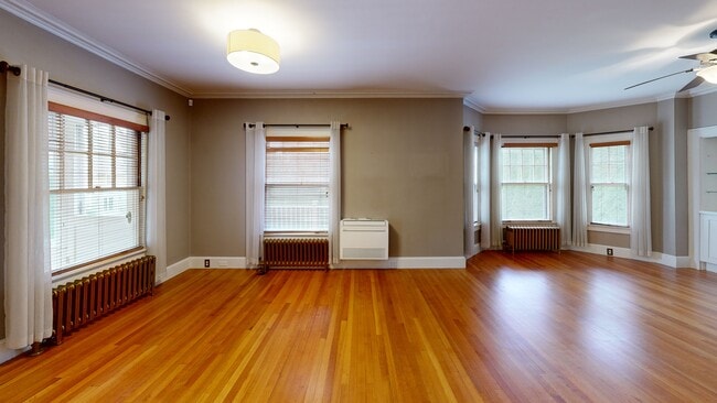
Welcome to 45 Clark Road, a distinguished Belvidere corner lot gem blending historic charm with modern comfort. This exceptional residence showcases classic shingle siding, a gambrel roof, and a full width front porch anchored by impressive Doric columns. The elegant center entrance opens to a grand foyer with a beautifully turned staircase and exquisite millwork that continues throughout the home. Offering 4 bedrooms, 3 full and 2 half baths, this home includes 4 fireplaces, a 3rd floor media room, and a finished basement featuring a game room and bar, perfect for entertaining. The primary suite has been tastefully updated with an en suite bath complete with a soaking tub, separate shower, and an adjoining laundry room. Additional highlights include a 2 car garage, a new steam gas heating system, and 13 Mitsubishi mini split units. Lovingly maintained & thoughtfully enhanced, this unique residence seamlessly combines timeless architectural character with modern functionality.
Open House Schedule
-
Sunday, March 08, 202611:00 am to 1:00 pm3/8/2026 11:00:00 AM +00:003/8/2026 1:00:00 PM +00:00Join us on Sunday March 8th from 11-1pm at our open house.Add to Calendar
Home Details
Home Type
- Single Family
Est. Annual Taxes
- $11,455
Year Built
- Built in 1900
Lot Details
- 0.41 Acre Lot
- Corner Lot
- Property is zoned SSF
Parking
- 2 Car Attached Garage
- Tuck Under Parking
- Heated Garage
- Side Facing Garage
- Garage Door Opener
- Driveway
- 5 Open Parking Spaces
- Off-Street Parking
Home Design
- Colonial Architecture
- Stone Foundation
- Frame Construction
- Foam Insulation
- Shingle Roof
Interior Spaces
- Chair Railings
- Crown Molding
- Beamed Ceilings
- Cathedral Ceiling
- Ceiling Fan
- Decorative Lighting
- Light Fixtures
- Insulated Windows
- French Doors
- Insulated Doors
- Entrance Foyer
- Living Room with Fireplace
- Dining Room with Fireplace
- 4 Fireplaces
- Media Room
- Home Office
- Game Room
- Sun or Florida Room
Kitchen
- Range with Range Hood
- Dishwasher
- Wine Cooler
- Stainless Steel Appliances
- Solid Surface Countertops
- Disposal
Flooring
- Wood
- Ceramic Tile
- Vinyl
Bedrooms and Bathrooms
- 4 Bedrooms
- Fireplace in Primary Bedroom
- Primary bedroom located on second floor
- Custom Closet System
- Cedar Closet
- Dual Closets
- Walk-In Closet
- Double Vanity
- Soaking Tub
- Bathtub with Shower
- Separate Shower
- Linen Closet In Bathroom
Laundry
- Laundry Room
- Laundry on upper level
- Washer Hookup
Finished Basement
- Walk-Out Basement
- Basement Fills Entire Space Under The House
- Interior Basement Entry
- Garage Access
- Sump Pump
Outdoor Features
- Enclosed Patio or Porch
- Rain Gutters
Location
- Property is near public transit and schools
Utilities
- Ductless Heating Or Cooling System
- 13 Cooling Zones
- 1 Heating Zone
- Heating System Uses Natural Gas
- Hot Water Heating System
- Heating System Uses Steam
- 200+ Amp Service
- Tankless Water Heater
- Gas Water Heater
- High Speed Internet
Listing and Financial Details
- Assessor Parcel Number M:248 B:1285 L:45,3197471
Community Details
Overview
- No Home Owners Association
Amenities
- Medical Services
- Shops
- Coin Laundry
Recreation
- Golf Course Community
- Tennis Courts
- Park
- Jogging Path
3D Interior and Exterior Tours
Floorplans
Map
Create a Home Valuation Report for This Property
The Home Valuation Report is an in-depth analysis detailing your home's value as well as a comparison with similar homes in the area
Home Values in the Area
Average Home Value in this Area
Tax History
| Year | Tax Paid | Tax Assessment Tax Assessment Total Assessment is a certain percentage of the fair market value that is determined by local assessors to be the total taxable value of land and additions on the property. | Land | Improvement |
|---|---|---|---|---|
| 2025 | $11,455 | $997,800 | $257,500 | $740,300 |
| 2024 | $11,685 | $981,100 | $240,600 | $740,500 |
| 2023 | $11,096 | $893,400 | $209,200 | $684,200 |
| 2022 | $11,082 | $873,300 | $190,300 | $683,000 |
| 2021 | $10,382 | $771,300 | $165,400 | $605,900 |
| 2020 | $9,961 | $745,600 | $165,400 | $580,200 |
| 2019 | $9,653 | $687,500 | $164,500 | $523,000 |
| 2018 | $9,918 | $689,200 | $156,600 | $532,600 |
| 2017 | $9,306 | $623,700 | $145,300 | $478,400 |
| 2016 | $9,281 | $612,200 | $133,800 | $478,400 |
| 2015 | $8,695 | $561,700 | $133,800 | $427,900 |
| 2013 | $7,747 | $516,100 | $147,800 | $368,300 |
Source: Public Records
Property History
| Date | Event | Price | List to Sale | Price per Sq Ft |
|---|---|---|---|---|
| 02/16/2026 02/16/26 | Price Changed | $999,000 | -9.2% | $170 / Sq Ft |
| 11/17/2025 11/17/25 | For Sale | $1,100,000 | -- | $187 / Sq Ft |
Source: MLS Property Information Network (MLS PIN)
Purchase History
| Date | Type | Sale Price | Title Company |
|---|---|---|---|
| Not Resolvable | $614,900 | -- | |
| Deed | $489,000 | -- | |
| Deed | $489,000 | -- |
Source: Public Records
Mortgage History
| Date | Status | Loan Amount | Loan Type |
|---|---|---|---|
| Previous Owner | $325,000 | Purchase Money Mortgage |
Source: Public Records
About the Listing Agent
CEO Of the Espinola Group Powered By Keller Williams Realty Merrimack Valley
Dynamic and Accomplished Professional Real Estate Agent with over 20 Years of Experience in the Industry. Kelly Espinola maintains a Proven Track Record of Closing Business, Working Effectively with all Transaction Stakeholders, and Developing and Upholding Long-Term Relationships. Specialize in both Residential and Commercial Real Estate transactions where she is able to Generate Business through aggressive
Kelly's Other Listings
Source: MLS Property Information Network (MLS PIN)
MLS Number: 73455489
APN: LOWE-000248-001285-000045
Disclaimer: Certain information contained herein is derived from information provided by parties other than Homes.com. All information provided is deemed reliable, but is not guaranteed to be accurate and should be independently verified.
![]() The property listing data and information, or the Images, set forth herein were provided to MLS Property Information Network, Inc. from third party sources, including sellers, lessors and public records, and were compiled by MLS Property Information Network, Inc. The property listing data and information, and the Images, are for the personal, non-commercial use of consumers having a good faith interest in purchasing or leasing listed properties of the type displayed to them and may not be used for any purpose other than to identify prospective properties which such consumers may have a good faith interest in purchasing or leasing. MLS Property Information Network, Inc. and its subscribers disclaim any and all representations and warranties as to the accuracy of the property listing data and information, or as to the accuracy of any of the Images, set forth herein.
The property listing data and information, or the Images, set forth herein were provided to MLS Property Information Network, Inc. from third party sources, including sellers, lessors and public records, and were compiled by MLS Property Information Network, Inc. The property listing data and information, and the Images, are for the personal, non-commercial use of consumers having a good faith interest in purchasing or leasing listed properties of the type displayed to them and may not be used for any purpose other than to identify prospective properties which such consumers may have a good faith interest in purchasing or leasing. MLS Property Information Network, Inc. and its subscribers disclaim any and all representations and warranties as to the accuracy of the property listing data and information, or as to the accuracy of any of the Images, set forth herein.
Nearby Homes
- 251 Clark Rd
- 42 Pentucket Ave
- 206 Burnham Rd
- 67 Wedgemere Dr
- 100 Merrimack Ave Unit 25
- 100 Merrimack Ave Unit 9
- 194 River Rd
- 164 Bradley St
- 42 Christian St
- 52 Christian St
- Lots 1-12 Christian Hill Dev
- 81 Reservoir St
- 234 Nesmith St Unit 8
- 313 Nesmith St
- 44 Hanks St
- 3 Vernon St
- 11 Joseph Ave
- Lot 11 Christian St
- Lot 12 Christian St
- Lot 9 Christian St
- 11 Beacon St Unit Quiet Community
- 270 Nesmith St Unit 1
- 250 Nesmith St Unit 10
- 253 Stackpole St Unit 255 Stackpole St
- 48 Boylston St Unit 1
- 58 Willow St
- 85 Sherman St Unit 1
- 85 Sherman St Unit 3
- 52 Willow St Unit 52
- 150 Pleasant St Unit 3
- 505 High St Unit 505
- 249 E Merrimack St Unit 2nd Fl
- 39 Myrtle St
- 89 3rd St Unit 1
- 168 Warren Ct Unit 1
- 16 2nd St Unit 3
- 594 Merrimack Ave
- 151r Methuen St Unit 151R
- 150 Massmills Dr
- 23 W 5th St Unit 1B
Your Personal Tour Guide
Ask me questions while you tour the home.