
A
Seller's Agent in 2025
April Henrikson
Realty Choice, Inc.
(781) 910-4942
1 in this area
42 Total Sales
Estimated Value: $1,509,097 - $1,613,000
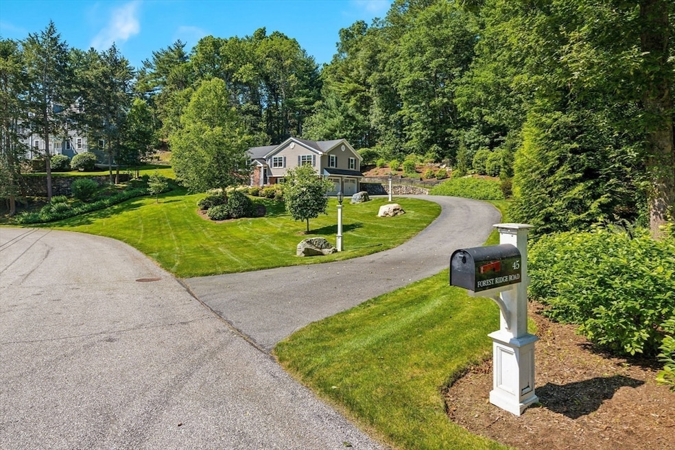
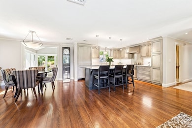
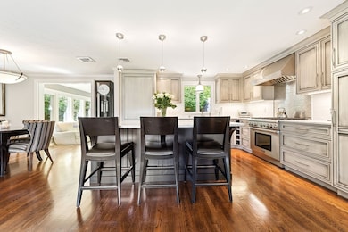
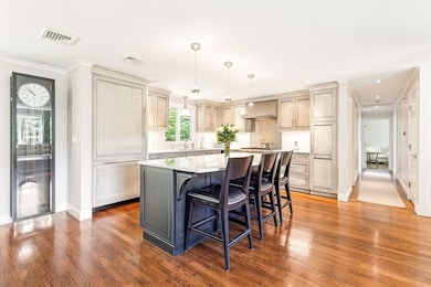
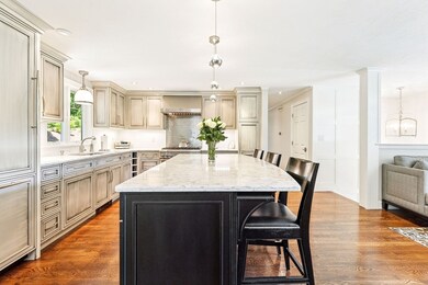
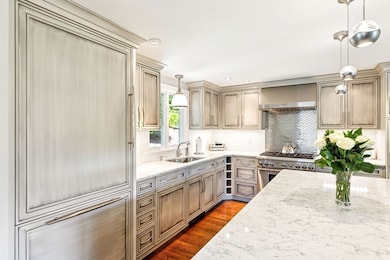
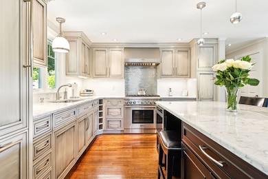
Meticulously maintained home nestled in a lovely neighborhood cul-de-sac setting. Gut-renovated in 2014, this property boasts custom designer elements with attention to detail. The kitchen finished with paneled Thermador appliances and quartz center island flows seamlessly into dining room with open concept floor-plan. Living room is anchored by a striking gas fireplace with custom built-ins. French pocket doors open to sunroom with radiant heat and ductless split a/c overlooking nearly an acre of professionally manicured grounds. Primary en-suite bedroom, two additional bedrooms and full bath complete the first floor. Lower level includes bedroom/office with 2nd gas fireplace, half bath w/laundry, bonus room, and 2-car garage. Direct-wired security system. Less than a 1/2 mile to Kendal Green commuter rail station and minutes to I-95/90, this turnkey residence offers the perfect blend of comfort and convenience at a rare price point in a town with top-rated schools. Welcome to Weston!
| Date | Buyer | Sale Price | Title Company |
|---|---|---|---|
| Cong Rong | $1,605,000 | -- | |
| Prifti Robert W | -- | -- | |
| Prifti Robert W | -- | -- | |
| Prifti Robert W | -- | -- | |
| Mcrae Susan H | $426,000 | -- | |
| Mcrae Susan H | $426,000 | -- | |
| Prifti Robert W | -- | -- |
| Date | Status | Borrower | Loan Amount |
|---|---|---|---|
| Previous Owner | Prifti Robert W | $30,000 | |
| Previous Owner | Prifti Robert W | $15,000 |
| Date | Event | Price | List to Sale | Price per Sq Ft |
|---|---|---|---|---|
| 11/14/2025 11/14/25 | Sold | $1,605,000 | +3.5% | $698 / Sq Ft |
| 09/22/2025 09/22/25 | Pending | -- | -- | -- |
| 09/16/2025 09/16/25 | For Sale | $1,550,000 | -- | $674 / Sq Ft |
| Year | Tax Paid | Tax Assessment Tax Assessment Total Assessment is a certain percentage of the fair market value that is determined by local assessors to be the total taxable value of land and additions on the property. | Land | Improvement |
|---|---|---|---|---|
| 2025 | $12,187 | $1,097,900 | $689,700 | $408,200 |
| 2024 | $11,776 | $1,059,000 | $689,700 | $369,300 |
| 2023 | $11,557 | $976,100 | $689,700 | $286,400 |
| 2022 | $11,150 | $870,400 | $647,300 | $223,100 |
| 2021 | $10,779 | $830,400 | $617,700 | $212,700 |
| 2020 | $10,437 | $813,500 | $617,700 | $195,800 |
| 2019 | $9,508 | $755,200 | $578,700 | $176,500 |
| 2018 | $9,486 | $758,300 | $578,700 | $179,600 |
| 2017 | $9,403 | $758,300 | $578,700 | $179,600 |
| 2016 | $9,261 | $761,600 | $578,700 | $182,900 |
| 2015 | $8,910 | $725,600 | $551,700 | $173,900 |
A
Seller's Agent in 2025
April Henrikson
Realty Choice, Inc.
(781) 910-4942
1 in this area
42 Total Sales
L
Buyer's Agent in 2025
Liyuan Bai
Gibson Sotheby's International Realty
11 in this area
46 Total Sales
Source: MLS Property Information Network (MLS PIN)
MLS Number: 73431404
APN: WEST-000019-000048
Disclaimer: Certain information contained herein is derived from information provided by parties other than Homes.com. All information provided is deemed reliable, but is not guaranteed to be accurate and should be independently verified.
![]() The property listing data and information, or the Images, set forth herein were provided to MLS Property Information Network, Inc. from third party sources, including sellers, lessors and public records, and were compiled by MLS Property Information Network, Inc. The property listing data and information, and the Images, are for the personal, non-commercial use of consumers having a good faith interest in purchasing or leasing listed properties of the type displayed to them and may not be used for any purpose other than to identify prospective properties which such consumers may have a good faith interest in purchasing or leasing. MLS Property Information Network, Inc. and its subscribers disclaim any and all representations and warranties as to the accuracy of the property listing data and information, or as to the accuracy of any of the Images, set forth herein.
The property listing data and information, or the Images, set forth herein were provided to MLS Property Information Network, Inc. from third party sources, including sellers, lessors and public records, and were compiled by MLS Property Information Network, Inc. The property listing data and information, and the Images, are for the personal, non-commercial use of consumers having a good faith interest in purchasing or leasing listed properties of the type displayed to them and may not be used for any purpose other than to identify prospective properties which such consumers may have a good faith interest in purchasing or leasing. MLS Property Information Network, Inc. and its subscribers disclaim any and all representations and warranties as to the accuracy of the property listing data and information, or as to the accuracy of any of the Images, set forth herein.
Ask me questions while you tour the home.