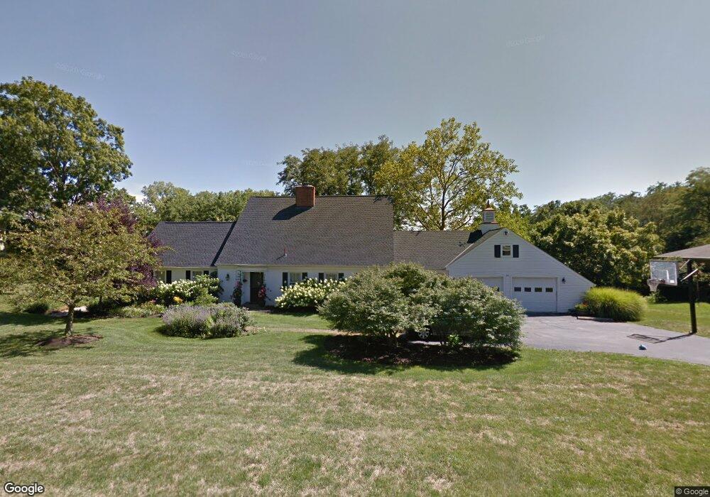
45 Hillside Dr Delaware, OH 43015
Estimated Value: $473,000 - $608,000
4
Beds
3
Baths
2,969
Sq Ft
$186/Sq Ft
Est. Value
About This Home
This home is located at 45 Hillside Dr, Delaware, OH 43015 and is currently estimated at $551,106, approximately $185 per square foot. 45 Hillside Dr is a home located in Delaware County with nearby schools including Ervin Carlisle Elementary School, John C. Dempsey Middle School, and Rutherford B. Hayes High School.
Ownership History
Date
Name
Owned For
Owner Type
Purchase Details
Closed on
Aug 14, 2019
Sold by
Belch Patricia A and Belch Richard P
Bought by
Belch Patricia A and Belch Richard P
Current Estimated Value
Purchase Details
Closed on
Jan 14, 2010
Sold by
Belch Patricia A
Bought by
Belch Richard P and Belch Patricia A
Home Financials for this Owner
Home Financials are based on the most recent Mortgage that was taken out on this home.
Original Mortgage
$197,000
Interest Rate
4.15%
Mortgage Type
New Conventional
Purchase Details
Closed on
Jan 7, 1997
Sold by
Ubben Richard T
Bought by
Belch Patricia A
Home Financials for this Owner
Home Financials are based on the most recent Mortgage that was taken out on this home.
Original Mortgage
$180,000
Interest Rate
7.6%
Mortgage Type
New Conventional
Create a Home Valuation Report for This Property
The Home Valuation Report is an in-depth analysis detailing your home's value as well as a comparison with similar homes in the area
Home Values in the Area
Average Home Value in this Area
Purchase History
| Date | Buyer | Sale Price | Title Company |
|---|---|---|---|
| Belch Patricia A | -- | None Available | |
| Belch Richard P | -- | Elite Land Title | |
| Belch Patricia A | $225,000 | -- |
Source: Public Records
Mortgage History
| Date | Status | Borrower | Loan Amount |
|---|---|---|---|
| Closed | Belch Richard P | $197,000 | |
| Closed | Belch Patricia A | $180,000 |
Source: Public Records
Tax History Compared to Growth
Tax History
| Year | Tax Paid | Tax Assessment Tax Assessment Total Assessment is a certain percentage of the fair market value that is determined by local assessors to be the total taxable value of land and additions on the property. | Land | Improvement |
|---|---|---|---|---|
| 2024 | $7,828 | $165,660 | $36,930 | $128,730 |
| 2023 | $7,843 | $165,660 | $36,930 | $128,730 |
| 2022 | $6,582 | $120,620 | $22,790 | $97,830 |
| 2021 | $6,728 | $120,620 | $22,790 | $97,830 |
| 2020 | $6,805 | $120,620 | $22,790 | $97,830 |
| 2019 | $6,493 | $104,310 | $22,790 | $81,520 |
| 2018 | $6,583 | $104,310 | $22,790 | $81,520 |
| 2017 | $5,960 | $93,210 | $16,280 | $76,930 |
| 2016 | $5,369 | $93,210 | $16,280 | $76,930 |
| 2015 | $5,399 | $93,210 | $16,280 | $76,930 |
| 2014 | $5,485 | $93,210 | $16,280 | $76,930 |
| 2013 | $5,516 | $93,210 | $16,280 | $76,930 |
Source: Public Records
Map
Nearby Homes
- 439 Durham Ln
- 217 Brushmore Ct
- 154 Lexington Blvd
- 351 W William St
- 830 Buehler Dr
- 115 Keystoner Way
- 87 Campbell St
- 1523 Plowington Dr
- 142 Kettering Bend
- 297 W William St
- 123 Helen Ct
- 592 Willis Ln
- 590 Willis Ln
- 586 Willis Ln
- 370 Little Creek Dr Unit 370
- 131 Flowering Meadow Dr
- 407 Garnet Ranch Dr
- 388 Garnet Ranch Dr
- 394 Garnet Ranch Dr
- 400 Garnet Ranch Dr