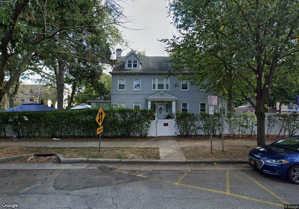
45 Hilton Ave Hempstead, NY 11550
Estimated Value: $855,663
--
Bed
3
Baths
2,698
Sq Ft
$317/Sq Ft
Est. Value
About This Home
This home is located at 45 Hilton Ave, Hempstead, NY 11550 and is currently estimated at $855,663, approximately $317 per square foot. 45 Hilton Ave is a home located in Nassau County with nearby schools including The Academy Charter School, Crescent School, and St Joseph Elementary School.
Ownership History
Date
Name
Owned For
Owner Type
Purchase Details
Closed on
Oct 27, 2008
Sold by
Powell Milton
Bought by
Dewar Kimesha and Bassett Amin
Current Estimated Value
Purchase Details
Closed on
Mar 11, 2005
Sold by
Bedesi Nan
Bought by
Powell Milton
Purchase Details
Closed on
Oct 21, 2002
Sold by
Bank Of New York
Bought by
Bedesi Nan
Purchase Details
Closed on
Jul 15, 2002
Sold by
Schultz Claudia S
Purchase Details
Closed on
Aug 18, 1999
Sold by
Solomon Keith B
Bought by
Triple A Property People Corp
Purchase Details
Closed on
Feb 20, 1998
Sold by
Montiel Rogello
Bought by
Solomon Keith B and Wills Allan
Create a Home Valuation Report for This Property
The Home Valuation Report is an in-depth analysis detailing your home's value as well as a comparison with similar homes in the area
Home Values in the Area
Average Home Value in this Area
Purchase History
| Date | Buyer | Sale Price | Title Company |
|---|---|---|---|
| Dewar Kimesha | $450,000 | The Judicial Title Insurance | |
| Dewar Kimesha | $450,000 | The Judicial Title Insurance | |
| Dewar Kimesha | $450,000 | The Judicial Title Insurance | |
| Powell Milton | $580,000 | -- | |
| Powell Milton | $580,000 | -- | |
| Bedesi Nan | $291,500 | -- | |
| Bedesi Nan | $291,500 | -- | |
| -- | $293,319 | -- | |
| -- | $293,319 | -- | |
| Triple A Property People Corp | -- | Old Republic Natl Title Ins | |
| Triple A Property People Corp | -- | Old Republic Natl Title Ins | |
| Triple A Property People Corp | -- | Old Republic Natl Title Ins | |
| Solomon Keith B | $280,000 | -- | |
| Solomon Keith B | $280,000 | -- |
Source: Public Records
Tax History Compared to Growth
Tax History
| Year | Tax Paid | Tax Assessment Tax Assessment Total Assessment is a certain percentage of the fair market value that is determined by local assessors to be the total taxable value of land and additions on the property. | Land | Improvement |
|---|---|---|---|---|
| 2025 | $18,298 | $721 | $259 | $462 |
| 2024 | $1,892 | $721 | $259 | $462 |
| 2023 | $18,163 | $721 | $259 | $462 |
| 2022 | $18,163 | $721 | $259 | $462 |
| 2021 | $26,813 | $699 | $251 | $448 |
| 2020 | $18,986 | $1,094 | $583 | $511 |
| 2019 | $18,455 | $1,094 | $583 | $511 |
| 2018 | $17,739 | $1,094 | $0 | $0 |
| 2017 | $14,293 | $1,094 | $583 | $511 |
| 2016 | $16,207 | $1,094 | $583 | $511 |
| 2015 | $1,832 | $1,094 | $583 | $511 |
| 2014 | $1,832 | $1,094 | $583 | $511 |
| 2013 | $1,696 | $1,094 | $583 | $511 |
Source: Public Records
Map
Nearby Homes
- 35 Mulford Place
- 22 Mulford Place Unit 2D
- 22 Mulford Place Unit 6C
- 32 Cathedral Ave Unit 6c
- 82 Hilton Ave
- 30 Cathedral Ave Unit 4A
- 144 Hilton Ave
- 144 N Franklin St
- 39 Hilbert St
- 44 Saint Pauls Rd S
- 14 Parsons Dr
- 20 Wendell St Unit A16
- 20 Wendell St Unit E2
- 20 Wendell St Unit 39C
- 24 Parsons Dr
- 60 Parsons Dr
- 200 Hilton Ave Unit 55
- 60 Long Dr
- 47 Stratford Rd
- 87 Parsons Dr
- 41 Hilton Ave
- 32 Mulford Place
- 37 Hilton Ave
- 39 Mulford Place
- 63 Hilton Ave
- 22-24 Mulford Place Unit 5D
- 24 Mulford Place Unit 6F
- 24 Mulford Place Unit 6E
- 24 Mulford Place Unit B
- 24 Mulford Place Unit 1
- 24 Mulford Place Unit 2E
- 24 Mulford Place Unit 5C
- 24 Mulford Place Unit 2B
- 24 Mulford Place Unit 6C
- 24 Mulford Place Unit 1E
- 24 Mulford Place Unit 4F
- 24 Mulford Place Unit 3B
- 24 Mulford Place Unit 6D
- 24 Mulford Place Unit 5D
- 24 Mulford Place Unit 3E