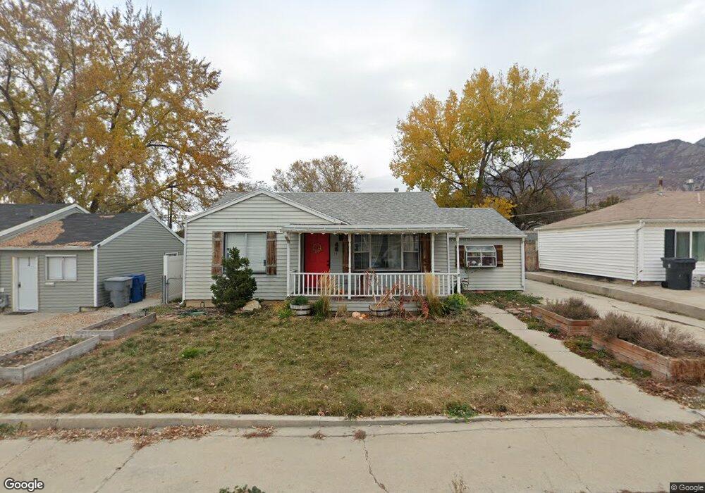
45 Maple Ln Pleasant Grove, UT 84062
Estimated Value: $397,000 - $437,000
3
Beds
1
Bath
1,254
Sq Ft
$333/Sq Ft
Est. Value
About This Home
This home is located at 45 Maple Ln, Pleasant Grove, UT 84062 and is currently estimated at $417,327, approximately $332 per square foot. 45 Maple Ln is a home located in Utah County with nearby schools including Mount Mahogany School, Pleasant Grove Junior High School, and Pleasant Grove High School.
Ownership History
Date
Name
Owned For
Owner Type
Purchase Details
Closed on
Sep 29, 2020
Sold by
Porter Nathan A and Porter Rachel A
Bought by
Riggs Molly and Mccombs Barry Lee
Current Estimated Value
Home Financials for this Owner
Home Financials are based on the most recent Mortgage that was taken out on this home.
Original Mortgage
$240,800
Outstanding Balance
$214,179
Interest Rate
2.9%
Mortgage Type
New Conventional
Estimated Equity
$203,148
Purchase Details
Closed on
Jul 2, 2018
Sold by
Breakwell Liam J and Breakwell Kimberly D
Bought by
Porter Nathan A and Porter Rachel A
Home Financials for this Owner
Home Financials are based on the most recent Mortgage that was taken out on this home.
Original Mortgage
$226,100
Interest Rate
4.6%
Mortgage Type
New Conventional
Purchase Details
Closed on
Jun 30, 2016
Sold by
Fowler Karl E and Fowler Alanna S
Bought by
Breakwell Liam J and Breakwell Kimberly D
Home Financials for this Owner
Home Financials are based on the most recent Mortgage that was taken out on this home.
Original Mortgage
$181,649
Interest Rate
3.62%
Mortgage Type
FHA
Create a Home Valuation Report for This Property
The Home Valuation Report is an in-depth analysis detailing your home's value as well as a comparison with similar homes in the area
Home Values in the Area
Average Home Value in this Area
Purchase History
| Date | Buyer | Sale Price | Title Company |
|---|---|---|---|
| Riggs Molly | -- | First American Amrican Park | |
| Porter Nathan A | -- | Eagle Pointe Title Ins Agenc | |
| Breakwell Liam J | -- | Eagle Pointe Title Insurance |
Source: Public Records
Mortgage History
| Date | Status | Borrower | Loan Amount |
|---|---|---|---|
| Open | Riggs Molly | $240,800 | |
| Previous Owner | Porter Nathan A | $226,100 | |
| Previous Owner | Breakwell Liam J | $181,649 |
Source: Public Records
Tax History Compared to Growth
Tax History
| Year | Tax Paid | Tax Assessment Tax Assessment Total Assessment is a certain percentage of the fair market value that is determined by local assessors to be the total taxable value of land and additions on the property. | Land | Improvement |
|---|---|---|---|---|
| 2025 | $1,510 | $189,365 | $187,000 | $157,300 |
| 2024 | $1,510 | $180,235 | $0 | $0 |
| 2023 | $1,488 | $181,830 | $0 | $0 |
| 2022 | $1,690 | $205,425 | $0 | $0 |
| 2021 | $1,457 | $269,700 | $134,200 | $135,500 |
| 2020 | $1,339 | $243,000 | $119,800 | $123,200 |
| 2019 | $1,167 | $218,900 | $110,100 | $108,800 |
| 2018 | $973 | $172,700 | $100,400 | $72,300 |
| 2017 | $856 | $80,905 | $0 | $0 |
| 2016 | $844 | $76,945 | $0 | $0 |
| 2015 | $891 | $76,945 | $0 | $0 |
| 2014 | $887 | $75,900 | $0 | $0 |
Source: Public Records
Map
Nearby Homes
- 121 E 700 S
- 165 E 500 S
- 380 S 300 E
- 190 E 200 S
- 169 W 200 S
- 435 E 790 S Unit 8
- 264 W State St Unit 18
- 379 S 375 E
- 165 S 200 E
- 540 E 500 S Unit 9
- 534 S Locust Ave
- 530 E 500 S
- 557 N Buffalo Grass Ln
- 556 N Cornstalk Ln
- 1277 W Sweet Corn Ln
- 383 S 790 W
- 278 S 740 W
- 146 N 200 E
- 75 S 500 E
- 1434 W Watson Ln