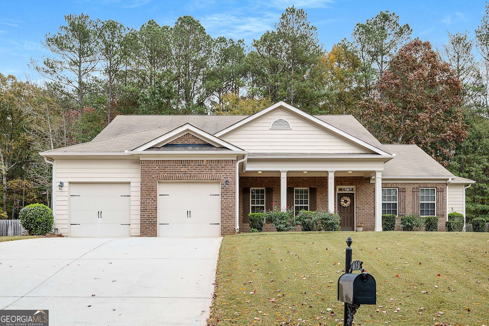
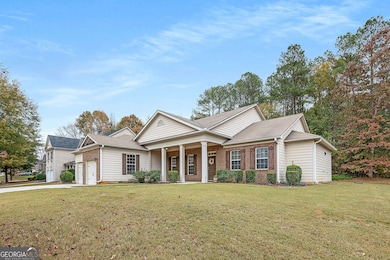
45 Mulberry Dr Senoia, GA 30276
Estimated payment $2,881/month
Highlights
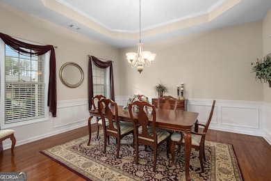
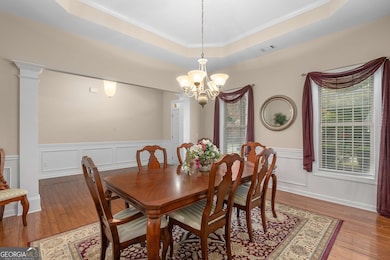
- Dining Room Seats More Than Twelve
- Vaulted Ceiling
- Wood Flooring
- Willis Road Elementary School Rated A-
- Ranch Style House
- Great Room
About This Home
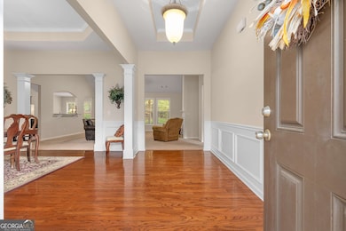
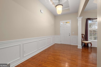
MOVE IN READY RANCH IN HERITAGE POINTE! Beautiful 3 bedroom 2 1/2 bath home in sought after neighborhood with golf cart access to DOWNTOWN SENOIA! The OPEN floor plan features a large dining room with trey ceiling, and huge great room with vaulted ceiling, fireplace and built-in bookcases. With a vaulted ceiling, the large kitchen with views to the great room, has stainless steel appliances, granite tops, a big prep island, all open to the breakfast room which opens to a great covered back porch and private back yard. Spacious Owner's suite, with sitting area and lovely spa style bath with a double vanity, soaking tub, separate shower and walk in closet. Located on the opposite side of the house are 2 roomy guest suites that share a Jack & Jill style bathroom. The house is complete with a full size laundry room, powder room, pantry, and 2 car garage! With a PRIME location close to both PEACHTREE CITY AND DOWNTOWN SENOIA, plus AMAZING resort style neighborhood amenities, including, SWIMMING POOL with cabana seating, TENNIS and BASKETBALL COURTS, PLAYGROUND, and CLUBHOUSE, this is the PERFECT place to call HOME!
Listing Agent
Atlanta Fine Homes - Sotheby's Int'l License #342845 Listed on: 11/11/2025
Home Details
Home Type
- Single Family
Est. Annual Taxes
- $5,127
Year Built
- Built in 2009
Lot Details
- 0.55 Acre Lot
- Level Lot
HOA Fees
- $42 Monthly HOA Fees
Home Design
- Ranch Style House
- Traditional Architecture
- Slab Foundation
- Composition Roof
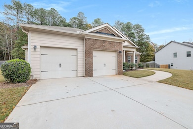
- Concrete Siding
- Brick Front
Interior Spaces
- 2,698 Sq Ft Home
- Bookcases
- Tray Ceiling
- Vaulted Ceiling
- Factory Built Fireplace
- Gas Log Fireplace
- Entrance Foyer
- Family Room with Fireplace
- Great Room
- Dining Room Seats More Than Twelve
- Formal Dining Room
Kitchen
- Breakfast Area or Nook
- Oven or Range
- Microwave
- Dishwasher
- Stainless Steel Appliances
- Kitchen Island
- Solid Surface Countertops
Flooring
- Wood
- Carpet
- Tile
Bedrooms and Bathrooms
- 3 Main Level Bedrooms
- Split Bedroom Floorplan
- Walk-In Closet
- Double Vanity
- Soaking Tub
- Bathtub Includes Tile Surround
- Separate Shower
Laundry
- Laundry Room
- Laundry in Hall
Parking
- 2 Car Garage
- Parking Accessed On Kitchen Level
Outdoor Features
- Veranda
- Porch
Schools
- Willis Road Elementary School
- East Coweta Middle School
- East Coweta High School
Utilities
- Central Heating and Cooling System
- Underground Utilities
- Phone Available
- Cable TV Available
Community Details
Overview
- $600 Initiation Fee
- Association fees include management fee, swimming, tennis
- Heritage Pointe Subdivision
Recreation
- Tennis Courts
- Community Playground
- Community Pool
Map
Home Values in the Area
Average Home Value in this Area
Tax History
| Year | Tax Paid | Tax Assessment Tax Assessment Total Assessment is a certain percentage of the fair market value that is determined by local assessors to be the total taxable value of land and additions on the property. | Land | Improvement |
|---|---|---|---|---|
| 2025 | $3,304 | $180,364 | $30,000 | $150,364 |
| 2024 | $3,243 | $183,132 | $30,000 | $153,132 |
| 2023 | $3,243 | $153,018 | $30,000 | $123,018 |
| 2022 | $1,865 | $129,657 | $24,000 | $105,657 |
| 2021 | $1,636 | $116,780 | $24,000 | $92,780 |
| 2020 | $1,681 | $116,780 | $24,000 | $92,780 |
| 2019 | $2,135 | $104,542 | $26,000 | $78,542 |
| 2018 | $2,155 | $104,542 | $26,000 | $78,542 |
| 2017 | $2,047 | $101,066 | $26,000 | $75,066 |
| 2016 | $1,844 | $95,506 | $26,000 | $69,506 |
| 2015 | $1,666 | $91,932 | $12,000 | $79,932 |
| 2014 | $1,083 | $82,201 | $12,000 | $70,201 |
Property History
| Date | Event | Price | List to Sale | Price per Sq Ft |
|---|---|---|---|---|
| 11/11/2025 11/11/25 | For Sale | $460,000 | -- | $170 / Sq Ft |
Purchase History
| Date | Type | Sale Price | Title Company |
|---|---|---|---|
| Deed | $211,500 | -- | |
| Deed | $7,640,000 | -- |
Mortgage History
| Date | Status | Loan Amount | Loan Type |
|---|---|---|---|
| Open | $165,000 | New Conventional |
Source: Georgia MLS
MLS Number: 10641739
APN: 161-1283-002
Disclaimer: Certain information contained herein is derived from information provided by parties other than Homes.com. All information provided is deemed reliable, but is not guaranteed to be accurate and should be independently verified.
![]() The data relating to real estate for sale on this web site comes in part from the Broker Reciprocity Program of Georgia MLS. Real estate listings held by brokerage firms other than Redfin are marked with the Broker Reciprocity logo and detailed information about them includes the name of the listing brokers. Information deemed reliable but not guaranteed. Copyright 2025 Georgia MLS. All rights reserved.
The data relating to real estate for sale on this web site comes in part from the Broker Reciprocity Program of Georgia MLS. Real estate listings held by brokerage firms other than Redfin are marked with the Broker Reciprocity logo and detailed information about them includes the name of the listing brokers. Information deemed reliable but not guaranteed. Copyright 2025 Georgia MLS. All rights reserved.
- 20 Palladian Dr
- 135 Mulberry Dr
- 185 Renwick Dr
- 300 Calebee Ave
- 290 Calebee Ave
- 170 Savannah Dr
- 183 Brittany Ln
- 220 Calebee Ave
- 186 Brittany Ln
- Hampshire Plan at Heritage Pointe
- 285 Staffin Dr
- Edison Plan at Heritage Pointe
- 270 Staffin Dr
- Jean Lee Plan at Heritage Pointe
- 300 Staffin Dr
- 305 Staffin Dr
- Marlene Plan at Heritage Pointe
- SAVANNAH Plan at Heritage Pointe
- 400 Mulberry Dr
- 345 Darien Dr
- 100 Tudor Way
- 180 Charleston Dr
- 204 Victoria Trace
- 47 Matthews St
- 190 Redhaven Dr
- 162 Johnson St
- 30 Barnes St Unit 201
- 15 Main St Unit 2A
- 15 Barnes St Unit 2A
- 307 Marble Ct
- 1235 Robinson Rd
- 375 Luther Bailey Rd
- 100 Peachtree Station Cir
- 40 Prestwick Ct
- 11 Bourbon St
- 601 Ridgefield Dr
- 100 Quail Run
- 118 Braelinn Ct
- 10 McIntosh Estates Dr
- 308 Park Leaf
