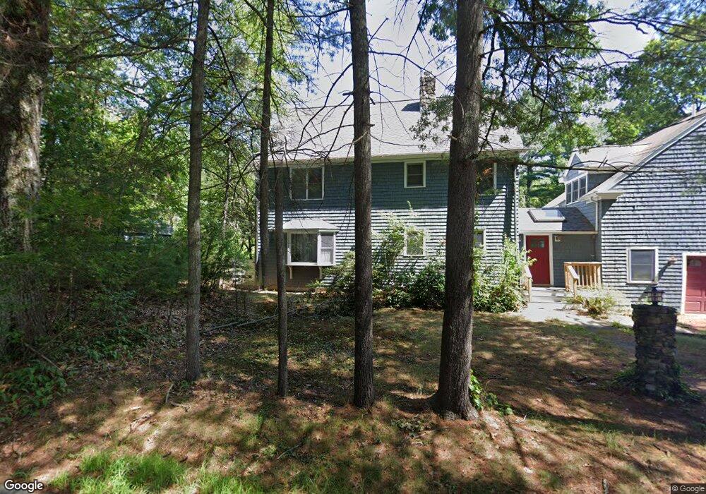
45 New Estate Rd Littleton, MA 01460
Estimated Value: $889,140 - $1,096,000
3
Beds
3
Baths
3,034
Sq Ft
$326/Sq Ft
Est. Value
About This Home
This home is located at 45 New Estate Rd, Littleton, MA 01460 and is currently estimated at $988,785, approximately $325 per square foot. 45 New Estate Rd is a home located in Middlesex County with nearby schools including Shaker Lane Elementary School, Russell Street Elementary School, and Littleton Middle School.
Ownership History
Date
Name
Owned For
Owner Type
Purchase Details
Closed on
Jul 5, 2018
Sold by
Bourque Stephen R and Bourque Lynne
Bought by
Toolroom Lt
Current Estimated Value
Purchase Details
Closed on
Feb 21, 2001
Sold by
Gustin Robert C and Gustin Alison S
Bought by
Bourque Stephen R and Davis Lynne
Purchase Details
Closed on
Feb 8, 1993
Sold by
Balogh Adam G and Hurstak Kelly A
Bought by
Gustin Robert C and Gustin Alison S
Purchase Details
Closed on
Sep 26, 1991
Sold by
North Middlesex Bank
Bought by
Hurstak Balogh Adam G and Kelly Hurstak
Create a Home Valuation Report for This Property
The Home Valuation Report is an in-depth analysis detailing your home's value as well as a comparison with similar homes in the area
Home Values in the Area
Average Home Value in this Area
Purchase History
| Date | Buyer | Sale Price | Title Company |
|---|---|---|---|
| Toolroom Lt | -- | -- | |
| Bourque Stephen R | $339,900 | -- | |
| Gustin Robert C | $120,000 | -- | |
| Hurstak Balogh Adam G | $99,000 | -- |
Source: Public Records
Mortgage History
| Date | Status | Borrower | Loan Amount |
|---|---|---|---|
| Previous Owner | Hurstak Balogh Adam G | $75,000 | |
| Previous Owner | Hurstak Balogh Adam G | $236,500 |
Source: Public Records
Tax History Compared to Growth
Tax History
| Year | Tax Paid | Tax Assessment Tax Assessment Total Assessment is a certain percentage of the fair market value that is determined by local assessors to be the total taxable value of land and additions on the property. | Land | Improvement |
|---|---|---|---|---|
| 2025 | $112 | $754,300 | $257,100 | $497,200 |
| 2024 | $10,830 | $729,800 | $248,400 | $481,400 |
| 2023 | $10,145 | $624,300 | $222,300 | $402,000 |
| 2022 | $9,436 | $532,800 | $213,500 | $319,300 |
| 2021 | $8,808 | $497,600 | $207,000 | $290,600 |
| 2020 | $8,409 | $473,200 | $196,100 | $277,100 |
| 2019 | $8,215 | $450,400 | $170,000 | $280,400 |
| 2018 | $8,159 | $449,800 | $169,900 | $279,900 |
| 2017 | $8,006 | $441,100 | $161,200 | $279,900 |
| 2016 | $7,750 | $438,100 | $161,200 | $276,900 |
| 2015 | $7,236 | $399,800 | $139,400 | $260,400 |
Source: Public Records
Map
Nearby Homes
- 17 Hartwell Ave
- 18 Pleasant St
- 9 (Lt 44) Darrell Dr
- 3 Taylor St
- 0 Ayer Rd
- 336 King St Unit 105
- 36 Whitetail Way
- 221 Foster St
- 8 Edsel Rd
- 10 Baldwin Hill Rd
- 34 Baldwin Hill Rd
- 12 Paula Beth St
- 55 Jennifer St
- 150 Whitcomb Ave
- 115 Goldsmith St
- 4 Spectacle Pond Rd
- 4 Mars Place
- Lot 2 Strawberry Farm
- 17 Chestnut Ln
- 239 Ayer Rd Unit 16
- 41 New Estate Rd
- 50 New Estate Rd
- 51 New Estate Rd
- 34 New Estate Rd
- 40 New Estate Rd
- 52 New Estate Rd
- 25 New Estate Rd
- 1 Uplands Rd
- 54 New Estate Rd
- 57 New Estate Rd
- 96 King St
- 96 King St
- 2 Uplands Rd
- 59 New Estate Rd
- 3 Uplands Rd
- 30 New Estate Rd
- 21 New Estate Rd
- 100 King St
- 38 New Estate Rd
- 5 Uplands Rd