Estimated Value: $697,000 - $754,000
3
Beds
2
Baths
1,399
Sq Ft
$514/Sq Ft
Est. Value
About This Home
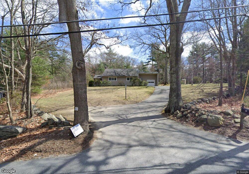
This home is located at 45 Piper Rd, Acton, MA 01720 and is currently estimated at $718,493, approximately $513 per square foot. 45 Piper Rd is a home located in Middlesex County with nearby schools including Acton-Boxborough Regional High School, Maynard Knowledge Beginnings, and The Imago School.
Ownership History
Date
Name
Owned For
Owner Type
Purchase Details
Closed on
Oct 26, 2012
Sold by
Newsham Elaine N
Bought by
Elaine N Newsham T N and Elaine Newsham
Current Estimated Value
Purchase Details
Closed on
Nov 24, 1999
Sold by
Newsham Walter B Est and Newsham
Bought by
Newsham Elaine N
Purchase Details
Closed on
Dec 21, 1994
Sold by
Newsham Walter B
Bought by
Distinctive Acton Home
Home Financials for this Owner
Home Financials are based on the most recent Mortgage that was taken out on this home.
Original Mortgage
$200,000
Interest Rate
9.19%
Mortgage Type
Purchase Money Mortgage
Create a Home Valuation Report for This Property
The Home Valuation Report is an in-depth analysis detailing your home's value as well as a comparison with similar homes in the area
Home Values in the Area
Average Home Value in this Area
Purchase History
| Date | Buyer | Sale Price | Title Company |
|---|---|---|---|
| Elaine N Newsham T N | -- | -- | |
| Distinctive Acton Home | $100,000 | -- | |
| Elaine N Newsham T N | -- | -- | |
| Newsham Elaine N | $114,925 | -- | |
| Distinctive Acton Home | $100,000 | -- |
Source: Public Records
Mortgage History
| Date | Status | Borrower | Loan Amount |
|---|---|---|---|
| Previous Owner | Distinctive Acton Home | $200,000 |
Source: Public Records
Tax History
| Year | Tax Paid | Tax Assessment Tax Assessment Total Assessment is a certain percentage of the fair market value that is determined by local assessors to be the total taxable value of land and additions on the property. | Land | Improvement |
|---|---|---|---|---|
| 2025 | $10,340 | $602,900 | $314,800 | $288,100 |
| 2024 | $9,832 | $589,800 | $314,800 | $275,000 |
| 2023 | $9,389 | $534,700 | $286,400 | $248,300 |
| 2022 | $9,480 | $487,400 | $249,600 | $237,800 |
| 2021 | $9,053 | $447,500 | $231,200 | $216,300 |
| 2020 | $8,493 | $441,400 | $231,200 | $210,200 |
| 2019 | $8,035 | $414,800 | $231,200 | $183,600 |
| 2018 | $7,521 | $388,100 | $231,200 | $156,900 |
| 2017 | $7,397 | $388,100 | $231,200 | $156,900 |
| 2016 | $7,084 | $368,400 | $231,200 | $137,200 |
| 2015 | $7,096 | $372,500 | $231,200 | $141,300 |
| 2014 | $7,125 | $366,300 | $231,200 | $135,100 |
Source: Public Records
Map
Nearby Homes
- 70 River St
- 1 Vanderbelt Rd
- 7 Hillcrest Dr
- 25 Nylander Way
- 30 Brewster Ln
- 40 High St
- 7 Kelley Rd
- 129 Main St Unit 129
- 131 Main St
- 184 Main St Unit 3
- 246 Main St Unit 2
- 128 Parker St Unit 3B
- 46 Taylor Rd
- 27 Forest Rd
- 31 Drummer Rd Unit 31
- 18 Hayward Rd
- 1 Drummer Rd Unit A5
- 59 Lexington Dr
- 11 Braebrook
- 303 School St
Your Personal Tour Guide
Ask me questions while you tour the home.