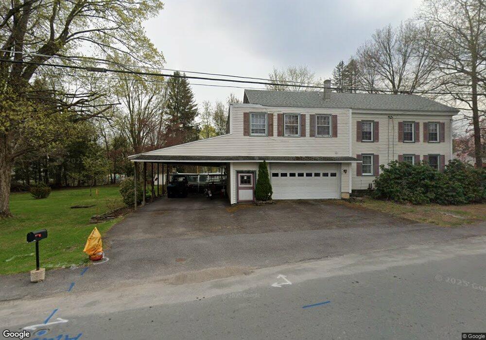
45 Po Box Waymart, PA 18472
Estimated Value: $211,000 - $302,000
3
Beds
2
Baths
1,518
Sq Ft
$162/Sq Ft
Est. Value
About This Home
This home is located at 45 Po Box, Waymart, PA 18472 and is currently estimated at $246,289, approximately $162 per square foot. 45 Po Box is a home located in Wayne County with nearby schools including Western Wayne High School.
Ownership History
Date
Name
Owned For
Owner Type
Purchase Details
Closed on
Aug 15, 2024
Sold by
May John J and May Heather L
Bought by
Foote Christian and Lauersen Kristin
Current Estimated Value
Home Financials for this Owner
Home Financials are based on the most recent Mortgage that was taken out on this home.
Original Mortgage
$255,189
Outstanding Balance
$252,345
Interest Rate
6.95%
Mortgage Type
FHA
Estimated Equity
-$6,056
Purchase Details
Closed on
Sep 20, 2018
Sold by
Romance Joanne W
Bought by
May John J and May Heather L
Home Financials for this Owner
Home Financials are based on the most recent Mortgage that was taken out on this home.
Original Mortgage
$69,600
Interest Rate
4.5%
Mortgage Type
New Conventional
Purchase Details
Closed on
Mar 23, 2009
Sold by
Estate Of Edna L Wiltz
Bought by
Romance Joanne W
Create a Home Valuation Report for This Property
The Home Valuation Report is an in-depth analysis detailing your home's value as well as a comparison with similar homes in the area
Home Values in the Area
Average Home Value in this Area
Purchase History
| Date | Buyer | Sale Price | Title Company |
|---|---|---|---|
| Foote Christian | $264,000 | Monroe Abstract | |
| May John J | $87,000 | None Available | |
| Romance Joanne W | -- | None Available |
Source: Public Records
Mortgage History
| Date | Status | Borrower | Loan Amount |
|---|---|---|---|
| Open | Foote Christian | $255,189 | |
| Previous Owner | May John J | $69,600 |
Source: Public Records
Tax History Compared to Growth
Tax History
| Year | Tax Paid | Tax Assessment Tax Assessment Total Assessment is a certain percentage of the fair market value that is determined by local assessors to be the total taxable value of land and additions on the property. | Land | Improvement |
|---|---|---|---|---|
| 2025 | $2,648 | $151,600 | $35,700 | $115,900 |
| 2024 | $2,527 | $151,600 | $35,700 | $115,900 |
| 2023 | $3,497 | $151,600 | $35,700 | $115,900 |
| 2022 | $1,937 | $75,600 | $19,400 | $56,200 |
| 2021 | $1,893 | $75,600 | $19,400 | $56,200 |
| 2020 | $1,873 | $75,600 | $19,400 | $56,200 |
| 2019 | $1,779 | $75,600 | $19,400 | $56,200 |
| 2018 | $1,769 | $75,600 | $19,400 | $56,200 |
| 2017 | $485 | $75,600 | $19,400 | $56,200 |
| 2016 | $1,718 | $75,600 | $19,400 | $56,200 |
| 2014 | -- | $75,600 | $19,400 | $56,200 |
Source: Public Records
Map
Nearby Homes
- 153 South St
- 0 US Highway 6
- 391 South St
- 8 Sleepy Hollow Rd
- 2669 Easton Turnpike
- 310 Stanton Dr
- 58 Salem View Dr
- 22 Salem View Dr
- 13 Bucklands Ln
- 20 Oak Ln
- 25 Old Gravity Rd
- 0 Robinson and Fox Rd
- 220 Salem Mountain Rd
- 708 Morse Ave
- 121 Delaware St
- 130 Salem Mountain Rd
- 65 River St
- 765 Elk Lake Dr
- 157 Creek Dr
- 27 Rittenhouse St