Estimated Value: $294,000 - $322,000
3
Beds
2
Baths
1,678
Sq Ft
$181/Sq Ft
Est. Value
About This Home
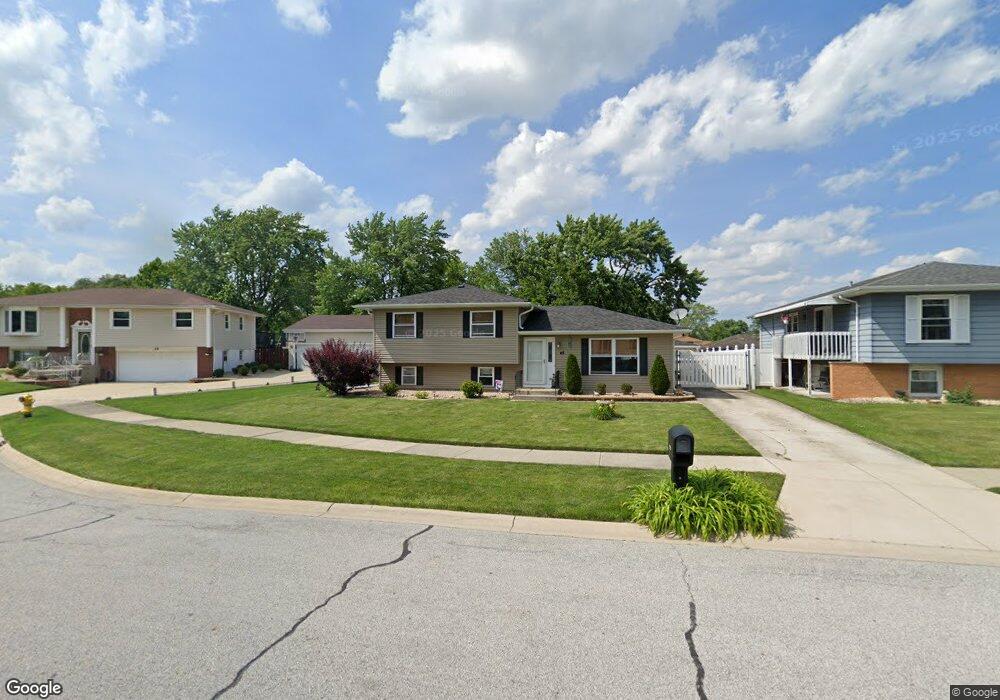
This home is located at 45 Potomac Dr, Dyer, IN 46311 and is currently estimated at $303,281, approximately $180 per square foot. 45 Potomac Dr is a home located in Lake County with nearby schools including Protsman Elementary School, Kahler Middle School, and Lake Central High School.
Ownership History
Date
Name
Owned For
Owner Type
Purchase Details
Closed on
Jun 12, 2015
Sold by
Indiana Land Trust Co
Bought by
Salus David A
Current Estimated Value
Home Financials for this Owner
Home Financials are based on the most recent Mortgage that was taken out on this home.
Original Mortgage
$181,649
Outstanding Balance
$143,156
Interest Rate
4.25%
Mortgage Type
FHA
Estimated Equity
$160,125
Purchase Details
Closed on
Aug 9, 2010
Sold by
Schutzman Carl H and Schutzman Cheryl L
Bought by
Peoples Bank Land Trust 10346
Create a Home Valuation Report for This Property
The Home Valuation Report is an in-depth analysis detailing your home's value as well as a comparison with similar homes in the area
Home Values in the Area
Average Home Value in this Area
Purchase History
| Date | Buyer | Sale Price | Title Company |
|---|---|---|---|
| Salus David A | -- | Meridian Title Corp | |
| Peoples Bank Land Trust 10346 | -- | Fidelity Schererville |
Source: Public Records
Mortgage History
| Date | Status | Borrower | Loan Amount |
|---|---|---|---|
| Open | Salus David A | $181,649 |
Source: Public Records
Tax History
| Year | Tax Paid | Tax Assessment Tax Assessment Total Assessment is a certain percentage of the fair market value that is determined by local assessors to be the total taxable value of land and additions on the property. | Land | Improvement |
|---|---|---|---|---|
| 2025 | $2,488 | $255,500 | $68,300 | $187,200 |
| 2024 | $6,060 | $239,000 | $68,300 | $170,700 |
| 2023 | $2,488 | $238,300 | $68,300 | $170,000 |
| 2022 | $2,598 | $224,800 | $68,300 | $156,500 |
| 2021 | $2,126 | $196,100 | $68,300 | $127,800 |
| 2020 | $2,041 | $185,900 | $61,400 | $124,500 |
| 2019 | $1,875 | $171,800 | $30,700 | $141,100 |
| 2018 | $1,674 | $162,800 | $30,700 | $132,100 |
| 2017 | $1,604 | $166,400 | $30,700 | $135,700 |
| 2016 | $1,532 | $159,400 | $30,700 | $128,700 |
| 2014 | $3,358 | $163,100 | $30,700 | $132,400 |
| 2013 | $3,327 | $159,200 | $30,700 | $128,500 |
Source: Public Records
Map
Nearby Homes
- 483 Linda Ln Unit 483
- 458 Alanna Ln Unit 458
- 1341 Capri Ln
- 431 Alanna Ln
- 370 Linda Ln
- 1416 Sheffield Ave
- 901 Robin Ct
- 297 Pattie Ln
- 744 Michelle Dr Unit 744
- 539 Jennifer Dr Unit 539
- 590 Virginia Ave Unit 590
- 54 Bernina Ct
- 24 Chillon Dr
- 811 Bridge St Unit 811
- 602 Virginia Ave
- 564 Linda Ln Unit 564
- 809 Bridge St Unit 809
- 858 Valerie Dr
- 855 Valerie Dr Unit 855
- 828 Elizabeth Ave Unit 828
Your Personal Tour Guide
Ask me questions while you tour the home.