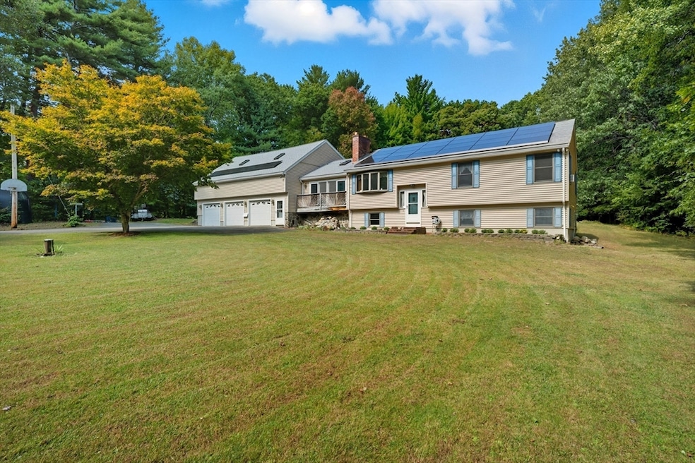
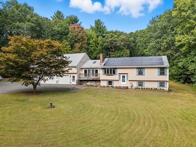
45 Red Gate Rd Tyngsboro, MA 01879
Estimated payment $4,448/month
Highlights
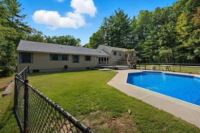
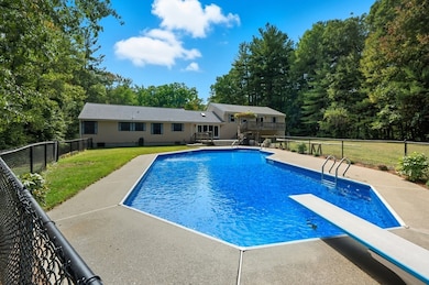
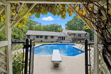
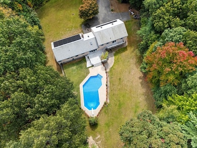
- In Ground Pool
- Deck
- 1 Fireplace
- 2.23 Acre Lot
- Wood Flooring
- Bonus Room
About This Home
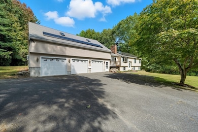
Welcome to your dream retreat! This beautifully appointed 4-bedroom, 2.5-bath home is set on 2.23 serene and private acres, offering the perfect balance of comfort, space, and convenience. Ideally located just minutes from the highway, you’ll enjoy quick access to shopping, dining, and everyday essentials—while still savoring the tranquility of a spacious, secluded lot. Enter to discover a warm and inviting layout designed for effortless everyday living and seamless entertaining. Sunlight fills the generously sized rooms, and there's plenty of space to grow, gather, and make lasting memories. But the real showstopper? A 3-car garage with over 1,000 sq. ft. of unfinished space above—ready to be transformed into a guest suite, accessory dwelling unit (ADU), home office, or the ultimate bonus room. With expansive outdoor space, endless potential, and unmatched versatility, this is more than just a home—it’s a rare opportunity to create the lifestyle you’ve always imagined.

Home Details
Home Type
- Single Family
Est. Annual Taxes
- $7,842
Year Built
- Built in 1985
Lot Details
- 2.23 Acre Lot
- Property is zoned R1
Parking
- 3 Car Attached Garage
- Driveway
- Open Parking
- Off-Street Parking
Home Design
- Split Level Home
- Shingle Roof
- Concrete Perimeter Foundation
Interior Spaces
- 1 Fireplace
- Bonus Room
Kitchen
- Range
- Microwave
- Dishwasher
- Trash Compactor
Flooring
- Wood
- Tile
Bedrooms and Bathrooms
- 4 Bedrooms
- Primary bedroom located on second floor
Laundry
- Laundry on main level
- Washer and Electric Dryer Hookup
Partially Finished Basement
- Walk-Out Basement
- Basement Fills Entire Space Under The House
- Garage Access
Outdoor Features
- In Ground Pool
- Deck
- Porch
Location
- Property is near schools
Utilities
- Window Unit Cooling System
- Heating System Uses Oil
- Pellet Stove burns compressed wood to generate heat
- Baseboard Heating
- 150 Amp Service
- Private Water Source
- Water Heater
- Private Sewer
Listing and Financial Details
- Tax Block 0091
- Assessor Parcel Number M:015 B:0091 L:0,810050
Community Details
Recreation
- Park
- Jogging Path
- Bike Trail
Additional Features
- No Home Owners Association
- Shops
Map
Home Values in the Area
Average Home Value in this Area
Tax History
| Year | Tax Paid | Tax Assessment Tax Assessment Total Assessment is a certain percentage of the fair market value that is determined by local assessors to be the total taxable value of land and additions on the property. | Land | Improvement |
|---|---|---|---|---|
| 2025 | $78 | $635,500 | $275,100 | $360,400 |
| 2024 | $7,855 | $617,500 | $268,000 | $349,500 |
| 2023 | $7,494 | $530,000 | $224,400 | $305,600 |
| 2022 | $7,192 | $481,400 | $196,100 | $285,300 |
| 2021 | $10,132 | $443,700 | $178,700 | $265,000 |
| 2020 | $12,841 | $422,200 | $170,000 | $252,200 |
| 2019 | $4,789 | $394,800 | $161,300 | $233,500 |
| 2018 | $6,613 | $386,500 | $161,300 | $225,200 |
| 2017 | $6,347 | $369,900 | $161,300 | $208,600 |
| 2016 | $6,206 | $353,400 | $161,300 | $192,100 |
| 2015 | $5,919 | $349,000 | $156,900 | $192,100 |
Property History
| Date | Event | Price | List to Sale | Price per Sq Ft |
|---|---|---|---|---|
| 10/08/2025 10/08/25 | Pending | -- | -- | -- |
| 10/01/2025 10/01/25 | For Sale | $719,900 | -- | $301 / Sq Ft |
Purchase History
| Date | Type | Sale Price | Title Company |
|---|---|---|---|
| Deed | $2,400 | -- | |
| Deed | $168,000 | -- |
Mortgage History
| Date | Status | Loan Amount | Loan Type |
|---|---|---|---|
| Open | $290,000 | No Value Available | |
| Closed | $238,000 | No Value Available |
Source: MLS Property Information Network (MLS PIN)
MLS Number: 73437975
APN: TYNG-000015-000091
Disclaimer: Certain information contained herein is derived from information provided by parties other than Homes.com. All information provided is deemed reliable, but is not guaranteed to be accurate and should be independently verified.
![]() The property listing data and information, or the Images, set forth herein were provided to MLS Property Information Network, Inc. from third party sources, including sellers, lessors and public records, and were compiled by MLS Property Information Network, Inc. The property listing data and information, and the Images, are for the personal, non-commercial use of consumers having a good faith interest in purchasing or leasing listed properties of the type displayed to them and may not be used for any purpose other than to identify prospective properties which such consumers may have a good faith interest in purchasing or leasing. MLS Property Information Network, Inc. and its subscribers disclaim any and all representations and warranties as to the accuracy of the property listing data and information, or as to the accuracy of any of the Images, set forth herein.
The property listing data and information, or the Images, set forth herein were provided to MLS Property Information Network, Inc. from third party sources, including sellers, lessors and public records, and were compiled by MLS Property Information Network, Inc. The property listing data and information, and the Images, are for the personal, non-commercial use of consumers having a good faith interest in purchasing or leasing listed properties of the type displayed to them and may not be used for any purpose other than to identify prospective properties which such consumers may have a good faith interest in purchasing or leasing. MLS Property Information Network, Inc. and its subscribers disclaim any and all representations and warranties as to the accuracy of the property listing data and information, or as to the accuracy of any of the Images, set forth herein.
- 454 Dunstable Rd
- 7 Axletree Rd
- 17 Cannongate Rd Unit 87
- 0 Dunstable Rd
- 0 Lowell St
- 19 Sandstone Rd
- 15 Stone Ridge Rd
- 20 Highland Rd
- 22 Highland Rd
- 76 Russells Way
- 23 Morrison Ln
- 10 Dickens Ln
- 24 Old Tyng Rd
- 46 Pawtucket Blvd Unit 38
- 6 Ingalls Rd
- 52 Pawtucket Blvd Unit 21
- 8 Hammock Dr Unit 8
- 11 Big Rock Trail
- 20 Merrimac Way Unit 20E
- 45 Riley Rd Unit 45