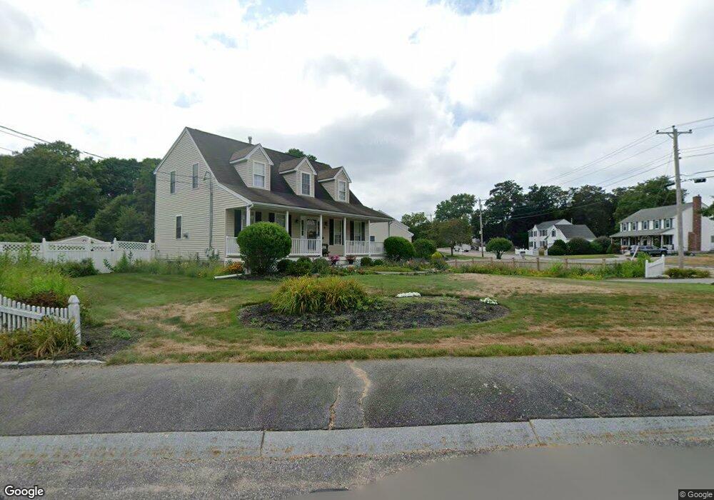
45 Sir Joseph Ct Taunton, MA 02780
Weir Village NeighborhoodEstimated Value: $610,000 - $624,667
3
Beds
3
Baths
1,685
Sq Ft
$365/Sq Ft
Est. Value
About This Home
This home is located at 45 Sir Joseph Ct, Taunton, MA 02780 and is currently estimated at $614,917, approximately $364 per square foot. 45 Sir Joseph Ct is a home located in Bristol County with nearby schools including Elizabeth Pole School, Taunton High School, and John F. Parker Middle School.
Ownership History
Date
Name
Owned For
Owner Type
Purchase Details
Closed on
May 1, 2025
Sold by
Clark Thomas A
Bought by
Clark Leigh-Beth
Current Estimated Value
Purchase Details
Closed on
Mar 14, 2025
Sold by
Clark Thomas A
Bought by
Clark Leah-Beth
Purchase Details
Closed on
Jul 31, 1997
Sold by
Clarewood Homes Inc
Bought by
Clark Thomas A
Create a Home Valuation Report for This Property
The Home Valuation Report is an in-depth analysis detailing your home's value as well as a comparison with similar homes in the area
Home Values in the Area
Average Home Value in this Area
Purchase History
| Date | Buyer | Sale Price | Title Company |
|---|---|---|---|
| Clark Leigh-Beth | -- | None Available | |
| Clark Leigh-Beth | -- | None Available | |
| Clark Leah-Beth | -- | None Available | |
| Clark Leah-Beth | -- | None Available | |
| Clark Thomas A | $161,400 | -- | |
| Clark Thomas A | $161,400 | -- |
Source: Public Records
Mortgage History
| Date | Status | Borrower | Loan Amount |
|---|---|---|---|
| Previous Owner | Clark Thomas A | $212,000 | |
| Previous Owner | Clark Thomas A | $130,000 | |
| Previous Owner | Clark Thomas A | $14,000 |
Source: Public Records
Tax History Compared to Growth
Tax History
| Year | Tax Paid | Tax Assessment Tax Assessment Total Assessment is a certain percentage of the fair market value that is determined by local assessors to be the total taxable value of land and additions on the property. | Land | Improvement |
|---|---|---|---|---|
| 2025 | $6,346 | $580,100 | $140,000 | $440,100 |
| 2024 | $5,784 | $516,900 | $159,100 | $357,800 |
| 2023 | $5,659 | $469,600 | $159,100 | $310,500 |
| 2022 | $5,405 | $410,100 | $137,900 | $272,200 |
| 2021 | $4,561 | $378,300 | $120,600 | $257,700 |
| 2020 | $5,142 | $346,000 | $120,600 | $225,400 |
| 2019 | $4,342 | $337,800 | $126,300 | $211,500 |
| 2018 | $5,079 | $323,100 | $127,600 | $195,500 |
| 2017 | $3,845 | $299,000 | $121,000 | $178,000 |
| 2016 | $4,533 | $289,100 | $117,400 | $171,700 |
| 2015 | $4,500 | $299,800 | $118,500 | $181,300 |
| 2014 | $4,256 | $291,300 | $117,500 | $173,800 |
Source: Public Records
Map
Nearby Homes
- 31 Bruno's Way Unit A
- 147 Colonial Dr
- 218R Hart St Unit B
- 26 Maynard St Unit A
- 170 Hart St Unit B
- 600 County St Lot A
- 600
- 600 County St
- 55 Donna Terrace
- 28 Barbara Rd
- 25 Johnson St Unit B
- 23 Johnson St Unit C
- 3 Karena Dr Unit 8
- 73 Raymond Ave
- 15 Carlton St
- 96 Old Colony Ave Unit 264
- 50 Azalea Dr Unit 50
- 96 Old Colony Ave Unit 227
- 96 Old Colony Ave Unit 318
- 96 Old Colony Ave Unit 158
- 51 Round Table Ln
- 35 Sir Joseph Ct
- LOT 247A Roundtable Ln
- 34 Round Table Ln
- 50 Round Table Ln
- 21 Round Table Ln
- 25 Sir Joseph Ct
- 24 Round Table Ln
- 61 Round Table Ln
- 36 Sir Joseph Ct
- 26 Sir Joseph Ct
- LOT 247B Roundtable Ln
- 14 Round Table Ln
- 64 Round Table Ln
- 71 Round Table Ln
- 162 Williams St
- 7 Round Table Ln
- 164 Williams St
- 160 Williams St
- 74 Round Table Ln