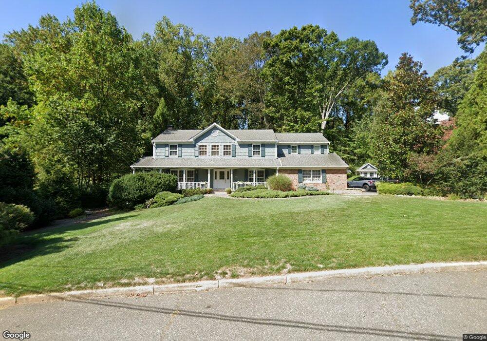
45 Tall Tree Rd Middletown, NJ 07748
New Monmouth NeighborhoodEstimated Value: $1,037,000 - $1,183,000
4
Beds
2
Baths
3,017
Sq Ft
$359/Sq Ft
Est. Value
About This Home
This home is located at 45 Tall Tree Rd, Middletown, NJ 07748 and is currently estimated at $1,081,905, approximately $358 per square foot. 45 Tall Tree Rd is a home located in Monmouth County with nearby schools including Nut Swamp Elementary School, Thompson Middle School, and Middletown - South High School.
Ownership History
Date
Name
Owned For
Owner Type
Purchase Details
Closed on
Feb 6, 2012
Sold by
Sullivan Alina M and Sullivan Christopher S
Bought by
Reagan Christopher M and Reagan Sharon M
Current Estimated Value
Home Financials for this Owner
Home Financials are based on the most recent Mortgage that was taken out on this home.
Original Mortgage
$532,000
Outstanding Balance
$365,695
Interest Rate
3.96%
Mortgage Type
New Conventional
Estimated Equity
$716,210
Purchase Details
Closed on
Nov 30, 1989
Bought by
Goodman Michael and Goodman Audrey
Create a Home Valuation Report for This Property
The Home Valuation Report is an in-depth analysis detailing your home's value as well as a comparison with similar homes in the area
Home Values in the Area
Average Home Value in this Area
Purchase History
| Date | Buyer | Sale Price | Title Company |
|---|---|---|---|
| Reagan Christopher M | $665,000 | Stewart Title Guaranty Co | |
| Goodman Michael | $300,000 | -- |
Source: Public Records
Mortgage History
| Date | Status | Borrower | Loan Amount |
|---|---|---|---|
| Open | Reagan Christopher M | $532,000 |
Source: Public Records
Tax History Compared to Growth
Tax History
| Year | Tax Paid | Tax Assessment Tax Assessment Total Assessment is a certain percentage of the fair market value that is determined by local assessors to be the total taxable value of land and additions on the property. | Land | Improvement |
|---|---|---|---|---|
| 2025 | $14,910 | $1,011,500 | $548,500 | $463,000 |
| 2024 | $15,685 | $906,400 | $445,500 | $460,900 |
| 2023 | $15,685 | $902,500 | $416,600 | $485,900 |
| 2022 | $14,329 | $756,300 | $293,600 | $462,700 |
| 2021 | $14,329 | $688,900 | $277,400 | $411,500 |
| 2020 | $14,344 | $670,900 | $268,700 | $402,200 |
| 2019 | $14,121 | $668,600 | $268,700 | $399,900 |
| 2018 | $13,823 | $637,900 | $258,400 | $379,500 |
| 2017 | $13,309 | $626,600 | $253,700 | $372,900 |
| 2016 | $13,658 | $640,900 | $277,400 | $363,500 |
| 2015 | $13,164 | $616,300 | $258,400 | $357,900 |
| 2014 | $12,609 | $576,000 | $248,900 | $327,100 |
Source: Public Records
Map
Nearby Homes
- 93 Wallace Rd
- 74 Fish Hawk Dr
- 164 Heights Terrace
- 8 Church St
- 20 Cormorant Dr
- 7 Cormorant Dr
- 17 Winding Brook Way
- 93 Twin Brooks Ave
- 83 Green Meadow Blvd
- 234 Borden Rd
- 20 Devon Rd
- 11 Mayflower Dr
- 911 Middletown Lincroft Rd
- 78 Ironwood Ct
- 35 Woodland Dr
- 45 Galloping Hill Cir
- 185 Ballantine Rd
- 4 Takolusa Dr
- 0 Hamiltonian Dr Unit 22514980
- 17 Terry Ln