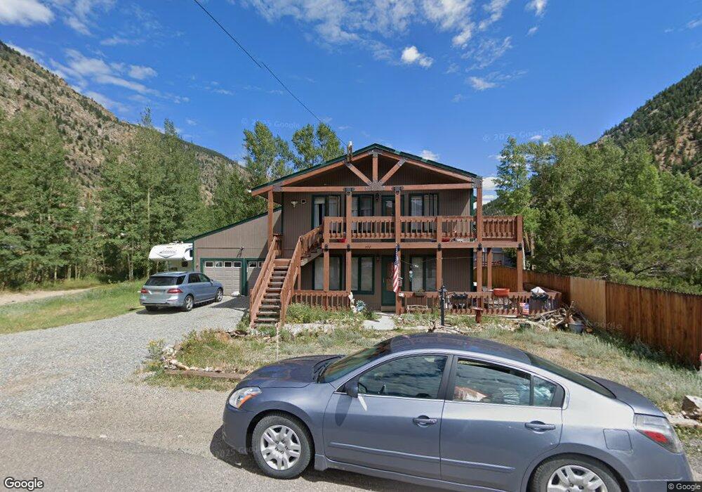
450 15th St Unit 1 Georgetown, CO 80444
Estimated Value: $494,000 - $770,000
4
Beds
2
Baths
1,904
Sq Ft
$337/Sq Ft
Est. Value
About This Home
This home is located at 450 15th St Unit 1, Georgetown, CO 80444 and is currently estimated at $640,870, approximately $336 per square foot. 450 15th St Unit 1 is a home located in Clear Creek County with nearby schools including Clear Creek Middle School, Clear Creek High School, and Georgetown Community School.
Ownership History
Date
Name
Owned For
Owner Type
Purchase Details
Closed on
Sep 17, 2024
Sold by
Fickes Robin C
Bought by
Muckler Keith
Current Estimated Value
Purchase Details
Closed on
Mar 28, 2016
Sold by
Berrien William T
Bought by
Fickes Robin C
Home Financials for this Owner
Home Financials are based on the most recent Mortgage that was taken out on this home.
Original Mortgage
$240,000
Interest Rate
3.65%
Mortgage Type
New Conventional
Purchase Details
Closed on
Dec 30, 2013
Sold by
Gilbert Brian W
Bought by
Berrien William T
Home Financials for this Owner
Home Financials are based on the most recent Mortgage that was taken out on this home.
Original Mortgage
$162,400
Interest Rate
4.36%
Mortgage Type
New Conventional
Create a Home Valuation Report for This Property
The Home Valuation Report is an in-depth analysis detailing your home's value as well as a comparison with similar homes in the area
Home Values in the Area
Average Home Value in this Area
Purchase History
| Date | Buyer | Sale Price | Title Company |
|---|---|---|---|
| Muckler Keith | $675,000 | Land Title Guarantee | |
| Fickes Robin C | $300,000 | Land Title Guarantee Company | |
| Berrien William T | $203,000 | Chicago Title Co |
Source: Public Records
Mortgage History
| Date | Status | Borrower | Loan Amount |
|---|---|---|---|
| Previous Owner | Fickes Robin C | $240,000 | |
| Previous Owner | Berrien William T | $162,400 |
Source: Public Records
Tax History Compared to Growth
Tax History
| Year | Tax Paid | Tax Assessment Tax Assessment Total Assessment is a certain percentage of the fair market value that is determined by local assessors to be the total taxable value of land and additions on the property. | Land | Improvement |
|---|---|---|---|---|
| 2024 | $2,148 | $27,660 | $1,890 | $25,770 |
| 2023 | $2,141 | $27,660 | $1,890 | $25,770 |
| 2022 | $2,177 | $27,920 | $2,230 | $25,690 |
| 2021 | $2,169 | $28,720 | $2,290 | $26,430 |
| 2020 | $1,605 | $22,270 | $2,290 | $19,980 |
| 2019 | $1,602 | $22,270 | $2,290 | $19,980 |
| 2018 | $1,340 | $19,410 | $2,310 | $17,100 |
| 2017 | $1,391 | $19,410 | $2,310 | $17,100 |
| 2016 | $1,039 | $14,490 | $1,850 | $12,640 |
| 2015 | -- | $14,490 | $1,850 | $12,640 |
| 2014 | -- | $18,620 | $3,320 | $15,300 |
Source: Public Records
Map
Nearby Homes
- 1500 Buckeye Cir
- 1418 Rose St
- 0 Skyline Rd
- 1463 Main St
- 1431 Marion St
- 1406 Argentine St
- 000 Main St
- 1206 Rose St
- 1890 Argentine St Unit 303
- 1890 Argentine St Unit A104
- 0002 Cosmos
- 0001 Americ
- 1901 Clear Creek Dr Unit A204
- 1901 Clear Creek Dr Unit 301
- South Lot Clear Creek Dr
- 1016-7 Biddle St
- 0 Clear Creek Unit REC7593075
- 611 Blue Spruce Ln Unit 150
- 906 Main St
- 203 9th St
- 450 15th St
- 0 15th St Unit 2217354
- 1575 Buckeye Cir
- 1555 Buckeye Cir
- 1535 Buckeye Cir
- 1515 Buckeye Cir
- 1500 Argentine St
- 1494 Rose St
- 1501 Buckeye Cir
- 1492 Rose St
- 1490 Rose St
- 1510 Argentine St
- 1550 Buckeye Cir
- 1540 Buckeye Cir
- 1560 Buckeye Cir
- 375 15th St
- 1530 Buckeye Cir
- 363 15th St
- 1580 Buckeye Cir
- 1570 Buckeye Cir