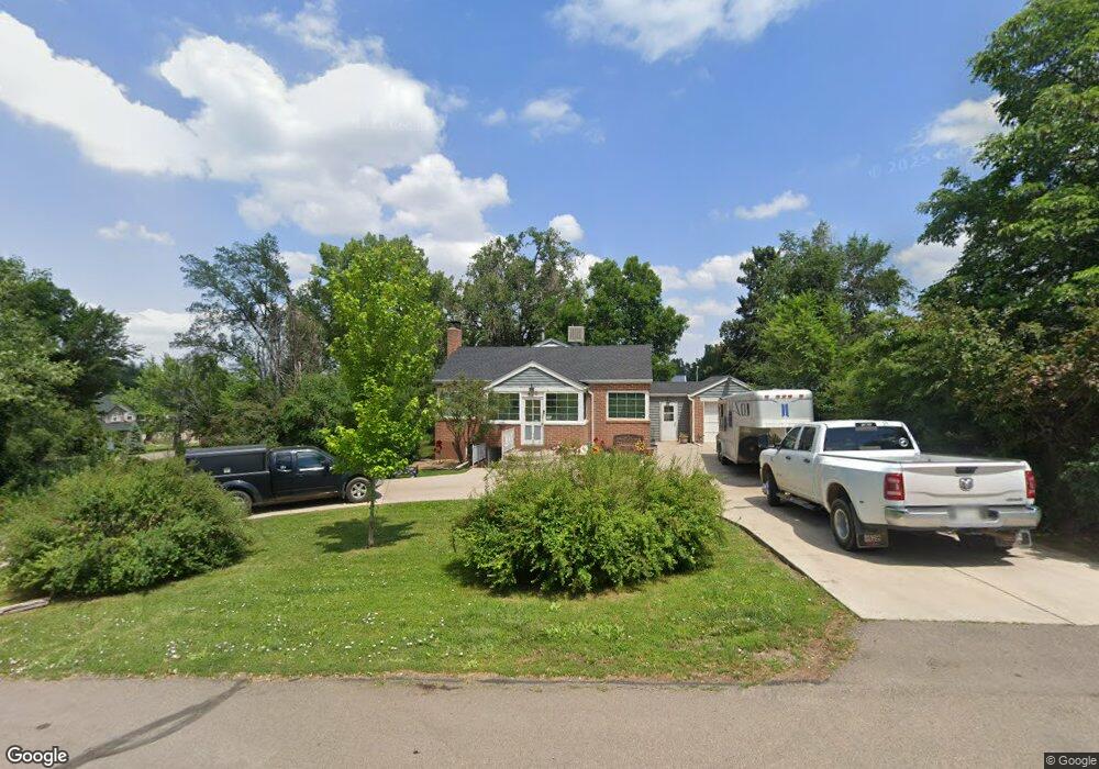
450 Balsam St Lakewood, CO 80226
Creighton NeighborhoodEstimated Value: $668,506 - $880,000
4
Beds
2
Baths
2,176
Sq Ft
$352/Sq Ft
Est. Value
About This Home
This home is located at 450 Balsam St, Lakewood, CO 80226 and is currently estimated at $764,877, approximately $351 per square foot. 450 Balsam St is a home located in Jefferson County with nearby schools including South Lakewood Elementary School, Creighton Middle School, and Lakewood High School.
Ownership History
Date
Name
Owned For
Owner Type
Purchase Details
Closed on
Sep 7, 2023
Sold by
Sandstead Carol A
Bought by
Sandstead Properties 450 Llc
Current Estimated Value
Purchase Details
Closed on
Mar 25, 2015
Sold by
Kretsch Barbara H
Bought by
Sandstead Carol A
Home Financials for this Owner
Home Financials are based on the most recent Mortgage that was taken out on this home.
Original Mortgage
$334,000
Interest Rate
3.73%
Mortgage Type
New Conventional
Purchase Details
Closed on
Sep 30, 2013
Sold by
Kern Steven L and Kern Robin L
Bought by
Sandstead Carol A and Kretsch Barbara H
Home Financials for this Owner
Home Financials are based on the most recent Mortgage that was taken out on this home.
Original Mortgage
$297,500
Interest Rate
4.62%
Mortgage Type
New Conventional
Purchase Details
Closed on
Jun 5, 2009
Sold by
Davis Mary D
Bought by
Kern Steven L and Kern Robin L
Home Financials for this Owner
Home Financials are based on the most recent Mortgage that was taken out on this home.
Original Mortgage
$252,000
Interest Rate
4.84%
Mortgage Type
Purchase Money Mortgage
Create a Home Valuation Report for This Property
The Home Valuation Report is an in-depth analysis detailing your home's value as well as a comparison with similar homes in the area
Home Values in the Area
Average Home Value in this Area
Purchase History
| Date | Buyer | Sale Price | Title Company |
|---|---|---|---|
| Sandstead Properties 450 Llc | -- | None Listed On Document | |
| Sandstead Carol A | -- | None Available | |
| Sandstead Carol A | $425,000 | Homestead Title & Escrow | |
| Kern Steven L | $315,000 | Vanguard National Title Inc |
Source: Public Records
Mortgage History
| Date | Status | Borrower | Loan Amount |
|---|---|---|---|
| Previous Owner | Sandstead Carol A | $334,000 | |
| Previous Owner | Sandstead Carol A | $297,500 | |
| Previous Owner | Kern Steven L | $252,000 |
Source: Public Records
Tax History Compared to Growth
Tax History
| Year | Tax Paid | Tax Assessment Tax Assessment Total Assessment is a certain percentage of the fair market value that is determined by local assessors to be the total taxable value of land and additions on the property. | Land | Improvement |
|---|---|---|---|---|
| 2024 | $4,493 | $49,819 | $30,041 | $19,778 |
| 2023 | $4,493 | $49,819 | $30,041 | $19,778 |
| 2022 | $3,274 | $35,493 | $19,577 | $15,916 |
| 2021 | $3,321 | $36,514 | $20,140 | $16,374 |
| 2020 | $2,415 | $26,669 | $18,256 | $8,413 |
| 2019 | $2,902 | $32,467 | $18,256 | $14,211 |
| 2018 | $2,408 | $26,057 | $12,124 | $13,933 |
| 2017 | $2,116 | $26,057 | $12,124 | $13,933 |
| 2016 | $2,485 | $28,275 | $14,767 | $13,508 |
| 2015 | $2,392 | $28,275 | $14,767 | $13,508 |
| 2014 | $2,392 | $25,179 | $14,282 | $10,897 |
Source: Public Records
Map
Nearby Homes
- 653 Brentwood St
- 630 Estes St
- 135 Dover St
- 65 Cody St
- 7785 Westview Dr
- 105 Dudley St
- 8060 W 9th Ave Unit 107
- 765 Emerald Ln
- 444 Vance St Unit E6
- 35 S Cody St
- 562 Vance St Unit D9
- 548 Vance St Unit B10
- 7223 W 1st Place
- 8516 W 10th Ave
- 25 S Wadsworth Blvd
- 8542 W 10th Ave
- 730 Crescent Ln
- 130 Garrison St
- 75 S Estes St
- 1021 Carr St Unit 22