
Seller's Agent in 2025
The Stacey Group
eXp Realty
(770) 843-4687
6 in this area
116 Total Sales
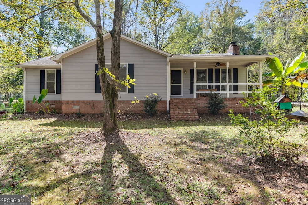
Country Retreat on 10 acres in Carroll County. Discover the perfect blend of comfort, space, and country living with this beautiful home set on 10 acres in Carroll County. Step inside to a spacious living room featuring a cozy fireplace-an inviting spot for family gathering and holiday celebrations. Just off the living area is a large eat-in kitchen with stained cabinets and a generous island, ideal for meal prep or casual dining. A convenient laundry room and an enclosed back porch, perfect for plant enthusiasts, are located nearby. The home offers plenty of room for entaining, with a large recreation room complete with a full bath and easy access to the private backyard. Down the front hallway, you'll find two oversized bedrooms and a hall bath. The master suite features a walk-in closet and a private bath with a tub/shower combination. Outdoors, the property is just as impressive. A storage shed keeps yard tools organized, while a 40 X 40 metal building with two roll-up doors, a concrete floor, electricity, and running water provides endless possibilities for hobbies, projects, or extra storage. The land is partially fenced, making it a fantastic option for families with animals. Located in sought-after Carroll County, the property offers the peace of rural living while still being close to modern conveniences. Carroll County is known for its rolling farmland, community spirit, and access to recreation--including near by lakes, hiking trails and historic downtown Carrollton. Families will appreciate that this home is zoned for Roopville Elementary and Central Middle/High Schools, all well-regarded for their strong academic programs, athletics and supportive community environment. This is more than a home--it's a lifestyle. Come see everything this Carroll County property has to offer. Carrier A/C has a manufactured date of 2024.
| Date | Type | Sale Price | Title Company |
|---|---|---|---|
| Limited Warranty Deed | $420,000 | -- | |
| Quit Claim Deed | -- | -- | |
| Deed | $205,000 | -- | |
| Deed | -- | -- | |
| Deed | -- | -- | |
| Deed | $120,000 | -- | |
| Deed | -- | -- | |
| Deed | -- | -- |
| Date | Event | Price | List to Sale | Price per Sq Ft |
|---|---|---|---|---|
| 12/15/2025 12/15/25 | Sold | $420,000 | -15.2% | $158 / Sq Ft |
| 12/07/2025 12/07/25 | Pending | -- | -- | -- |
| 10/08/2025 10/08/25 | For Sale | $495,000 | -- | $186 / Sq Ft |
| Year | Tax Paid | Tax Assessment Tax Assessment Total Assessment is a certain percentage of the fair market value that is determined by local assessors to be the total taxable value of land and additions on the property. | Land | Improvement |
|---|---|---|---|---|
| 2025 | $435 | $158,362 | $43,397 | $114,965 |
| 2024 | $440 | $158,362 | $43,397 | $114,965 |
| 2023 | $440 | $140,383 | $34,718 | $105,665 |
| 2022 | $401 | $107,951 | $23,145 | $84,806 |
| 2021 | $432 | $92,707 | $18,516 | $74,191 |
| 2020 | $1,672 | $81,790 | $16,833 | $64,957 |
| 2019 | $1,599 | $77,089 | $16,833 | $60,256 |
| 2018 | $421 | $69,449 | $15,732 | $53,717 |
| 2017 | $425 | $69,449 | $15,732 | $53,717 |
| 2016 | $424 | $69,449 | $15,732 | $53,717 |
| 2015 | $433 | $75,775 | $22,656 | $53,120 |
| 2014 | $436 | $75,775 | $22,656 | $53,120 |
Seller's Agent in 2025
The Stacey Group
eXp Realty
(770) 843-4687
6 in this area
116 Total Sales
Buyer's Agent in 2025
Machelle Payton-Holl
Virtual Properties Realty.com
(770) 856-9846
1 in this area
97 Total Sales
Source: Georgia MLS
MLS Number: 10617779
APN: 064-0044
Disclaimer: Certain information contained herein is derived from information provided by parties other than Homes.com. All information provided is deemed reliable, but is not guaranteed to be accurate and should be independently verified.
![]() The data relating to real estate for sale on this web site comes in part from the Broker Reciprocity Program of Georgia MLS. Real estate listings held by brokerage firms other than Redfin are marked with the Broker Reciprocity logo and detailed information about them includes the name of the listing brokers. Information deemed reliable but not guaranteed. Copyright 2026 Georgia MLS. All rights reserved.
The data relating to real estate for sale on this web site comes in part from the Broker Reciprocity Program of Georgia MLS. Real estate listings held by brokerage firms other than Redfin are marked with the Broker Reciprocity logo and detailed information about them includes the name of the listing brokers. Information deemed reliable but not guaranteed. Copyright 2026 Georgia MLS. All rights reserved.
Ask me questions while you tour the home.