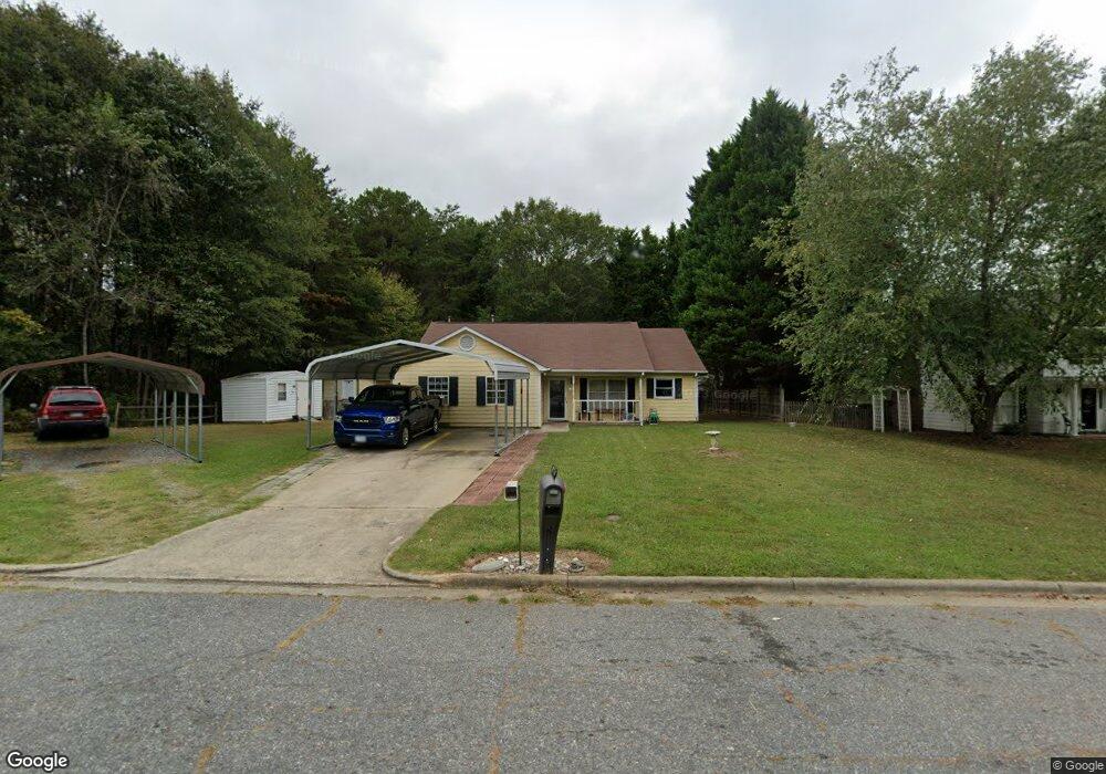
450 Burrington Ct Gastonia, NC 28054
Estimated Value: $323,000 - $335,000
3
Beds
2
Baths
1,790
Sq Ft
$184/Sq Ft
Est. Value
About This Home
This home is located at 450 Burrington Ct, Gastonia, NC 28054 and is currently estimated at $329,350, approximately $183 per square foot. 450 Burrington Ct is a home located in Gaston County with nearby schools including Lingerfeldt Elementary School, Southwest Middle School, and Forestview High School.
Ownership History
Date
Name
Owned For
Owner Type
Purchase Details
Closed on
Jun 21, 2023
Sold by
Sadler Joe L and Sadler Angela N
Bought by
Sadler Family Living Trust and Sadler
Current Estimated Value
Purchase Details
Closed on
May 30, 2008
Sold by
Barnes Ivey T and Barnes Leslie M
Bought by
Sadler Joe L and Sadler Angela N
Home Financials for this Owner
Home Financials are based on the most recent Mortgage that was taken out on this home.
Original Mortgage
$136,500
Interest Rate
5.86%
Mortgage Type
VA
Create a Home Valuation Report for This Property
The Home Valuation Report is an in-depth analysis detailing your home's value as well as a comparison with similar homes in the area
Home Values in the Area
Average Home Value in this Area
Purchase History
| Date | Buyer | Sale Price | Title Company |
|---|---|---|---|
| Sadler Family Living Trust | -- | None Listed On Document | |
| Sadler Joe L | $136,500 | None Available |
Source: Public Records
Mortgage History
| Date | Status | Borrower | Loan Amount |
|---|---|---|---|
| Previous Owner | Sadler Joe L | $136,500 |
Source: Public Records
Tax History Compared to Growth
Tax History
| Year | Tax Paid | Tax Assessment Tax Assessment Total Assessment is a certain percentage of the fair market value that is determined by local assessors to be the total taxable value of land and additions on the property. | Land | Improvement |
|---|---|---|---|---|
| 2025 | $2,657 | $293,550 | $21,500 | $272,050 |
| 2024 | $2,657 | $293,550 | $21,500 | $272,050 |
| 2023 | $2,684 | $293,550 | $21,500 | $272,050 |
| 2022 | $1,603 | $165,500 | $20,000 | $145,500 |
| 2021 | $1,627 | $165,500 | $20,000 | $145,500 |
| 2019 | $1,571 | $160,530 | $20,000 | $140,530 |
| 2018 | $1,188 | $129,823 | $17,600 | $112,223 |
| 2017 | $1,818 | $129,823 | $17,600 | $112,223 |
| 2016 | $1,818 | $129,823 | $0 | $0 |
| 2014 | $1,808 | $129,158 | $26,500 | $102,658 |
Source: Public Records
Map
Nearby Homes
- 407 Rowan Ct
- 2491 Loch Stone Dr
- 2408 Cagle Ct
- 921 Ashworth Dr
- 929 Claybrook Cir
- 926 Claybrook Cir
- 602 Westover St
- 577 Tryon Place
- 664 Tryon Place
- 2397 Osprey Ct
- 2238 Swain Ct
- Plan 1817 Townhome at Pine Trace
- Plan 1879 Townhome at Pine Trace
- Plan 1514 Townhome at Pine Trace
- 4077 Port Richmond Ave Unit 18
- 4069 Port Richmond Ave Unit 16
- 542 Queen Brogan Ct
- 4045 Port Richmond Ave Unit 10
- 4003 Northerly Island Ct
- 4041 Port Richmond Ave Unit 9
- 460 Burrington Ct
- 2447 Caswell Ct
- 2501 Caswell Ct
- 449 Burrington Ct
- 2439 Caswell Ct Unit 27
- 2460 Caswell Ct
- 2450 Caswell Ct
- 2509 Caswell Ct
- 2500 Caswell Ct
- 2431 Caswell Ct
- 2440 Caswell Ct
- 416 Iredell Ct
- 514 Burrington Ct
- 408 Iredell Ct
- 2517 Caswell Ct
- 2510 Caswell Ct
- 2432 Caswell Ct
- 2423 Caswell Ct
- 522 Burrington Ct
- 511 Burrington Ct