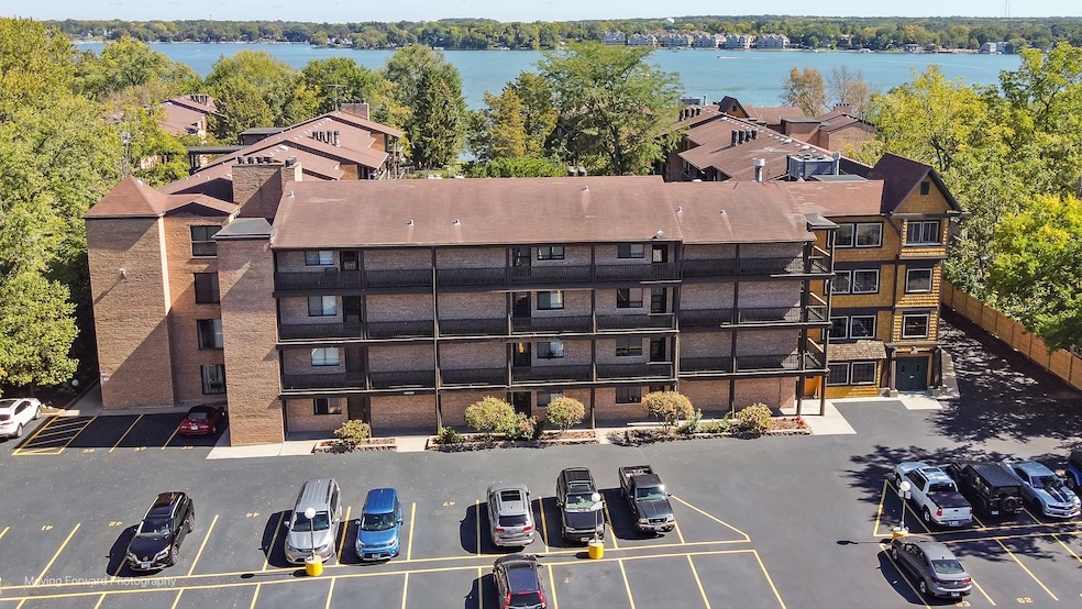

450 N Main St Unit S208A Wauconda, IL 60084
Estimated payment $1,631/month
Highlights
- Water Views
- Above Ground Pool
- Party Room
- Boat Dock
- Lock-and-Leave Community
- Elevator
About This Home
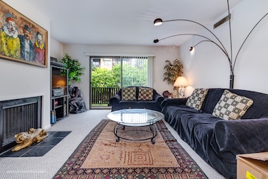
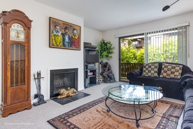
**Priced Reduced To Sell** Live Where Others Vacation - Lakefront Living at Harbour Club! This condo has two large balconies with stunning views overlooking the pool and the courtyard, with a view of the lake from the kitchen window. Located in the heart of Wauconda, this condo offers exclusive access to a beach, pool & private pier with boat slips for just $600 per season. Enjoy morning strolls to Wauconda's charming downtown for coffee, dining, and boutique shopping - all just steps away. Whether you love boating, fishing, paddleboarding, or relaxing by the water, Harbour Club is your year-round escape. Please note: owner-occupants only (rentals not permitted). Motivated seller - bring your offer today and start living the lake life you've always wanted!
Property Details
Home Type
- Condominium
Est. Annual Taxes
- $2,899
Year Built
- Built in 1974
HOA Fees
- $602 Monthly HOA Fees
Home Design
- Entry on the 2nd floor
- Brick Exterior Construction
- Asphalt Roof
- Concrete Perimeter Foundation
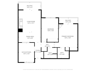
Interior Spaces
- 1,102 Sq Ft Home
- 4-Story Property
- Wood Burning Fireplace
- Family Room
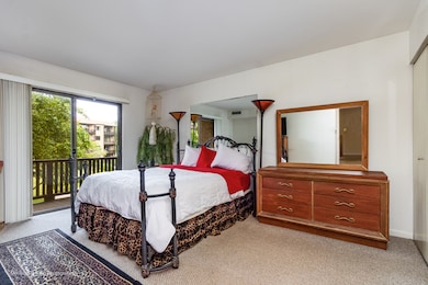
- Living Room with Fireplace
- Dining Room
- Carpet
- Water Views
- Laundry Room
Bedrooms and Bathrooms
- 2 Bedrooms
- 2 Potential Bedrooms
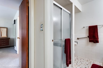
- 2 Full Bathrooms
Parking
- 1 Parking Space
- Driveway
- Parking Included in Price
- Assigned Parking
Outdoor Features
- Above Ground Pool
- Tideland Water Rights
- Balcony
Schools
- Wauconda Elementary School
- Wauconda Middle School
- Wauconda Comm High School
Utilities
- Central Air
- Heating System Uses Natural Gas
- 100 Amp Service
- Shared Well
Community Details
Overview
- Association fees include heat, water, insurance, clubhouse, pool, exterior maintenance, lawn care, scavenger, snow removal, lake rights
- 91 Units
- Property Manager Association, Phone Number (847) 259-1331
- Harbour Club Subdivision
- Property managed by McGill Management
- Lock-and-Leave Community
Amenities
- Party Room
- Coin Laundry
- Elevator
- Community Storage Space
Recreation
- Boat Dock
- Community Pool
Pet Policy
- No Pets Allowed
Security
- Resident Manager or Management On Site
Map
Home Values in the Area
Average Home Value in this Area
Tax History
| Year | Tax Paid | Tax Assessment Tax Assessment Total Assessment is a certain percentage of the fair market value that is determined by local assessors to be the total taxable value of land and additions on the property. | Land | Improvement |
|---|---|---|---|---|
| 2024 | $2,842 | $42,587 | $4,260 | $38,327 |
| 2023 | $3,278 | $38,928 | $3,894 | $35,034 |
| 2022 | $3,278 | $38,037 | $4,157 | $33,880 |
| 2021 | $3,215 | $37,042 | $3,928 | $33,114 |
| 2020 | $3,422 | $38,330 | $3,744 | $34,586 |
| 2019 | $3,260 | $38,524 | $3,538 | $34,986 |
| 2018 | $1,994 | $25,378 | $3,808 | $21,570 |
| 2017 | $1,988 | $25,085 | $3,764 | $21,321 |
| 2016 | $1,826 | $23,754 | $3,564 | $20,190 |
| 2015 | $1,651 | $21,807 | $3,272 | $18,535 |
| 2014 | $1,041 | $19,645 | $3,438 | $16,207 |
| 2012 | $1,072 | $16,914 | $3,290 | $13,624 |
Property History
| Date | Event | Price | List to Sale | Price per Sq Ft |
|---|---|---|---|---|
| 10/15/2025 10/15/25 | Pending | -- | -- | -- |
| 09/27/2025 09/27/25 | Price Changed | $149,000 | -10.8% | $135 / Sq Ft |
| 09/22/2025 09/22/25 | Price Changed | $167,000 | -5.6% | $152 / Sq Ft |
| 09/12/2025 09/12/25 | For Sale | $177,000 | 0.0% | $161 / Sq Ft |
| 08/04/2025 08/04/25 | Pending | -- | -- | -- |
| 06/28/2025 06/28/25 | For Sale | $177,000 | -- | $161 / Sq Ft |
Purchase History
| Date | Type | Sale Price | Title Company |
|---|---|---|---|
| Warranty Deed | -- | None Available | |
| Warranty Deed | $53,000 | Baird & Warner Title Service | |
| Interfamily Deed Transfer | -- | Chicago Title Insurance Co | |
| Trustee Deed | $48,666 | Plm Title Company |
Source: Midwest Real Estate Data (MRED)
MLS Number: 12405094
APN: 09-26-204-111
Disclaimer: Certain information contained herein is derived from information provided by parties other than Homes.com. All information provided is deemed reliable, but is not guaranteed to be accurate and should be independently verified.
![]() Based on information submitted to the MLS GRID. All data is obtained from various sources and may not have been verified by broker or MLS GRID. Supplied Open House Information is subject to change without notice. All information should be independently reviewed and verified for accuracy. Properties may or may not be listed by the office/agent presenting the information. Some IDX listings have been excluded from this website.
Based on information submitted to the MLS GRID. All data is obtained from various sources and may not have been verified by broker or MLS GRID. Supplied Open House Information is subject to change without notice. All information should be independently reviewed and verified for accuracy. Properties may or may not be listed by the office/agent presenting the information. Some IDX listings have been excluded from this website.
The Digital Millennium Copyright Act of 1998, 17 U.S.C. § 512 (the “DMCA”) provides recourse for copyright owners who believe that material appearing on the Internet infringes their rights under U.S. copyright law. If you believe in good faith that any content or material made available in connection with our website or services infringes your copyright, you (or your agent) may send us a notice requesting that the content or material be removed, or access to it blocked.
Notices must be sent in writing by email to DMCAnotice@MLSGrid.com.
The DMCA requires that your notice of alleged copyright infringement include the following information:
(1) description of the copyrighted work that is the subject of claimed infringement;
(2) description of the alleged infringing content and information sufficient to permit us to locate the content;
(3) contact information for you, including your address, telephone number and email address;
(4) a statement by you that you have a good faith belief that the content in the manner complained of is not authorized by the copyright owner, or its agent, or by the operation of any law;
(5) a statement by you, signed under penalty of perjury, that the information in the notification is accurate and that you have the authority to enforce the copyrights that are claimed to be infringed; and
(6) a physical or electronic signature of the copyright owner or a person authorized to act on the copyright owner’s behalf. Failure to include all of the above information may result in the delay of the processing of your complaint.
- 450 N Main St Unit S307A
- 136 Hubbard Ct
- 125 E Mill St Unit D103
- 131 E Mill St Unit B104
- 532 Brown St
- 146 E Mill St
- 311 Brown St
- 136 Parkview Dr Unit 5136
- 240 Regency Ct
- 225 Regency Ct Unit A
- 28177 N Garland Rd
- 26049 N Il Route 59
- 235 Regency Ct Unit B
- 335 Farmhill Cir
- 318 E Liberty St
- 107 Hammond Ave
- 226 Barrington Rd
- 225 Larkdale Row
- 300 Barrington Rd
- 26241 W Bonner Rd
