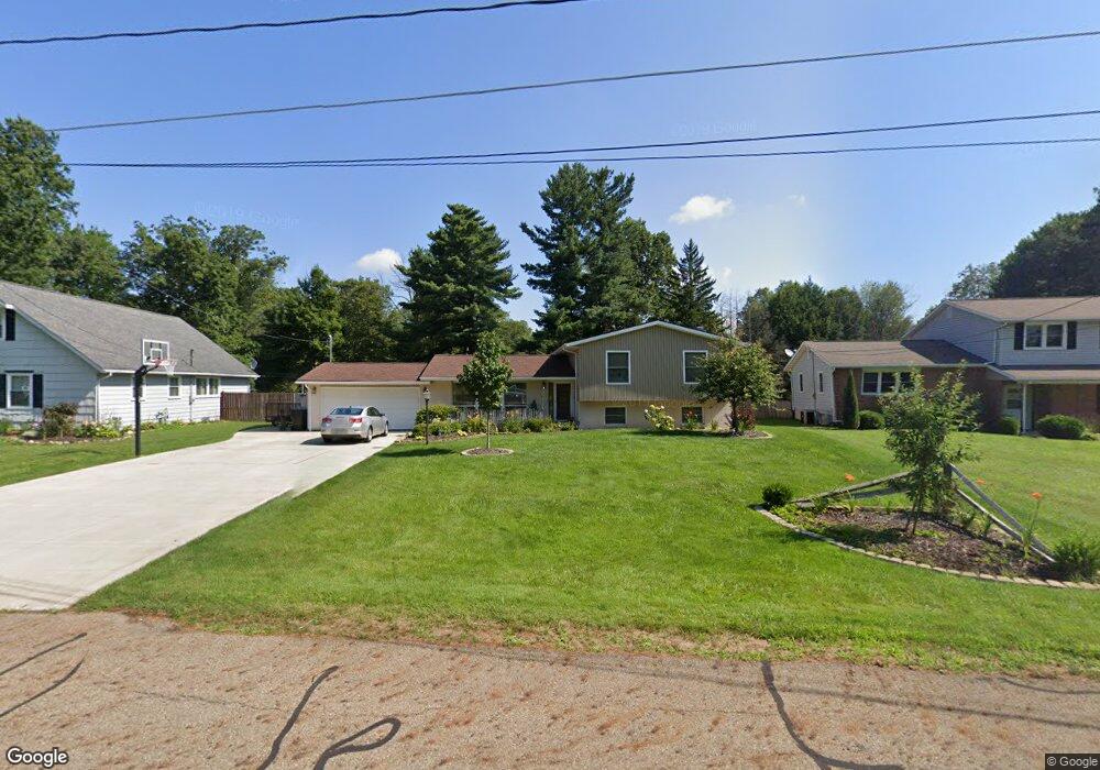
450 Walfield Dr Mansfield, OH 44904
Estimated Value: $234,000 - $257,000
4
Beds
3
Baths
1,536
Sq Ft
$159/Sq Ft
Est. Value
About This Home
This home is located at 450 Walfield Dr, Mansfield, OH 44904 and is currently estimated at $244,256, approximately $159 per square foot. 450 Walfield Dr is a home located in Richland County with nearby schools including Lexington High School, Mansfield Christian School, and Mansfield Seventh-day Adventist School.
Ownership History
Date
Name
Owned For
Owner Type
Purchase Details
Closed on
Apr 7, 2006
Sold by
Keiper David P and Keiper Paula M
Bought by
Baughman Mark A and Baughman Susan C
Current Estimated Value
Home Financials for this Owner
Home Financials are based on the most recent Mortgage that was taken out on this home.
Original Mortgage
$27,200
Outstanding Balance
$23,067
Interest Rate
8.62%
Mortgage Type
Credit Line Revolving
Estimated Equity
$221,189
Purchase Details
Closed on
Jun 1, 1986
Create a Home Valuation Report for This Property
The Home Valuation Report is an in-depth analysis detailing your home's value as well as a comparison with similar homes in the area
Home Values in the Area
Average Home Value in this Area
Purchase History
| Date | Buyer | Sale Price | Title Company |
|---|---|---|---|
| Baughman Mark A | $136,000 | Southern Title | |
| -- | $48,000 | -- |
Source: Public Records
Mortgage History
| Date | Status | Borrower | Loan Amount |
|---|---|---|---|
| Open | Baughman Mark A | $27,200 | |
| Open | Baughman Mark A | $108,800 |
Source: Public Records
Tax History
| Year | Tax Paid | Tax Assessment Tax Assessment Total Assessment is a certain percentage of the fair market value that is determined by local assessors to be the total taxable value of land and additions on the property. | Land | Improvement |
|---|---|---|---|---|
| 2025 | $3,021 | $58,130 | $6,960 | $51,170 |
| 2024 | $3,021 | $58,130 | $6,960 | $51,170 |
| 2023 | $3,088 | $58,130 | $6,960 | $51,170 |
| 2022 | $2,766 | $43,880 | $5,970 | $37,910 |
| 2021 | $2,806 | $43,880 | $5,970 | $37,910 |
| 2020 | $2,663 | $43,880 | $5,970 | $37,910 |
| 2019 | $2,435 | $36,790 | $5,010 | $31,780 |
| 2018 | $2,096 | $36,790 | $5,010 | $31,780 |
| 2017 | $2,073 | $36,790 | $5,010 | $31,780 |
| 2016 | $1,907 | $32,980 | $4,260 | $28,720 |
| 2015 | $1,907 | $32,980 | $4,260 | $28,720 |
| 2014 | $1,839 | $32,980 | $4,260 | $28,720 |
| 2012 | $896 | $34,010 | $4,400 | $29,610 |
Source: Public Records
Map
Nearby Homes
- 1858 Evline Dr
- 1822 Evline Dr
- 633 Princeton Ct
- 615 Bailey Dr
- 635 Karlson Dr
- 1596 Nantucket Dr
- 2226 Camden Ct
- 1759 Rocky Rill Ct
- 763 York St W
- 1702 Middle Bellville Rd
- 872 Red Oak Trail Unit 3
- 213 Brushwood Dr
- 893 Greenfield Dr
- 920 Greenfield Dr
- 0 Lot #23132 Hess Cir
- 0 Lot #23127 Hess Cir
- 0 Lot #23139 Hess Cir
- 0 Lot #23121 Hess Cir
- 0 Lot #23133 Hess Cir
- 1485 Overdale Dr
- 438 Walfield Dr
- 460 Walfield Dr
- 441 Marwood Dr
- 432 Walfield Dr
- 451 Marwood Dr
- 441 Walfield Dr
- 426 Walfield Dr
- 457 Walfield Dr
- 1965 Farmbrook Dr
- 431 Marwood Dr
- 2003 Farmbrook Dr Unit 2205
- 421 Marwood Dr
- 1995 Farmbrook Dr
- 467 Walfield Dr
- 420 Walfield Dr
- 477 Walfield Dr
- 2044 Random Dr
- 1972 Farmbrook Dr
- 430 Marwood Dr
- 2045 Random Dr
Your Personal Tour Guide
Ask me questions while you tour the home.