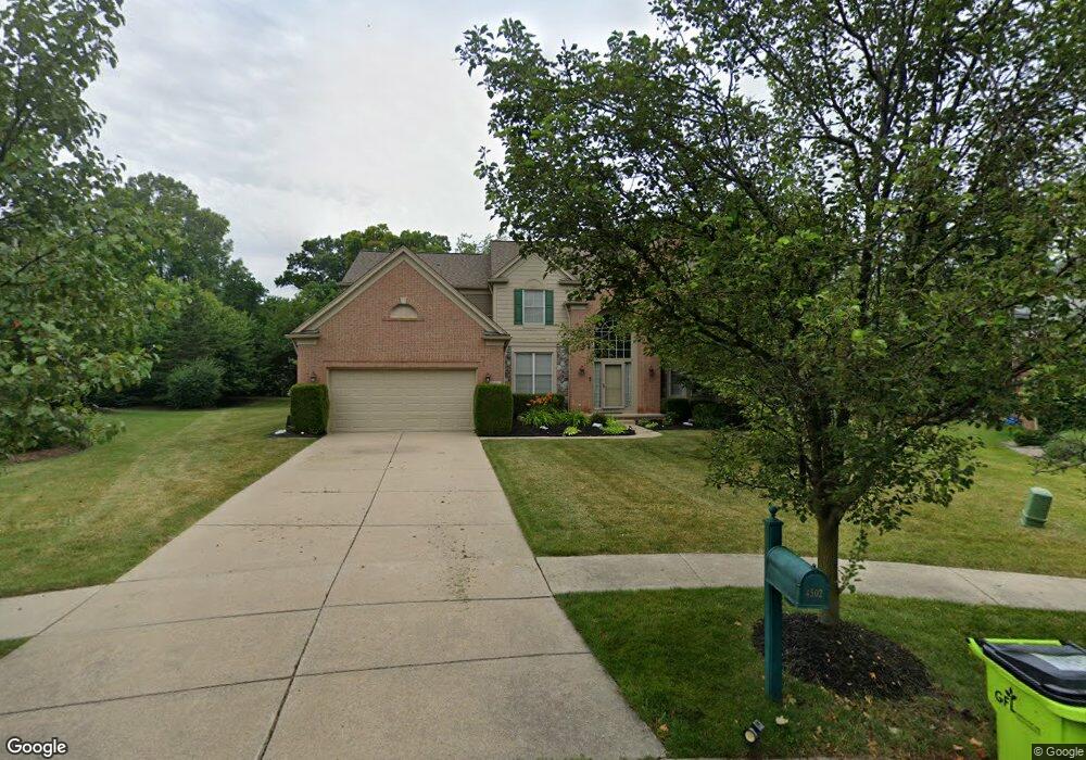
4502 Northridge Ct West Bloomfield, MI 48323
Estimated Value: $563,765 - $695,000
4
Beds
4
Baths
3,056
Sq Ft
$211/Sq Ft
Est. Value
About This Home
This home is located at 4502 Northridge Ct, West Bloomfield, MI 48323 and is currently estimated at $644,441, approximately $210 per square foot. 4502 Northridge Ct is a home located in Oakland County with nearby schools including Walled Lake Central High School, The Susan And Rabbi Harold Loss Ecc, and Brookfield Academy - West Bloomfield.
Ownership History
Date
Name
Owned For
Owner Type
Purchase Details
Closed on
Jul 23, 2018
Sold by
Ogundeji Oladapo
Bought by
Ogundeji Oladapo and Ogundeji Anthonia
Current Estimated Value
Purchase Details
Closed on
Dec 9, 2011
Sold by
Rogers Jacqueline
Bought by
Ogundeji Oladapo
Home Financials for this Owner
Home Financials are based on the most recent Mortgage that was taken out on this home.
Original Mortgage
$263,155
Outstanding Balance
$179,670
Interest Rate
3.97%
Mortgage Type
FHA
Estimated Equity
$464,771
Purchase Details
Closed on
Jul 6, 2005
Sold by
Thrasher Gregory B and Thrasher Victoria L
Bought by
Rogers Jacqueline
Create a Home Valuation Report for This Property
The Home Valuation Report is an in-depth analysis detailing your home's value as well as a comparison with similar homes in the area
Home Values in the Area
Average Home Value in this Area
Purchase History
| Date | Buyer | Sale Price | Title Company |
|---|---|---|---|
| Ogundeji Oladapo | -- | None Available | |
| Ogundeji Oladapo | $270,000 | Title Connect Llc | |
| Rogers Jacqueline | $427,450 | None Available |
Source: Public Records
Mortgage History
| Date | Status | Borrower | Loan Amount |
|---|---|---|---|
| Open | Ogundeji Oladapo | $263,155 |
Source: Public Records
Tax History Compared to Growth
Tax History
| Year | Tax Paid | Tax Assessment Tax Assessment Total Assessment is a certain percentage of the fair market value that is determined by local assessors to be the total taxable value of land and additions on the property. | Land | Improvement |
|---|---|---|---|---|
| 2024 | $3,408 | $226,830 | $0 | $0 |
| 2022 | $3,213 | $210,960 | $20,000 | $190,960 |
| 2021 | $5,290 | $199,770 | $0 | $0 |
| 2020 | $3,175 | $197,450 | $20,000 | $177,450 |
| 2018 | $5,143 | $186,730 | $20,000 | $166,730 |
| 2015 | -- | $163,160 | $0 | $0 |
| 2014 | -- | $148,650 | $0 | $0 |
| 2011 | -- | $121,240 | $0 | $0 |
Source: Public Records
Map
Nearby Homes
- 6980 Hambro St
- 4335 Crestdale Ave
- 4442 Borland St
- 4245 Bunker Ave
- 4212 Greendale Ave
- 7337 Richardson Rd
- 7359 Woodlore Dr
- 7381 Crestmore St
- 4540 Rolling Pine Ct
- 6978 Colony Dr
- 4066 Green Lake Rd
- 0000 Langtoft
- 6675 Langtoft St
- 3991 Fieldview Ave
- 7065 Deerwood Trail Unit 27
- 3965 Carrick Ave
- 6903 Dandison Blvd
- 3950 Bradmore Ave
- 7555 Windgate Cir
- 6768 Buckland Ave
- 4514 Northridge Ct
- 4509 Northridge Ct Unit 14
- 4526 Northridge Ct
- 4475 Cedar Ave Unit Bldg-Unit
- 4475 Cedar Ave
- 7020 Oakley Park
- 4505 Middledale Rd S Unit 1
- 7010 Oakley Park
- 7080 Oakley Park
- 4538 Northridge Ct
- 4533 Northridge Ct Unit 15
- 4517 Middledale Rd S
- 4465 Cedar Ave
- 7100 Oakley Park
- 4505 Green Lake Rd
- 4460 Green Lake Rd
- 4550 Northridge Ct Unit 9
- 4545 Northridge Ct
- 4529 Middledale Rd S
- 4521 Green Lake Rd