Estimated payment $2,975/month
Highlights
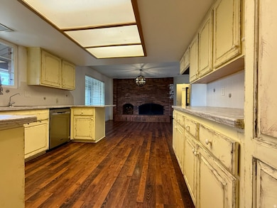
- Second Kitchen
- Fruit Trees
- Community Pool
- RV Parking in Community
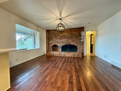
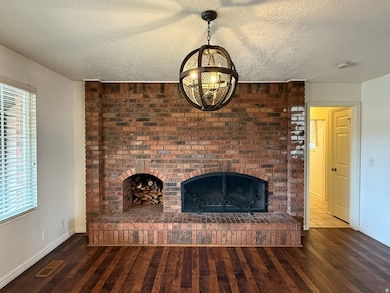
- 2 Fireplaces
- Cul-De-Sac
About This Home
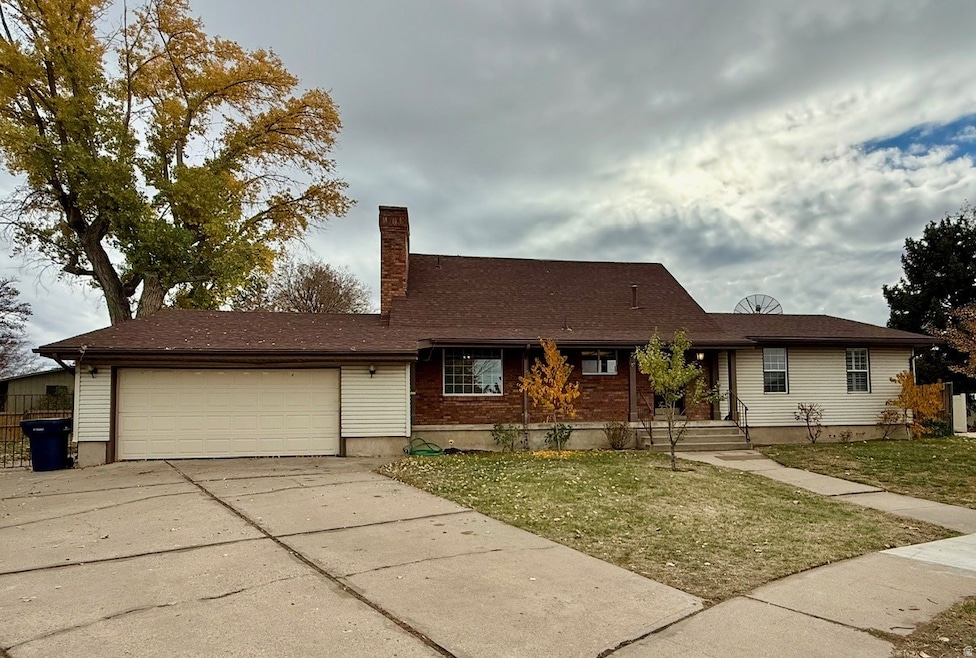
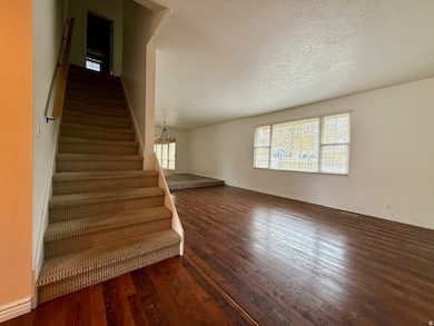
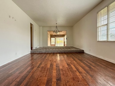
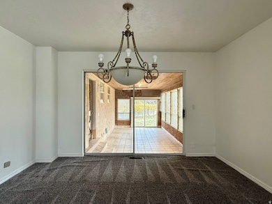
(Sold As-Is Will Not Go VA/FHA). Welcome to this expansive 6-bedroom, 4.5-bathroom home offering over 4,000 sq. ft. of living space on a lovely .28-acre lot. Nestled at the end of a peaceful cul-de-sac, this home combines, comfort, and functionality - perfect for a large family or multi-generational living. The main level offers bright, open living spaces and a charming sunroom, ideal for relaxing and enjoying the outdoors year-round. The finished basement features a separate entrance, making it perfect for an in-law suite, guest quarters, or potential rental space. Additional highlights include ample storage in both the basement and second floor, with a temperature-controlled storage area. Step outside to the large, private backyard, garden space, and plenty of room for outdoor entertaining. This is a rare opportunity to own such a home with endless possibilities - sold As-Is and ready for your finishing touches!
Listing Agent
Braden Shupe
RE/MAX Associates License #5485399 Listed on: 11/07/2025
Home Details
Home Type
- Single Family
Est. Annual Taxes
- $3,485
Year Built
- Built in 1975
Lot Details
- 0.28 Acre Lot
- Cul-De-Sac
- Partially Fenced Property
- Fruit Trees
- Mature Trees
- Property is zoned Single-Family
HOA Fees
- $50 Monthly HOA Fees
Parking
- 2 Car Attached Garage
- 4 Open Parking Spaces
Home Design
- Brick Exterior Construction
Interior Spaces
- 4,057 Sq Ft Home
- 3-Story Property
- 2 Fireplaces
- Gas Log Fireplace
- Electric Dryer Hookup
Kitchen
- Second Kitchen
- Free-Standing Range
Flooring
- Carpet
- Vinyl
Bedrooms and Bathrooms
- 6 Bedrooms | 3 Main Level Bedrooms
- In-Law or Guest Suite
Basement
- Basement Fills Entire Space Under The House
- Exterior Basement Entry
Schools
- North Park Elementary School
- Sand Ridge Middle School
- Roy High School
Utilities
- Forced Air Heating and Cooling System
- Natural Gas Connected
Additional Features
- Reclaimed Water Irrigation System
- Open Patio
Listing and Financial Details
- Assessor Parcel Number 08-129-0007
Community Details
Overview
- RV Parking in Community
Amenities
- Picnic Area
Recreation
- Community Playground
- Community Pool
Map
Home Values in the Area
Average Home Value in this Area
Tax History
| Year | Tax Paid | Tax Assessment Tax Assessment Total Assessment is a certain percentage of the fair market value that is determined by local assessors to be the total taxable value of land and additions on the property. | Land | Improvement |
|---|---|---|---|---|
| 2025 | $3,485 | $566,887 | $160,903 | $405,984 |
| 2024 | $3,400 | $557,000 | $160,918 | $396,082 |
| 2023 | $3,223 | $290,401 | $84,805 | $205,596 |
| 2022 | $3,093 | $284,901 | $67,942 | $216,959 |
| 2021 | $2,664 | $405,000 | $87,613 | $317,387 |
| 2020 | $2,429 | $338,000 | $87,613 | $250,387 |
| 2019 | $2,441 | $321,000 | $52,047 | $268,953 |
| 2018 | $2,333 | $289,000 | $47,059 | $241,941 |
| 2017 | $2,181 | $253,000 | $47,059 | $205,941 |
| 2016 | $1,951 | $120,837 | $25,392 | $95,445 |
| 2015 | $1,902 | $121,292 | $22,645 | $98,647 |
| 2014 | $1,839 | $115,670 | $22,645 | $93,025 |
Property History
| Date | Event | Price | List to Sale | Price per Sq Ft |
|---|---|---|---|---|
| 11/07/2025 11/07/25 | For Sale | $500,000 | -- | $123 / Sq Ft |
Purchase History
| Date | Type | Sale Price | Title Company |
|---|---|---|---|
| Warranty Deed | -- | First American Title | |
| Warranty Deed | -- | U S Title Of Utah Ogden | |
| Interfamily Deed Transfer | -- | -- | |
| Warranty Deed | -- | Bonneville Title |
Mortgage History
| Date | Status | Loan Amount | Loan Type |
|---|---|---|---|
| Open | $263,000 | New Conventional | |
| Previous Owner | $205,000 | Purchase Money Mortgage |
Source: UtahRealEstate.com
MLS Number: 2121894
APN: 08-129-0007
Disclaimer: Certain information contained herein is derived from information provided by parties other than Homes.com. All information provided is deemed reliable, but is not guaranteed to be accurate and should be independently verified.
![]() IDX information is provided exclusively for consumers’ personal, non-commercial use, that it may not be used for any purpose other than to identify prospective properties consumers may be interested in purchasing, and that the data is deemed reliable but is not guaranteed accurate by the MLS. Licensor is only providing the MLS Content and not other sources of data provided in the Product.
IDX information is provided exclusively for consumers’ personal, non-commercial use, that it may not be used for any purpose other than to identify prospective properties consumers may be interested in purchasing, and that the data is deemed reliable but is not guaranteed accurate by the MLS. Licensor is only providing the MLS Content and not other sources of data provided in the Product.
Based on information from the Wasatch Front Regional Multiple Listing Service, Inc.. All data, including all measurements and calculations of area, is obtained from various sources and has not been, and will not be, verified by broker or the MLS. All information should be independently reviewed and verified for accuracy. Properties may or may not be listed by the office/agent presenting the information.
- 4552 S 1675 W
- 4593 Promenade Dr
- 1681 W 4450 S
- 1766 W 4575 S
- 4438 S 1700 W
- 4602 Hathaway Dr
- 1825 W 4500 S Unit 101
- 4536 S 1900 W Unit 12
- 1825 W 4400 S
- 4642 S 1900 W Unit 41
- 4475 S 1975 W
- 2038 W 4600 S
- 1789 W 5000 S
- 5006 S 1800 W
- 1765 W 5000 S
- 4505 S 2075 W
- 2082 W 4450 S
- 1758 W 5025 S
- 2067 W 4750 S
- 1789 W 5050 S
- 1801 W 4650 S
- 4499 S 1930 W
- 2225 W 4350 S
- 5000 S 1900 W
- 1551 W Riverdale Rd
- 4177 S 1000 W
- 2619 W 4650 S
- 2575 W 4800 S
- 4389 S Locomotive Dr
- 4621 S W Pk Dr
- 4345 S 700 W
- 2405 Hinckley Dr
- 2196 W 5600 S Unit A
- 5239 S 2700 W
- 3024 W 4450 S
- 557 Laker Way
- 4535 S Ridgeline Dr
- 2112 W 3300 S
- 4189 S 300 W
- 4860 S 250 W Unit 2 Bed 1 Bath