
Seller's Agent in 2025
Jessica Longo
KW Professionals
(773) 569-9425
20 in this area
93 Total Sales
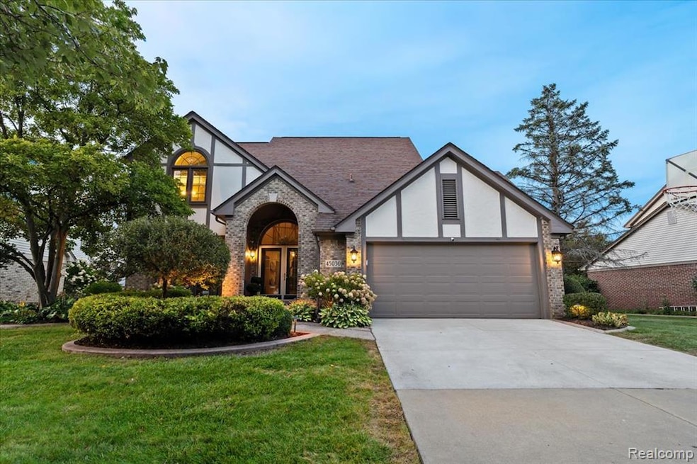
Welcome to this beautifully updated home in the highly sought-after Glengarry Village neighborhood of Canton Twp. Blending modern upgrades with timeless comfort, this home showcases an updated kitchen (2016) with Corian counters, double ovens, a prep sink, and soft-close cabinetry. A dry bar with matching Corian counters ties seamlessly into the dining area, creating the perfect setup for entertaining. Step outside to your private outdoor oasis, complete with a Trex deck, stamped concrete patio, fire pit, and hot tub (2017)—ideal for year-round enjoyment. The finished basement with a full bath offers flexible space for guests, recreation, or a home office. Upstairs, the spacious primary suite features two walk-in closets and a versatile loft currently used as an office/craft room, which could easily be enclosed to create a 4th bedroom. Recent updates include Wallside Windows with a transferable 35-year guarantee, Hardie Board siding, professional landscaping with exterior lighting, a new hot water heater, and a Genie garage door opener. This home is also EV-ready with two charging stations (GM Energy 11.2 KW and ChargePoint). Pride of ownership shines throughout this move-in-ready home, located close to top-rated schools, parks, dining, the library, and shopping. Don’t miss your chance—join us at the open house on Saturday!
Last Agent to Sell the Property
KW Professionals License #6501410420 Listed on: 09/27/2025
| Date | Type | Sale Price | Title Company |
|---|---|---|---|
| Warranty Deed | $580,000 | None Listed On Document | |
| Corporate Deed | $219,000 | Fidelity National Title | |
| Warranty Deed | $219,000 | Fidelity National Title |
| Date | Status | Loan Amount | Loan Type |
|---|---|---|---|
| Previous Owner | $216,090 | FHA |
| Date | Event | Price | List to Sale | Price per Sq Ft |
|---|---|---|---|---|
| 11/03/2025 11/03/25 | Sold | $580,000 | +5.5% | $244 / Sq Ft |
| 09/28/2025 09/28/25 | Pending | -- | -- | -- |
| 09/27/2025 09/27/25 | For Sale | $550,000 | -- | $232 / Sq Ft |
| Year | Tax Paid | Tax Assessment Tax Assessment Total Assessment is a certain percentage of the fair market value that is determined by local assessors to be the total taxable value of land and additions on the property. | Land | Improvement |
|---|---|---|---|---|
| 2025 | $3,120 | $235,300 | $0 | $0 |
| 2024 | $3,032 | $217,500 | $0 | $0 |
| 2023 | $2,890 | $196,400 | $0 | $0 |
| 2022 | $6,267 | $175,000 | $0 | $0 |
| 2021 | $6,081 | $170,500 | $0 | $0 |
| 2020 | $6,006 | $165,300 | $0 | $0 |
| 2019 | $5,897 | $160,570 | $0 | $0 |
| 2018 | $2,456 | $154,600 | $0 | $0 |
| 2017 | $5,731 | $145,300 | $0 | $0 |
| 2016 | $5,149 | $141,300 | $0 | $0 |
| 2015 | $12,960 | $137,290 | $0 | $0 |
| 2013 | $12,628 | $131,840 | $0 | $0 |
| 2010 | -- | $118,710 | $54,052 | $64,658 |
Seller's Agent in 2025
Jessica Longo
KW Professionals
(773) 569-9425
20 in this area
93 Total Sales
Buyer's Agent in 2025
Sarah Maiga
Maiga Homes, LLC
(248) 821-6909
25 in this area
138 Total Sales
Source: Realcomp
MLS Number: 20251039769
APN: 71-086-02-0108-000
Disclaimer: Certain information contained herein is derived from information provided by parties other than Homes.com. All information provided is deemed reliable, but is not guaranteed to be accurate and should be independently verified.
![]() IDX provided courtesy of Realcomp II Ltd. via Ten-X and MLS
IDX provided courtesy of Realcomp II Ltd. via Ten-X and MLS
Copyright 2026 Realcomp II Ltd. Shareholders
IDX information is provided exclusively for consumers' personal, noncommercial use and may not be used for any purpose other than to identify prospective properties consumers may be interested in purchasing. The accuracy of all information, regardless of source, is not guaranteed or warranted. All information should be independently verified.
Listing Information presented by local MLS brokerage: Ten-X, local REALTOR®- Arlene Richardson - (888)-952-6393
Ask me questions while you tour the home.