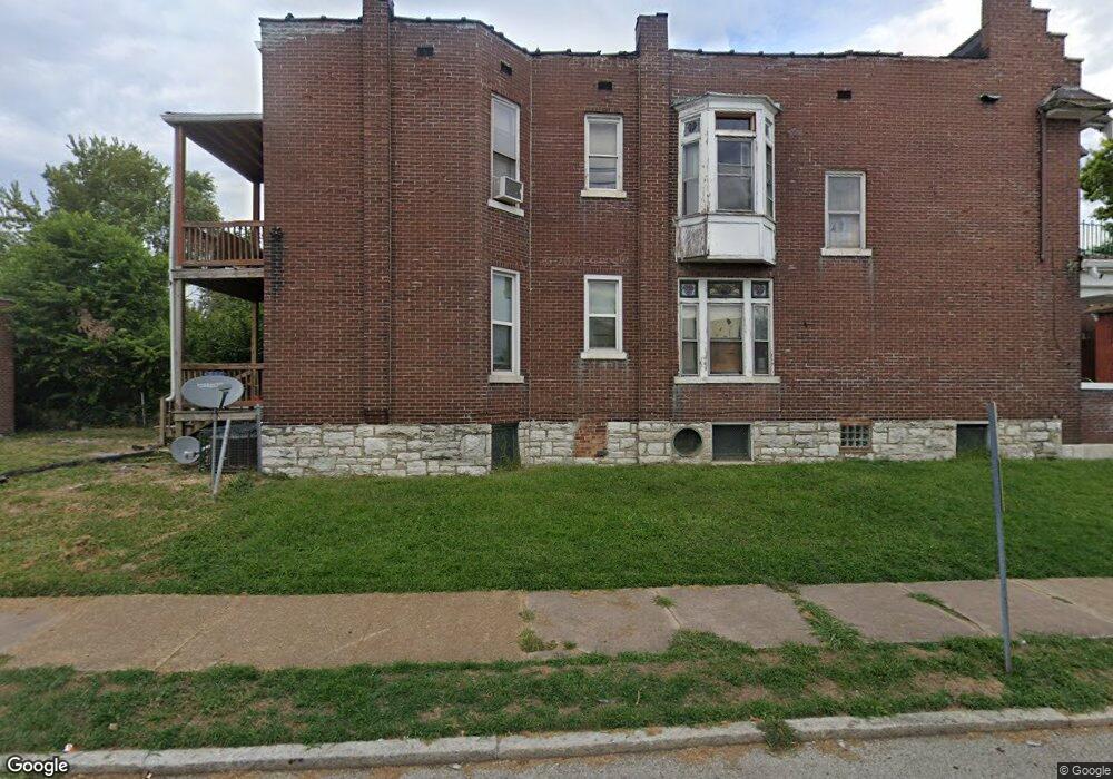
4505 Adelaide Ave Saint Louis, MO 63115
O'Fallon NeighborhoodEstimated Value: $41,432 - $76,000
Studio
2
Baths
2,756
Sq Ft
$24/Sq Ft
Est. Value
About This Home
This home is located at 4505 Adelaide Ave, Saint Louis, MO 63115 and is currently estimated at $65,608, approximately $23 per square foot. 4505 Adelaide Ave is a home located in St. Louis City with nearby schools including Hickey Elementary School, Yeatman-Liddell Middle School, and Vashon High School.
Ownership History
Date
Name
Owned For
Owner Type
Purchase Details
Closed on
Oct 4, 2021
Sold by
Stevenson Shatari
Bought by
Kemp Antonio
Current Estimated Value
Purchase Details
Closed on
Jan 17, 2014
Sold by
Kemp Antonio L
Bought by
Stevenson Sha Tari
Purchase Details
Closed on
Dec 12, 2008
Sold by
Secretary Of Housing & Urban Development
Bought by
Kemp Antonio
Purchase Details
Closed on
Apr 25, 2008
Sold by
Midfirst Bank
Bought by
Hud
Purchase Details
Closed on
Feb 19, 2008
Sold by
The Estate Of Frances Kelly
Bought by
Midfirst Bank
Create a Home Valuation Report for This Property
The Home Valuation Report is an in-depth analysis detailing your home's value as well as a comparison with similar homes in the area
Home Values in the Area
Average Home Value in this Area
Purchase History
| Date | Buyer | Sale Price | Title Company |
|---|---|---|---|
| Kemp Antonio | $300 | None Available | |
| Stevenson Sha Tari | -- | None Available | |
| Kemp Antonio | -- | First American Title Ins Co | |
| Hud | -- | None Available | |
| Midfirst Bank | $29,395 | None Available |
Source: Public Records
Tax History
| Year | Tax Paid | Tax Assessment Tax Assessment Total Assessment is a certain percentage of the fair market value that is determined by local assessors to be the total taxable value of land and additions on the property. | Land | Improvement |
|---|---|---|---|---|
| 2025 | $216 | $2,300 | $530 | $1,770 |
| 2024 | $206 | $2,240 | $530 | $1,710 |
| 2023 | $206 | $2,240 | $530 | $1,710 |
| 2022 | $210 | $2,200 | $530 | $1,670 |
| 2021 | $210 | $2,200 | $530 | $1,670 |
| 2020 | $208 | $2,200 | $530 | $1,670 |
| 2019 | $208 | $2,200 | $530 | $1,670 |
| 2018 | $207 | $2,130 | $530 | $1,600 |
| 2017 | $204 | $2,130 | $530 | $1,600 |
| 2016 | $355 | $3,900 | $1,010 | $2,890 |
| 2015 | $324 | $3,900 | $1,010 | $2,890 |
| 2014 | $358 | $3,900 | $1,010 | $2,890 |
| 2013 | -- | $4,350 | $1,010 | $3,340 |
Source: Public Records
Map
Nearby Homes
- 4523 Adelaide Ave
- 4267 Fair Ave
- 4501 Mary Ave
- 4210 E Carter Ave
- 4142 E Penrose St
- 3931 Lee Ave
- 4261 Red Bud Ave
- 2042 E Adelaide Ave
- 4450 Holly Ave
- 3937 Lee Ave
- 4223 Athlone Ave
- 4535 Holly Ave
- 4210 Holly Ave
- 4537 Clarence Ave
- 4402 Clarence Ave
- 4555 Clarence Ave
- 3901 Sherman Place
- 4608 Pope Ave
- 1912 E Adelaide Ave
- 5225 Conde St
- 4509 Adelaide Ave
- 4503 Adelaide Ave
- 4511 Adelaide Ave
- 4515 Adelaide Ave
- 4517 Adelaide Ave
- 4157 Rosalie St
- 4506 Fair Ave
- 4521 Adelaide Ave
- 4510 Fair Ave
- 4143 E Carter Ave
- 4512 Fair Ave
- 4147 W Carter Ave
- 4514 Fair Ave
- 4502 Fair Ave
- 4410 Fair Ave
- 4506 Adelaide Ave
- 4502 Adelaide Ave
- 4508 Adelaide Ave
- 4408 Fair Ave
- 4500 Adelaide Ave
Your Personal Tour Guide
Ask me questions while you tour the home.