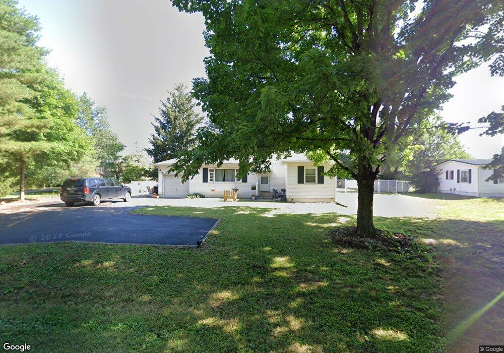
451 Anderson Station Rd Chillicothe, OH 45601
Estimated Value: $146,000 - $253,000
3
Beds
1
Bath
1,080
Sq Ft
$183/Sq Ft
Est. Value
About This Home
This home is located at 451 Anderson Station Rd, Chillicothe, OH 45601 and is currently estimated at $197,970, approximately $183 per square foot. 451 Anderson Station Rd is a home located in Ross County with nearby schools including Unioto Elementary School, Unioto Middle School, and Unioto High School.
Ownership History
Date
Name
Owned For
Owner Type
Purchase Details
Closed on
Feb 15, 2022
Sold by
Hagerty Llc
Bought by
Liggins Larry A
Current Estimated Value
Home Financials for this Owner
Home Financials are based on the most recent Mortgage that was taken out on this home.
Original Mortgage
$96,000
Outstanding Balance
$89,143
Interest Rate
3.55%
Mortgage Type
Seller Take Back
Estimated Equity
$108,827
Purchase Details
Closed on
Apr 13, 2009
Sold by
Secretary Of Housing & Urban Development
Bought by
Hagerty Llc
Purchase Details
Closed on
Dec 16, 2008
Sold by
Chase Home Finance Llc
Bought by
Secretary Of Housing & Urban Development
Purchase Details
Closed on
Dec 8, 2008
Sold by
Odel Tammy
Bought by
Chase Home Finance Llc
Create a Home Valuation Report for This Property
The Home Valuation Report is an in-depth analysis detailing your home's value as well as a comparison with similar homes in the area
Home Values in the Area
Average Home Value in this Area
Purchase History
| Date | Buyer | Sale Price | Title Company |
|---|---|---|---|
| Liggins Larry A | $96,000 | Bugg Clifford N | |
| Hagerty Llc | $39,000 | Lakeside Title & Escrow | |
| Secretary Of Housing & Urban Development | -- | None Available | |
| Chase Home Finance Llc | $40,000 | None Available |
Source: Public Records
Mortgage History
| Date | Status | Borrower | Loan Amount |
|---|---|---|---|
| Open | Liggins Larry A | $96,000 |
Source: Public Records
Tax History Compared to Growth
Tax History
| Year | Tax Paid | Tax Assessment Tax Assessment Total Assessment is a certain percentage of the fair market value that is determined by local assessors to be the total taxable value of land and additions on the property. | Land | Improvement |
|---|---|---|---|---|
| 2024 | $1,079 | $29,080 | $6,070 | $23,010 |
| 2023 | $1,028 | $29,080 | $6,070 | $23,010 |
| 2022 | $1,103 | $29,080 | $6,070 | $23,010 |
| 2021 | $920 | $23,840 | $5,060 | $18,780 |
| 2020 | $925 | $23,840 | $5,060 | $18,780 |
| 2019 | $925 | $23,840 | $5,060 | $18,780 |
| 2018 | $914 | $23,090 | $4,170 | $18,920 |
| 2017 | $915 | $23,090 | $4,170 | $18,920 |
| 2016 | $893 | $23,090 | $4,170 | $18,920 |
| 2015 | $881 | $22,540 | $4,170 | $18,370 |
| 2014 | $861 | $22,540 | $4,170 | $18,370 |
| 2013 | $865 | $22,540 | $4,170 | $18,370 |
Source: Public Records
Map
Nearby Homes
- 54 Moccasin Dr
- 313 Goodale Dr
- 365 Golfview Dr
- 102 Franklin Cir
- 559 Golfview Dr
- 11303 County Road 550
- 435 Mount Carmel Rd
- 10217 County Road 550
- 18 Sarah Ct
- 2083 Anderson Station Rd
- 420 Steiner Rd
- 12690 Pleasant Valley Rd
- 1036 Clinton Rd
- 320 Summerhill Dr
- 2719 Sulphur Lick Rd
- 13223 Pleasant Valley Rd
- 265 Brookside Dr
- 2153 Egypt Pike
- 88 Fruit Hill Dr
- 25 Woodland Way
- 471 Anderson Station Rd
- 491 Anderson Station Rd
- 403 Anderson Station Rd
- 509 Anderson Station Rd
- 402 Anderson Station Rd
- 527 Anderson Station Rd
- 345 Anderson Station Rd
- 349 Anderson Station Rd
- 344 Anderson Station Rd
- 194 Flint Dr
- 552 Anderson Station Rd
- 340 Anderson Station Rd
- 321 Anderson Station Rd
- 555 Anderson Station Rd
- 320 Anderson Station Rd
- 164 Flint Dr
- 593 Anderson Station Rd
- 226 Flint Dr
- 590 Anderson Station Rd
- 342 Anderson Station Rd