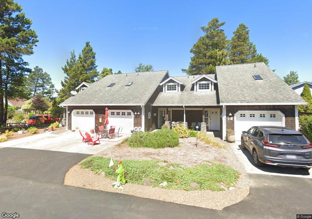
451 Dorcas Ln Unit 2 Manzanita, OR 97130
Estimated Value: $595,681 - $733,000
3
Beds
2
Baths
1,490
Sq Ft
$449/Sq Ft
Est. Value
About This Home
This home is located at 451 Dorcas Ln Unit 2, Manzanita, OR 97130 and is currently estimated at $668,670, approximately $448 per square foot. 451 Dorcas Ln Unit 2 is a home located in Tillamook County with nearby schools including Nehalem Elementary School, Garibaldi Elementary School, and Neah-Kah-Nie Middle School.
Ownership History
Date
Name
Owned For
Owner Type
Purchase Details
Closed on
Nov 16, 2007
Sold by
Burroughs Gary S and Burroughs Corrine G
Bought by
Burroughs Corrine G
Current Estimated Value
Purchase Details
Closed on
Nov 18, 2005
Sold by
Hovis Watson B and Hovis Maryn N
Bought by
Burroughs Gary S and Burroughs Corrine G
Home Financials for this Owner
Home Financials are based on the most recent Mortgage that was taken out on this home.
Original Mortgage
$335,000
Interest Rate
5.93%
Mortgage Type
Unknown
Create a Home Valuation Report for This Property
The Home Valuation Report is an in-depth analysis detailing your home's value as well as a comparison with similar homes in the area
Home Values in the Area
Average Home Value in this Area
Purchase History
| Date | Buyer | Sale Price | Title Company |
|---|---|---|---|
| Burroughs Corrine G | -- | None Available | |
| Burroughs Gary S | $335,000 | First American |
Source: Public Records
Mortgage History
| Date | Status | Borrower | Loan Amount |
|---|---|---|---|
| Closed | Burroughs Gary S | $335,000 |
Source: Public Records
Tax History Compared to Growth
Tax History
| Year | Tax Paid | Tax Assessment Tax Assessment Total Assessment is a certain percentage of the fair market value that is determined by local assessors to be the total taxable value of land and additions on the property. | Land | Improvement |
|---|---|---|---|---|
| 2024 | $3,786 | $320,630 | -- | $320,630 |
| 2023 | $3,753 | $311,300 | $0 | $311,300 |
| 2022 | $3,529 | $302,240 | $0 | $302,240 |
| 2021 | $3,424 | $293,440 | $0 | $293,440 |
| 2020 | $3,288 | $284,900 | $0 | $284,900 |
| 2019 | $3,196 | $276,610 | $0 | $276,610 |
| 2018 | $3,113 | $268,560 | $0 | $268,560 |
| 2017 | $3,025 | $260,740 | $0 | $260,740 |
| 2016 | $2,938 | $253,150 | $0 | $253,150 |
| 2015 | $2,884 | $245,780 | $0 | $245,780 |
| 2014 | $2,836 | $238,630 | $0 | $238,630 |
| 2013 | -- | $231,680 | $0 | $231,680 |
Source: Public Records
Map
Nearby Homes
- 0 Laneda at 4th Place Unit 24456685
- 0 Laneda at 4th Place Unit 24-691
- 368 4th Place
- 370 4th Place S
- 0 Pine Ridge Dr Unit 24394081
- 0 Pine Ridge Dr Unit 141 24100339
- 0 Pine Ridge Dr Unit 147 24535382
- 0 Pine Ridge Dr Unit 71 24554922
- 360 Jackson Way
- 559 Ridge Dr
- 511 1st St
- 558 Sea View Dr
- 388 Ridge Ct
- 0 Seaview Dr Unit 25-989
- 0 Seaview Dr Unit 53
- 558 Seaview Dr
- 476 Seaview Dr Unit 62
- 796 Madrona St
- 456 Seaview Dr
- 486 Meadows Dr Unit 81
- 449 Dorcas Ln
- 449 Dorcas Ln Unit ONE
- 164 S Fourth Place
- 453 Dorcas Ln Unit 3
- 165 4th Place S
- 165 S Fourth Place
- 447 Dorcas Ln
- 472 Laneda Ave
- 444 Dorcas Ln
- TL 3902 Laneda Ave
- 446 Dorcas Ln
- 430 Laneda Ave
- 448 Dorcas Ln
- 428 Dorcas Ln
- 457 Laneda Ave
- 447 Laneda 1weuouqh8xax
- 447 Laneda Ave
- 410 Laneda Ave
- 450 Dorcas Ln
- 258 4th Place S