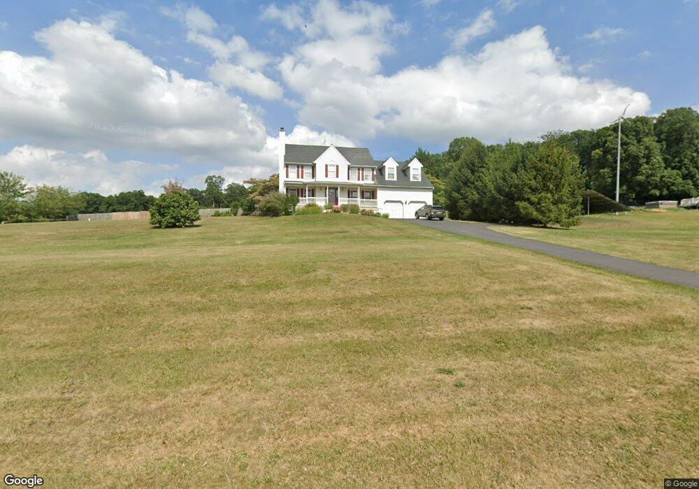
451 Hand Ct Hampstead, MD 21074
Estimated Value: $507,723 - $620,000
Studio
3
Baths
2,794
Sq Ft
$205/Sq Ft
Est. Value
About This Home
This home is located at 451 Hand Ct, Hampstead, MD 21074 and is currently estimated at $572,431, approximately $204 per square foot. 451 Hand Ct is a home located in Carroll County with nearby schools including Hampstead Elementary School, Shiloh Middle School, and Manchester Valley High School.
Ownership History
Date
Name
Owned For
Owner Type
Purchase Details
Closed on
Feb 15, 1994
Sold by
Appletree Dev Co Llc
Bought by
Lowder William K
Current Estimated Value
Home Financials for this Owner
Home Financials are based on the most recent Mortgage that was taken out on this home.
Original Mortgage
$203,000
Interest Rate
7.08%
Purchase Details
Closed on
Mar 25, 1993
Sold by
Hand Iris B
Bought by
Appletree Development Company
Create a Home Valuation Report for This Property
The Home Valuation Report is an in-depth analysis detailing your home's value as well as a comparison with similar homes in the area
Home Values in the Area
Average Home Value in this Area
Purchase History
| Date | Buyer | Sale Price | Title Company |
|---|---|---|---|
| Lowder William K | $231,600 | -- | |
| Appletree Development Company | $315,000 | -- |
Source: Public Records
Mortgage History
| Date | Status | Borrower | Loan Amount |
|---|---|---|---|
| Closed | Lowder William K | $203,000 |
Source: Public Records
Tax History
| Year | Tax Paid | Tax Assessment Tax Assessment Total Assessment is a certain percentage of the fair market value that is determined by local assessors to be the total taxable value of land and additions on the property. | Land | Improvement |
|---|---|---|---|---|
| 2025 | $4,629 | $421,100 | $140,000 | $281,100 |
| 2024 | $4,408 | $397,800 | $0 | $0 |
| 2023 | $4,196 | $374,500 | $0 | $0 |
| 2022 | $3,993 | $351,200 | $140,000 | $211,200 |
| 2021 | $8,145 | $349,767 | $0 | $0 |
| 2020 | $3,996 | $348,333 | $0 | $0 |
| 2019 | $3,980 | $346,900 | $140,000 | $206,900 |
| 2018 | $3,945 | $346,900 | $140,000 | $206,900 |
| 2017 | $3,945 | $346,900 | $0 | $0 |
| 2016 | -- | $350,600 | $0 | $0 |
| 2015 | -- | $350,167 | $0 | $0 |
| 2014 | -- | $349,733 | $0 | $0 |
Source: Public Records
Map
Nearby Homes
- 0 Hoffman Mill Rd
- 0 Houcksville Rd Unit MDCR2032106
- 820 Wembley Dr Unit 2C
- 820 Wembley Dr Unit 2A
- 820 Wembley Dr Unit 2B
- 820 Wembley Dr Unit 3D
- 820 Wembley Dr Unit 2D
- 820 Wembley Dr Unit 1D
- 820 Wembley Dr Unit 1A
- 820 Wembley Dr Unit 3B
- 820 Wembley Dr Unit 3A
- 820 Wembley Dr Unit 1B
- 820 Wembley Dr Unit 3C
- 820 Wembley Dr Unit 1C
- 3230 Coon Club Rd
- 0 Coon Club
- 105 S Houcksville Rd
- 3860 Normandy Dr Unit 3D
- 3850 Normandy Dr Unit 3A
- 3870 Normandy Dr Unit 2C
- 445 Hand Ct
- 455 Hand Ct
- 505 German Dr
- 3550 Shane Dr
- 3535 Hoffman Mill Rd
- 446 Hand Ct
- 515 German Dr
- 437 Hand Ct
- 459 Hand Ct
- 438 Hand Ct
- 14 Jennica Dr
- 3525 Hoffman Mill Rd
- 3495 Jennica Dr
- 433 Hand Ct
- OC2 Highgate Dr Unit TULARE
- OC2 Highgate Dr Unit REGINA
- OC2 Highgate Dr Unit RAINIER
- 3541 Hoffman Mill Rd
- LOT 2 Hoffman Mill Rd Unit BENTON
- 500 German Dr
Your Personal Tour Guide
Ask me questions while you tour the home.