Estimated Value: $190,000 - $213,000
3
Beds
1
Bath
948
Sq Ft
$215/Sq Ft
Est. Value
About This Home
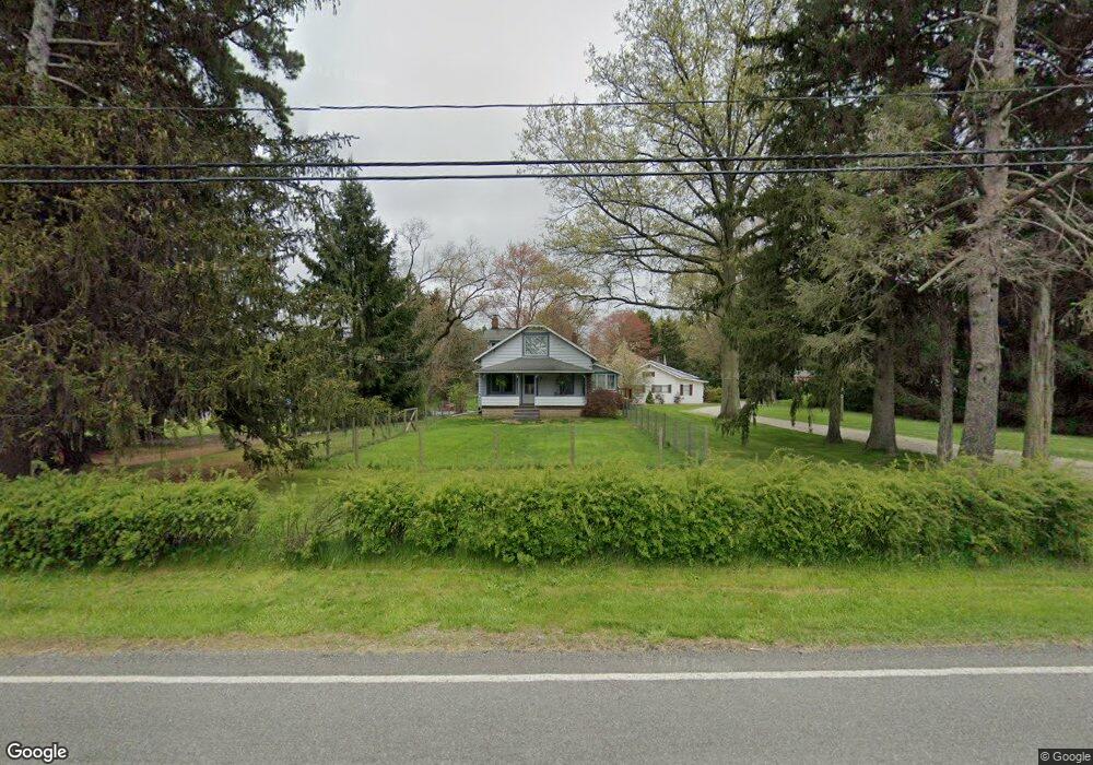
This home is located at 451 Howe Rd, Kent, OH 44240 and is currently estimated at $203,626, approximately $214 per square foot. 451 Howe Rd is a home located in Portage County with nearby schools including Brimfield Elementary School, Field Middle School, and Field High School.
Ownership History
Date
Name
Owned For
Owner Type
Purchase Details
Closed on
Aug 6, 2013
Sold by
Atha Faye
Bought by
Atha Faye and Atha William
Current Estimated Value
Home Financials for this Owner
Home Financials are based on the most recent Mortgage that was taken out on this home.
Original Mortgage
$84,245
Outstanding Balance
$61,486
Interest Rate
4.39%
Mortgage Type
New Conventional
Estimated Equity
$142,140
Purchase Details
Closed on
Jun 2, 2006
Sold by
Callahan Douglas and Callahan Faye
Bought by
Atha Faye
Purchase Details
Closed on
Nov 30, 2000
Sold by
Kelly Enid V
Bought by
Callahan Douglas and Callahan Faye
Home Financials for this Owner
Home Financials are based on the most recent Mortgage that was taken out on this home.
Original Mortgage
$93,500
Interest Rate
7.86%
Mortgage Type
Seller Take Back
Purchase Details
Closed on
Feb 11, 1991
Bought by
Kelly Enid
Create a Home Valuation Report for This Property
The Home Valuation Report is an in-depth analysis detailing your home's value as well as a comparison with similar homes in the area
Home Values in the Area
Average Home Value in this Area
Purchase History
| Date | Buyer | Sale Price | Title Company |
|---|---|---|---|
| Atha Faye | -- | None Available | |
| Atha Faye | -- | Clear Trust Title | |
| Callahan Douglas | $94,000 | Ohio Title | |
| Kelly Enid | -- | -- |
Source: Public Records
Mortgage History
| Date | Status | Borrower | Loan Amount |
|---|---|---|---|
| Open | Atha Faye | $84,245 | |
| Previous Owner | Callahan Douglas | $93,500 |
Source: Public Records
Tax History
| Year | Tax Paid | Tax Assessment Tax Assessment Total Assessment is a certain percentage of the fair market value that is determined by local assessors to be the total taxable value of land and additions on the property. | Land | Improvement |
|---|---|---|---|---|
| 2025 | $2,717 | $55,480 | $13,480 | $42,000 |
| 2024 | $2,673 | $55,480 | $13,480 | $42,000 |
| 2023 | $2,481 | $41,380 | $8,440 | $32,940 |
| 2022 | $2,236 | $37,110 | $8,440 | $28,670 |
| 2021 | $2,172 | $37,110 | $8,440 | $28,670 |
| 2020 | $1,926 | $29,830 | $8,440 | $21,390 |
| 2019 | $1,905 | $29,830 | $8,440 | $21,390 |
| 2018 | $1,299 | $24,120 | $8,440 | $15,680 |
| 2017 | $1,299 | $24,120 | $8,440 | $15,680 |
| 2016 | $1,293 | $24,120 | $8,440 | $15,680 |
| 2015 | $1,252 | $24,120 | $8,440 | $15,680 |
| 2014 | $1,208 | $24,120 | $8,440 | $15,680 |
| 2013 | $1,180 | $24,120 | $8,440 | $15,680 |
Source: Public Records
Map
Nearby Homes
- 0 Progress Blvd Unit LotWP001
- 4595 Creekside Dr
- 32 Picadilly Ct
- 146 Reserve Dr
- 124 Tallmadge Rd
- 112 Tallmadge Rd
- 0 Middlebury Rd
- 1079 Carol Ln
- 4545 State Route 43
- 1233 Cedar Ridge Rd
- 5096 Spruce Knoll Run
- 726 Hughey Dr
- 410 Beryl Dr
- 294 Milton Dr
- 5088 Spruce Knoll Run
- 3929 Lor Ron St
- 1302 Walnut St
- 4360 Beal Dr
- 0 Meloy Rd Unit 5162435
- 1204 Franklin Ave
Your Personal Tour Guide
Ask me questions while you tour the home.