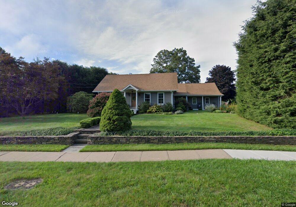
451 N Brooksvale Rd Cheshire, CT 06410
Estimated Value: $464,723 - $512,000
2
Beds
1
Bath
1,840
Sq Ft
$265/Sq Ft
Est. Value
About This Home
This home is located at 451 N Brooksvale Rd, Cheshire, CT 06410 and is currently estimated at $486,931, approximately $264 per square foot. 451 N Brooksvale Rd is a home located in New Haven County with nearby schools including Darcey School, Norton School, and Dodd Middle School.
Ownership History
Date
Name
Owned For
Owner Type
Purchase Details
Closed on
Jul 18, 2017
Sold by
Fielden David
Bought by
Bianchini Debra
Current Estimated Value
Purchase Details
Closed on
Feb 19, 1993
Sold by
Whitehead Gerry W
Bought by
Fielden David S and Bianchini Debra R
Create a Home Valuation Report for This Property
The Home Valuation Report is an in-depth analysis detailing your home's value as well as a comparison with similar homes in the area
Home Values in the Area
Average Home Value in this Area
Purchase History
| Date | Buyer | Sale Price | Title Company |
|---|---|---|---|
| Bianchini Debra | -- | -- | |
| Bianchini Debra | -- | -- | |
| Fielden David S | $147,000 | -- | |
| Fielden David S | $147,000 | -- |
Source: Public Records
Mortgage History
| Date | Status | Borrower | Loan Amount |
|---|---|---|---|
| Previous Owner | Fielden David S | $16,000 | |
| Previous Owner | Fielden David S | $15,000 |
Source: Public Records
Tax History Compared to Growth
Tax History
| Year | Tax Paid | Tax Assessment Tax Assessment Total Assessment is a certain percentage of the fair market value that is determined by local assessors to be the total taxable value of land and additions on the property. | Land | Improvement |
|---|---|---|---|---|
| 2025 | $7,295 | $245,280 | $68,180 | $177,100 |
| 2024 | $6,735 | $245,280 | $68,180 | $177,100 |
| 2023 | $6,345 | $180,810 | $68,170 | $112,640 |
| 2022 | $6,205 | $180,810 | $68,170 | $112,640 |
| 2021 | $6,097 | $180,810 | $68,170 | $112,640 |
| 2020 | $6,007 | $180,810 | $68,170 | $112,640 |
| 2019 | $5,902 | $177,650 | $68,160 | $109,490 |
| 2018 | $5,751 | $176,310 | $68,500 | $107,810 |
| 2017 | $5,631 | $176,310 | $68,500 | $107,810 |
| 2016 | $5,411 | $176,310 | $68,500 | $107,810 |
| 2015 | $5,411 | $176,310 | $68,500 | $107,810 |
| 2014 | $5,333 | $176,310 | $68,500 | $107,810 |
Source: Public Records
Map
Nearby Homes
- 31 Iris Ct
- 21 Hawthorne Dr
- 50 Heritage Dr
- 1325 Avon Blvd
- 40 Whispering Hollow Ct
- 1364 Avon Blvd
- 764 Bethany Mountain Rd
- 164 S Brooksvale Rd
- 50 Wintergreen Ln
- 115 S Brooksvale Rd
- 40 Southwick Ct Unit 106
- 1 Mountaincrest Dr
- 30 Elmwood Dr
- 50 Abrams Rd
- 25 Mountain Brook Dr
- 118 Harrison Rd
- 85 Inverness Ct
- 353 Mount Sanford Rd
- 295 Hotchkiss Ridge
- Lot 3 Mount Sanford Rd
- 445 N Brooksvale Rd
- 1020 Danard Place
- 1011 Danard Place
- 462 N Brooksvale Rd
- 992 Farmington Dr
- 1036 Danard Place
- 1025 Danard Place
- 989 Farmington Dr
- 422 N Brooksvale Rd
- 979 Farmington Dr
- 978 Farmington Dr
- 1048 Danard Place
- 1041 Danard Place
- 91 Crescent Cir
- 969 Farmington Dr
- 480 N Brooksvale Rd
- 77 Crescent Cir
- 968 Farmington Dr
- 103 Crescent Cir
- 65 Crescent Cir